2024
Type of resources
Available actions
Topics
Keywords
Contact for the resource
Provided by
Groups
Years
Representation types
Update frequencies
status
Scale
-

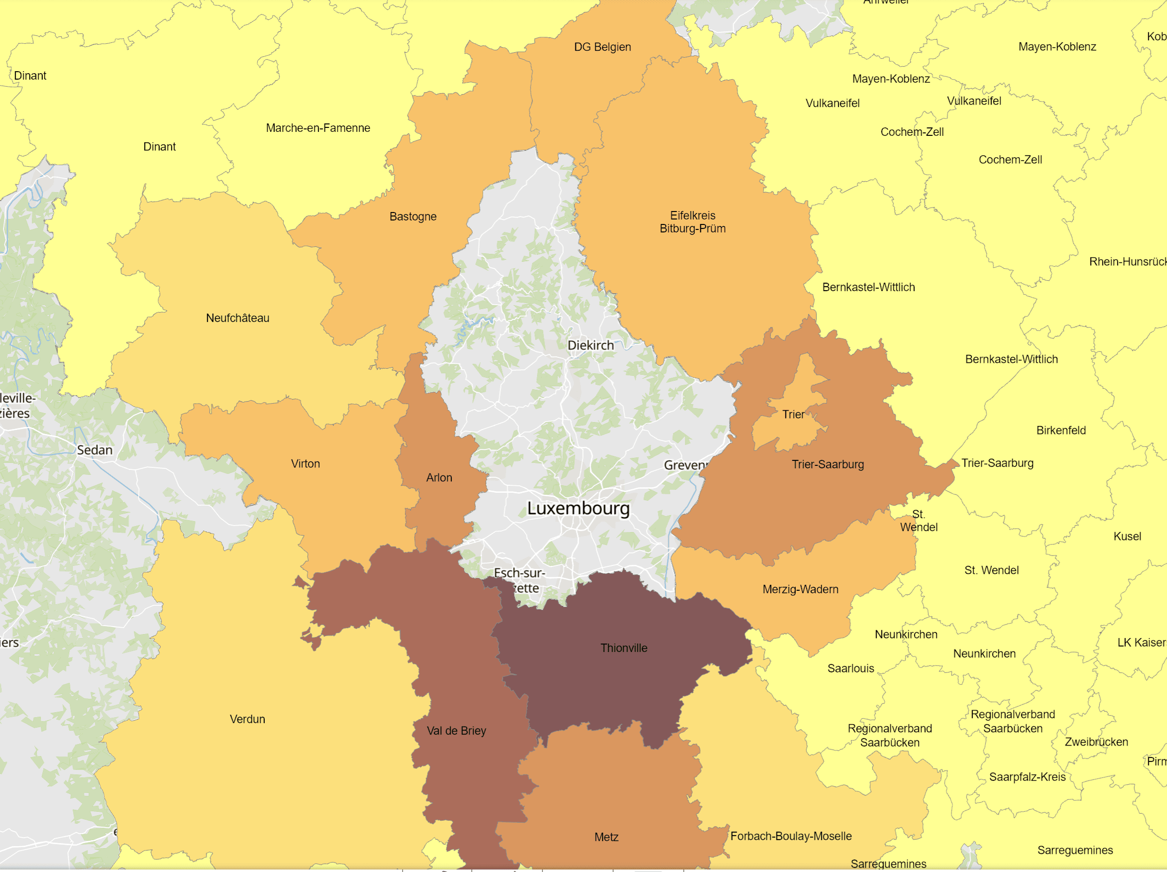
- Cross-border commuters to Luxembourg at place of residence in 2023 - Territorial entities: Kreise, arrondissements - Commuting data sources: IGSS. Calculations: OIE/IBA 2024 - Geodata sources: GeoBasis-DE / BKG, IGN France, NGI-Belgium. Harmonization: SIG-GR / GIS-GR 2024
-
- Cross-border commuters from France to Rhineland-Palatinate at place of work (Kreise): 2013-2023 - Territorial entities: Kreise - Commuting data sources: Bundesagentur für Arbeit. Calculations: OIE/IBA 2024 - Geodata sources: GeoBasis-DE / BKG. Harmonization: SIG-GR / GIS-GR 2024
-
- Cross-border commuters from Rhineland-Palatinate to Luxembourg at place of residence (Kreise): 2013-2023 - Territorial entities: Kreise - Commuting data sources: IGSS 2024. Calculations: OIE/IBA 2024 - Geodata sources: GeoBasis-DE / BKG. Harmonization: SIG-GR / GIS-GR 2024
-
- Cross-border commuters from Wallonia to Luxembourg at place of residence (Arrondissements): 2013-2023 - Territorial entities: Arrondissements - Commuting data sources: INAMI. Calculations: OIE/IBA 2024 - Geodata sources: NGI-Belgium. Harmonization: SIG-GR / GIS-GR 2024
-
Starred restaurants of the Guide Michelin 2024 - Source: Guide Michelin 2024
-
Zones AGE national warning system LU-Alert
-
- Cross-border commuters from France to Saarland at place of work (Kreise): 2013-2023 - Territorial entities: Landkreise - Commuting data sources: Bundesagentur für Arbeit. Calculations: OIE/IBA 2024 - Geodata sources: GeoBasis-DE / BKG. Harmonization: SIG-GR / GIS-GR 2024
-
- Cross-border commuters from the German-speaking community of Belgium to Luxembourg at place of residence (municipalities): 2013-2023 - Territorial entities: municipalities - Commuting data sources: IGSS. Calculations: OIE/IBA 2024 - Geodata sources: NGI-Belgium. Harmonization: SIG-GR / GIS-GR 2024
-
This layer shows the NDVI calculated using the spectral information from a hyperspectral camera (Headwall – Nano) recorded with a drone over the vineyard on September 8, 2020. NDVI (= Normalized Difference Vegetation Index) belongs to the vegetation indices, which can map the vitality of plants by using spectral information in the red and near-infrared. It has a defined value range and can be easily interpreted as healthy vegetation has values from 0.6 to 1 maximum.
-
Field assessment / rating of the vines at the IVV 2023, classes 0 = healthy, 1 = apoplexy, 2A = mild ESCA symptoms, 2B = moderate ESCA symptoms, 2C = severe ESCA symptoms, X = missing vine
 geocatalogue.geoportail.lu