 geocatalogue.geoportail.lu
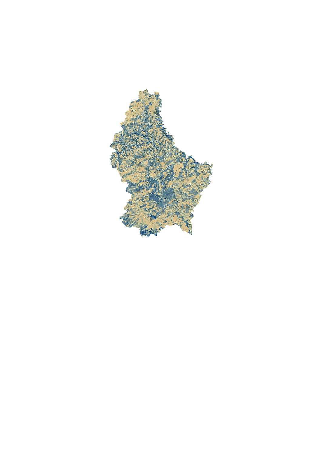
Solar radiation map on 15.05
<p>The solar radiation layers are simulations of solar radiation based on the Digital Surface Model. The simulation considers the topographic situation (surrounding, slope, exposition) as well as time-based variation of the sun radiation for a specific geographic location. The result is a raster visualization of the sun duration per pixel (with 1 m ground resolution). The simulation is configured to return the sun hours per pixel for a given day. Currently 3 days were calculated: 15/02 (winter), 15/05 (spring) and 15/08 (summer).</p> <p>The solar radiation analysis is based on the solar radiation toolset of the ESRI ArcMap toolbox. A detailed documentation can be found in the corresponding documentation by ESRI:
http://desktop.arcgis.com/en/arcmap/10.6/tools/spatial-analyst-toolbox/area-solar-radiation.htm
</p> <a href="http://desktop.arcgis.com/en/arcmap/10.6/tools/spatial-analyst-toolbox/area-solar-radiation.htm">ESRI Documentation</a> <p>The analysis used the following parameters: </p> <p> - Input raster: Digital Surface model provided by the Administration de la navigation aérienne (ANA) based on a LiDAR flight from 2017. (DSM available here :
https://data.public.lu/fr/datasets/digital-surface-model-high-dem-resolution/
)</p> <p> - Latitude : 49.46 °</p> <p> - Time configuration : Time Within a day (for 3 dates: 15/02 winter, 15/05 spring and 15/08 summer)</p> <p> - Hour interval: 0.5 The solar radiation was calculated in 30 min. intervals and summed up per day.</p> <p> - Slope and aspect input : The slope and aspect rasters are calculated from the input digital surface model</p> <p> - Calculation directions: 32, which is adequate for a complex topography.</p> <p> - Diffuse proportion : 0.3 for a generally clear sky conditions. </p> <p> - Transmittitivity : 0.5 for a generally clear sky.</p> <p> - Output raster: The result is an output raster representing the duration of direct incoming solar radiation.</p>
Simple
- Identifier
- / ece9ef19-b1ff-4acc-9d19-c00f7233d648
- Presentation form
- Digital map
- Status
- On going
- Maintenance and update frequency
- As needed
- Entités au Grand-Duché de Luxembourg
-
- Grand-Duché du Luxembourg
- Keywords
-
- solar radiation, urban farming
- Keywords
-
- geoportail.lu
- geoportail.lu themes
-
- Urban Farming
- Energy
- geoportail.lu structure
-
- Urban Farming>Solar radiation analysis
- Energy>Solar power>Solar radiation analysis
- Access constraints
- Other restrictions
- Spatial representation type
- Vector
- Denominator
- 0
- Character set
- UTF8
N
S
E
W
))
- Reference system identifier
- EPSG / http://www.opengis.net/def/crs/EPSG/0/2169
- OnLine resource
-
1806
(
OGC:WMS-1.3.0-http-get-map
)
Ensoleillement au 15.02
- OnLine resource
-
Solar radiation 15.05
Ensoleillement au 15.05
- OnLine resource
-
Solar radiation 15.02
Ensoleillement au 15.02
- File identifier
- ece9ef19-b1ff-4acc-9d19-c00f7233d648 XML
- Metadata language
- Français
- Character set
- UTF8
- Hierarchy level
- Dataset
- Hierarchy level name
- dataset
- Date stamp
- 2021-02-04T22:51:24
- Metadata standard name
- ISO 19115:2003/19139
- Metadata standard version
- 1.0
Overviews
Spatial extent
N
S
E
W
Provided by

Associated resources
Not available