 geocatalogue.geoportail.lu
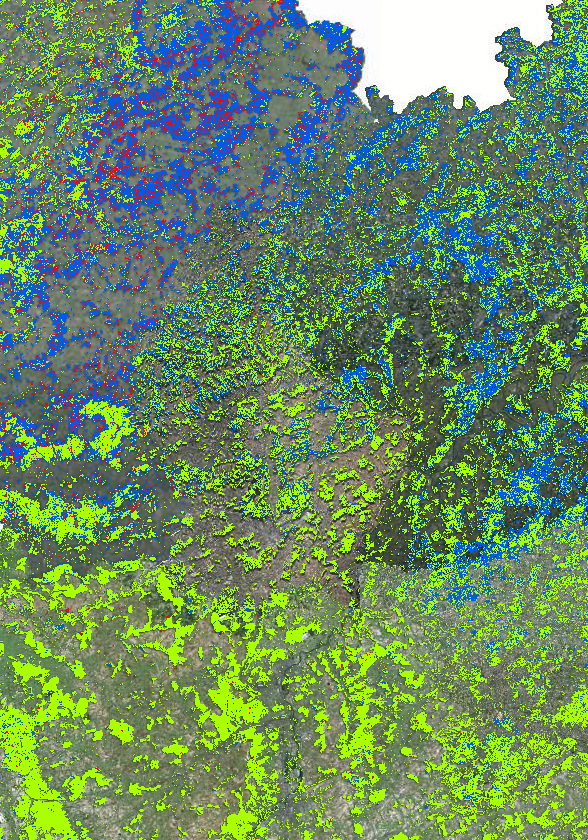
Regiowood: Types de forêts 2019
Regiowood: Forest types 2019
Regiowood: Waldtypenkarte 2019
Cartes des types de forêts en Grande Région 2019
- Source: Projet INTERREG VA Regiowood II ( https://www.regiowood2.info/)
- Sources de données et traitement:
- France/Lorraine : images SPOT4-5 acquises en 2005, images RapidEye acquises en 2010 et 2011. Traîtement: ICube-SERTIT Université de Strasbourg ( https://sertit.unistra.fr)
- Belgique : couverture d’images aériennes de 2009, 2012 et 2016, Couverture LiDAR 2014. Traîtement: Gembloux Agro-Bio Tech Université de Liège ( https://www.gembloux.ulg.ac.be/gestion-des-ressources-forestieres)
- Allemagne et Luxembourg : données cadastrales, Landsat 8 de 2014. . Traîtement: Umweltfernerkundung & Geoinformatik Université de Trèves ( https://www.fernerkundung.uni-trier.de/)
- Données à l'échelle de l'ensemble de la Grande Région à partir de 2016: Sentinel-2 A/B.
Bien que la classification repose sur des méthodologicques différentes selon les regions, le résultat final est une carte transfrontalière cohérente. La precision de la classification est 88%.
Veuillez noter que date des données de la carte de fond "Images aériennes" peut être différente des données Regiowood selon la sous-entité de la Grande Région.
Forest types in the Greater Region 2019
- Source: INTERREG VA project Regiowood II ( https://www.regiowood2.info/en)
- Data sources and processing:
- France/Lorraine: SPOT4-5 images acquired in 2005, RapidEye images acquired in 2010 and 2011. Data processing: ICube-SERTIT University of Strasbourg ( https://sertit.unistra.fr)
- Belgium: aerial image coverage from 2009, 2012 and 2016, LiDAR coverage 2014. Data processing: Gembloux Agro-Bio Tech University of Liège ( https://www.gembloux.ulg.ac.be/gestion-des-ressources-forestieres)
- Germany and Luxembourg: cadastral data, Landsat 8 from 2014. Data processing: Umweltfernerkundung & Geoinformatik University of Trier ( https://www.fernerkundung.uni-trier.de/)
- Data for the entire Greater Region from 2016: Sentinel-2 A/B.
Although the classification is based on different methodologies in different regions, the final result is a consistent cross-border map. The accuracy of the classification is 88%.
Please note that the date of the "Aerial Imagery" background map data may differ from the Regiowood data depending on the sub-entity of the Greater Region.
Waldtypenkarte der Grossregion 2019
- Quelle: INTERREG VA Projekt Regiowood II ( https://www.regiowood2.info/de)
- Verwendete Daten und Bearbeitung:
- Frankreich/Lothringen: SPOT4-5 von 2005, RapidEye von 2010/2011, Bearbeitung: ICube-SERTIT Universität Strasbourg ( https://sertit.unistra.fr).
- Belgien: Luftbilder von 2009, 2012 und 2016, LiDAR Daten von 2014, Bearbeitung: Gembloux Agro-Bio Tech Universität Liège ( https://www.gembloux.ulg.ac.be/gestion-des-ressources-forestieres/).
- Deutschland und Luxembourg: Landesvermessungsdaten (ATKIS, Forsteinrichtung Luxembourg) Landsat 8 von 2014, Bearbeitung: Umweltfernerkundung & Geoinformatik Universität Trier ( https://www.fernerkundung.uni-trier.de/).
- Satellitenbilddaten ab 2016 (gesamte Großregion): Sentinel-2 A/B.
Obgleich der Klassifikation je nach Region eine unterschiedliche Methodik zugrunde liegt, ist das Endergebnis dennoch eine konsistente grenzüberschreitende Karte. Die Klassifikationsgenauigkeit liegt insgesamt bei 88%.
Bitte beachten Sie, dass das Datum der Daten aus der Hintergrundkarte "Luftbild" je nach Teileinheit der Großregion von den Regiowood-Daten abweichen kann.
Simple
-
Date (Creation)Datumsangaben (Erstellung)Date (Création)
- 2021-05-05T00:00:00
-
Citation identifierIdentifikatorIdentificateur
- / 756d6e00-0ec6-47a1-ab15-78b62e3069aa
-
Presentation formPräsentationsformForme de la présentation
-
Digital mapDigitale KarteCarte numérique
-
StatusBearbeitungsstatusEtat
-
CompletedAbgeschlossenFinalisé
- Point of contact
-
Organisation name Individual name Electronic mail address Role SIG-GR - Ministère de l'Energie et de l'Aménagement du territoire - Département de l'aménagement du territoire
Thierry Hengen
AuthorAutorAuteur
-
Maintenance and update frequencyÜberarbeitungsintervallFréquence de mise à jour
-
As neededBei BedarfLorsque nécessaire
- Keywords
-
-
Occupation des sols, forêts, feuillus, résineux, coupe
Land cover, forest, hardwood, softwood, clear cutting
Landnutzung, Wald, Laubwald, Nadelwald, Kahlschlag
-
-
Entités dans la Grande Région
-
-
Grande Région
Greater Region
Großregion
-
-
gis-gr.eu themes
-
-
Occupation des sols
Land cover
Landnutzung
-
-
gis-gr.eu structure
-
-
Occupation des sols>Forêt
Land cover>forest
Landnutzung>Wald
-
- Keywords
-
-
gis-gr.eu
gis-gr.eu
gis-gr.eu
-
-
Access constraintsZugriffseinschränkungenContraintes d'accès
-
Other restrictionsBenutzerdefinierte EinschränkungenAutres restrictions
-
Spatial representation typeRäumliche DarstellungsartType de représentation spatiale
-
VectorVektorVecteur
-
DenominatorMaßstabszahlDénominateur de l'échelle
- 10
-
LanguageSpracheLangue de la ressource
- Deutsch
-
LanguageSpracheLangue de la ressource
- Français
-
LanguageSpracheLangue de la ressource
- English
-
Character setZeichensatzEncodage des caractères
-
UTF8Utf8Utf8
-
Topic categoryISO-ThematikCatégorie ISO
-
-
Imagery base maps earth coverOberflächenbeschreibungCarte de référence de la couverture terrestre
-
))
-
Reference system identifierIdentifikator des ReferenzsystemsNom du système de référence
- EPSG / http://www.opengis.net/def/crs/EPSG/0/3857
- Distribution format
-
Name Version PDF
JPEG
SHAPE
- OnLine resource
-
Protocol Linkage Name OGC:WMS-1.3.0-http-get-map
https://ws.geoportail.lu/wss/service/GR_land_cover_WMS/guest Forest_types_Regiowood_2019
WWW:LINK-1.0-http--related
https://www.regiowood2.info/en WWW:LINK-1.0-http--samples
https://map.sig-gr.eu/theme/occupation_des_sols?version=3&zoom=8&X=777820&Y=6337110&lang=fr&layers=2049&opacities=1&bgLayer=basemap_2015_global Carte interactive
Interactive map
Interaktive Karte
WWW:LINK-1.0-http--link
https://data.public.lu/en/datasets/regiowood-forest-types-2019/ Open data
OGC:WFS
https://ws.geoportail.lu/wss/service/GR_land_cover_WFS/guest land_cover:Forest_types_Regiowood_2019
Metadata
-
File identifierMetadatensatzidentifikatorIdentifiant de la fiche
- 66966386-5183-4d5a-86a1-33cbdcaa3eb2 XML
-
Metadata languageSpracheLangue
- Français
-
Character setZeichensatzJeu de caractères
-
UTF8Utf8Utf8
-
Hierarchy levelHierarchieebeneType de ressource
-
DatasetDatenbestandJeu de données
- Hierarchy level name
-
dataset
-
Date stampDatumDate des métadonnées
- 2025-04-04T11:41:36
- Metadata standard name
-
ISO 19115:2003/19139
- Metadata standard version
-
1.0
- Metadata author
-
Organisation name Individual name Electronic mail address Role SIG-GR - Ministère de l'Energie et de l'Aménagement du territoire - Département de l'aménagement du territoire
Thierry Hengen
Point of contactAnsprechpartnerPoint de contact
- Other language
-
Language Character encoding EnglishEnglischAnglaisUTF8Utf8Utf8GermanDeutschAllemandUTF8Utf8Utf8FrenchFranzösischFrançaisUTF8Utf8Utf8
)))