 geocatalogue.geoportail.lu
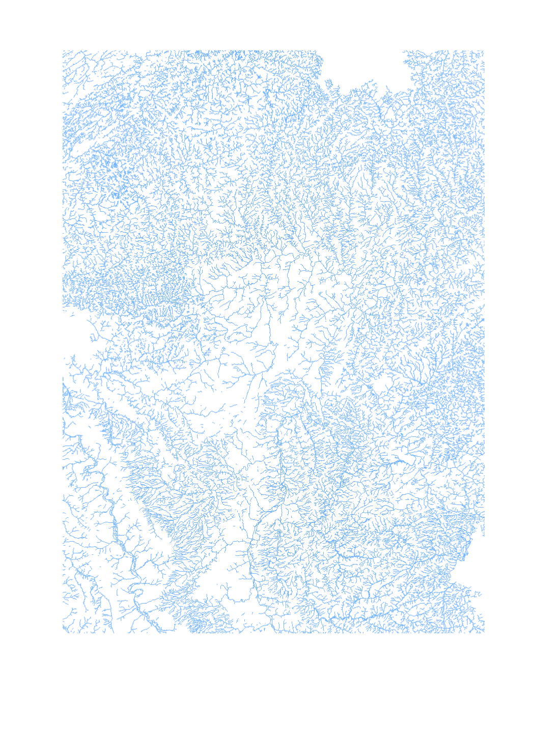
GeoConnectGR: linear watercourses
Final product of the b-solutions project GeoConnectGR: linear watercourses
- Harmonized geodata of the hydrographic network of the Greater Region (scale 1:25.000 - 1:50.000)
- Sources: LVGL Saarland, LVermGeo Rheinland-Pfalz, NGI Belgium, IGN France, ACT Luxembourg
- Harmonization: Federal Agency for Cartography and Geodesy (BKG) based on the data model Core Reference Data (CRD) developed by EuroGeographics
- This data is published for non-commercial uses under the licence CC BY-NC 4.0: https://creativecommons.org/licenses/by-nc/3.0/legalcode
Simple
- Date (Creation)
- 2019-11-05T00:00:00
- Identifier
- / 8042ca91-b205-434c-8f7e-05bc4c21ebaa
- Presentation form
- Digital map
- Status
- Completed
- Maintenance and update frequency
- As needed
- Keywords
-
- hydrographic network, linear
- Entités dans la Grande Région
-
- Greater Region
- gis-gr.eu themes
-
- Environment
- gis-gr.eu structure
-
- Environment>Hydrographic network GeoConnectGR
- Keywords
-
- gis-gr.eu
- Access constraints
- Other restrictions
- Spatial representation type
- Vector
- Denominator
- 50000
- Metadata language
- Deutsch
- Metadata language
- Français
- Metadata language
- English
- Character set
- UTF8
- Topic category
-
- Inland waters
- Environment
))
- Reference system identifier
- EPSG / http://www.opengis.net/def/crs/EPSG/0/3857
- Distribution format
-
-
SHAPE
()
-
SHAPE
()
- OnLine resource
- Interactive map ( WWW:LINK-1.0-http--samples )
- OnLine resource
- Open data ( WWW:LINK-1.0-http--link )
- OnLine resource
- Data licence ( WWW:LINK-1.0-http--related )
- OnLine resource
-
Hydrographic_network_GeoConnectGR:Linear_watercourses_2019
(
OGC:WFS
)
Linear_watercourses_2019
- OnLine resource
-
Linear_watercourses_2019
(
OGC:WMS-1.3.0-http-get-capabilities
)
Linear_watercourses_2019
- File identifier
- 8042ca91-b205-434c-8f7e-05bc4c21ebaa XML
- Metadata language
- Français
- Character set
- UTF8
- Hierarchy level
- Dataset
- Hierarchy level name
- dataset
- Date stamp
- 2025-01-15T13:20:35
- Metadata standard name
- ISO 19115:2003/19139
- Metadata standard version
- 1.0
Overviews
Spatial extent
Provided by
