 geocatalogue.geoportail.lu
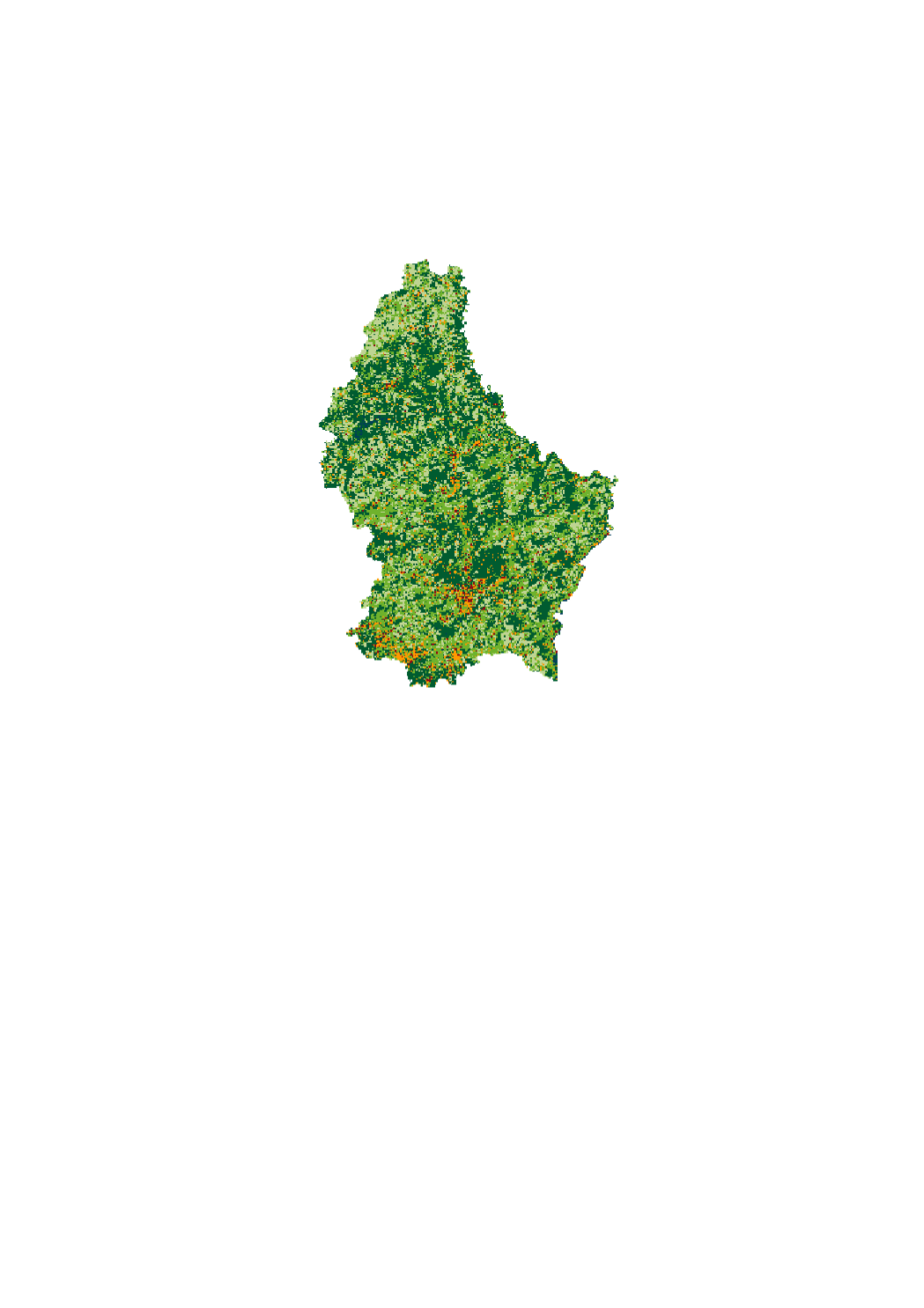
Couverture du sol 2015
Landbedeckung 2015
Landcover 2015
Landbedeckung 2015
La couverture du sol est une description physique de l'espace - l'occupation (bio)physique observée de la surface terrestre, c'est-à-dire ce qui recouvre le sol.
D'Landnotzung entsprécht enger physescher Beschreiwung vum Raum, vun der observéierter (bio-)physescher Bedeckung vun der Äerduewerfläch. Se gëtt un wat op dem Buedem ass a wat en grad bedeckt.
Land cover corresponds to a physical description of space, the observed (bio)physical cover of the earth's surface . It is that which overlays or currently covers the ground.
Die Bodenbedeckung entspricht einer physischen Beschreibung des Raums, der beobachteten (bio-)physischen Bedeckung der Erdoberfläche. Sie gibt an, was über dem Boden liegt oder ihn gerade bedeckt
Simple
-
IdentificateurIdentifierIdentifikatorIdentificateur
- / 7012fa2f-5f37-4aa3-a929-d8c0cdedf408
-
Forme de la présentationPresentation formPräsentationsformForme de la présentation
-
Carte numériqueDigital mapDigitale KarteCarte numérique
-
EtatStatusBearbeitungsstatusEtat
-
Mise à jour continueOn goingKontinuierliche AktualisierungMise à jour continue
Point de contact
Point of contact
Ansprechpartner
Point de contact
Département de l'aménagement du territoire
-
Ministère de l’Environnement, du Climat et du Développement durable & Ministère de l’Énergie et de l’Aménagement du territoire
4, Place de l'Europe
,
Luxembourg
,
L-1499
,
Luxembourg
247 86924
-
Fréquence de mise à jourMaintenance and update frequencyÜberarbeitungsintervallFréquence de mise à jour
-
Lorsque nécessaireAs neededBei BedarfLorsque nécessaire
-
Entités au Grand-Duché de Luxembourg
-
-
Grand-Duché du LuxembourgGrand-Duché du LuxembourgGrand-Duché du LuxembourgGrand-Duché du Luxembourg
-
- Keywords
-
- Keywords
-
-
Couverture du solLandbedeckungLandcoverLandbedeckung
-
OBSOBSOBSOBS
-
geoportail.lugeoportail.lugeoportail.lugeoportail.lu
-
-
geoportail.lu themes
-
-
EnvironnementEmweltEnvironmentUmwelt
-
Grand PublicAllgemengMainAllgemein
-
-
geoportail.lu structure
-
-
Environnement>Occupation du solEnvironnement>Occupation du sol>BuedemnotzungEnvironment>Land useUmwelt>Bodennutzung
-
Grand Public>Couverture du sol>Occupation du solGrand Public>Couverture du sol>Occupation du sol>BuedemnotzungMain>Land surface>Land useAllgemein>Oberflächendarstellung>Bodennutzung
-
-
Contraintes d'utilisationUse constraintsNutzungseinschränkungenContraintes d'utilisation
-
Autres restrictionsOther restrictionsBenutzerdeifinierte EinschränkungenAutres restrictions
- Other constraints
- Creative Commons 1.0 Universal (CC0 1.0) Public Domain Dedication
-
Type de représentation spatialeSpatial representation typeRäumliche DarstellungsartType de représentation spatiale
-
VecteurVectorVektorVecteur
-
Dénominateur de l'échelleDenominatorMassstabszahlDénominateur de l'échelle
- 0
-
Jeu de caractèresCharacter setZeichensatzJeu de caractères
-
Utf8UTF8Utf8Utf8
N
S
E
W
))
-
Nom du système de référenceReference system identifierIdentifikator des ReferenzsystemsNom du système de référence
- EPSG / http://www.opengis.net/def/crs/EPSG/0/2169
-
Ressource en ligneOnLine resourceOnlineRessource en ligne
- https://data.public.lu/fr/datasets/landcover-landuse-2015-1/ ( WWW:LINK-1.0-http--link )
-
Ressource en ligneOnLine resourceOnlineRessource en ligne
-
Couverture du sol 2015 Landbedeckung 2015 Landcover 2015 Landbedeckung 2015
LISL_Landcover_2015
-
Identifiant de la ficheFile identifierMetadatensatzidentifikatorIdentifiant de la fiche
- 7012fa2f-5f37-4aa3-a929-d8c0cdedf408 XML
-
LangueMetadata languageSpracheLangue
- Français
-
Jeu de caractèresCharacter setZeichensatzJeu de caractères
-
Utf8UTF8Utf8Utf8
-
Type de ressourceHierarchy levelHierarchieebeneType de ressource
-
Jeu de donnéesDatasetDatenbestandJeu de données
- Hierarchy level name
- dataset
-
Date des métadonnéesDate stampDatumDate des métadonnées
- 2021-02-15T14:56:24
- Metadata standard name
- ISO 19115:2003/19139
- Metadata standard version
- 1.0
Point de contact
Point of contact
Ansprechpartner
Point de contact
Département de l'aménagement du territoire
-
Ministère de l’Environnement, du Climat et du Développement durable & Ministère de l’Énergie et de l’Aménagement du territoire
4, Place de l'Europe
,
Luxembourg
,
L-1499
,
Luxembourg
247 86924
Overviews
Spatial extent
N
S
E
W
Provided by

Associated resources
Not available