 geocatalogue.geoportail.lu
Interpolation géostatistique O3
Geostatistesch Interpolatioun O3
Geostatistical Interpolation O3
Geostatistische Interpolation O3
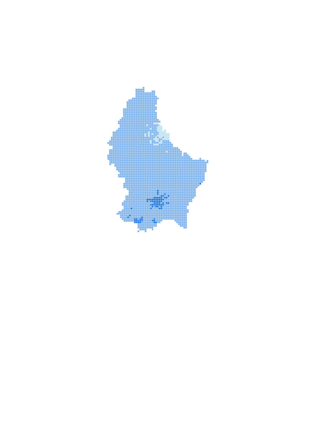
La carte d'interpolation géostatistique montre en temps réel la répartition la plus probable du polluant ozone entre les différents points de mesures fixes qui constituent le réseau télémétrique au Luxembourg, ceci à une résolution spatiale de 1 km2.
D'geostatistesch Interpolatiounskaart weist an Echtzäit déi wahrscheinlechst Ausbreedung vum Loftschadstoff Ozon tëschent den verschiddenen festen Miesspunkten vum telemetreschen Miessnetz vun Lëtzebuerg, dëst matt enger Resolutioun vun 1 km2.
The geostatistical interpolation map shows in real time the most probable distribution of the pollutant ozone between the different fixed measurement points that make up the telemetric network of Luxembourg, this at a resolution of 1km2.
Die geostatistische Interpolationskarte zeigt in Echtzeit die wahrscheinlichste Ausbreitung des Luftschadstoffes Ozon zwischen den verschiedenen festen Messpunkten des telemetrischen Messnetzes in Luxemburg, dies mit einer Auflösung von 1 km2.
Simple
-
IdentificateurCitation identifierIdentifikatorIdentificateur
- / 4ebe5c4d-2318-4caa-bace-3e3784a41509
-
Forme de la présentationPresentation formPräsentationsformForme de la présentation
-
Carte numériqueDigital mapDigitale KarteCarte numérique
-
EtatStatusBearbeitungsstatusEtat
-
Mise à jour continueOn goingKontinuierliche AktualisierungMise à jour continue
-
Fréquence de mise à jourMaintenance and update frequencyÜberarbeitungsintervallFréquence de mise à jour
-
Lorsque nécessaireAs neededBei BedarfLorsque nécessaire
-
Entités au Grand-Duché de Luxembourg
-
-
Grand-Duché du Luxembourg
Grand-Duché du Luxembourg
Grand-Duché du Luxembourg
Grand-Duché du Luxembourg
-
- Keywords
-
-
qualité de l'air, modélisation, interpolation géostatistique, ozone
Loftqualitéit, Modeléierung, geostatistesch Interpolatioun, Ozon
air quality, modelling, geostatistical interpolation, ozone
Luftqualität, Modellierung, geostatistische Interpolation, Ozon
-
- Keywords
-
-
geoportail.lu
geoportail.lu
geoportail.lu
geoportail.lu
-
-
geoportail.lu themes
-
-
Environnement
Emwelt
Environment
Umwelt
-
-
geoportail.lu structure
-
-
Environnement>Qualité de l'air>Modélisation
Environnement>Qualité de l'air>Modélisation>Modeléierung
Environment>Air quality>Modelling
Umwelt>Luftqualität >Modellierung
-
-
Contraintes d'accèsAccess constraintsZugriffseinschränkungenContraintes d'accès
-
Autres restrictionsOther restrictionsBenutzerdefinierte EinschränkungenAutres restrictions
-
Type de représentation spatialeSpatial representation typeRäumliche DarstellungsartType de représentation spatiale
-
VecteurVectorVektorVecteur
-
Dénominateur de l'échelleDenominatorMaßstabszahlDénominateur de l'échelle
- 0
-
Encodage des caractèresCharacter setZeichensatzEncodage des caractères
-
Utf8UTF8Utf8Utf8
))
-
Nom du système de référenceReference system identifierIdentifikator des ReferenzsystemsNom du système de référence
-
EPSG
/
http://www.opengis.net/def/crs/EPSG/0/2169
- OnLine resource
-
Protocol Linkage Name OGC API-Features
https://features.geoportail.lu/collections/1430 OGC API - Features
- OnLine resource
-
Protocol Linkage Name OGC:WMS-1.3.0-http-get-map
https://wms.geoportail.lu/public_map_layers/service 1430
1430
1430
1430
https://map.geoportail.lu/theme/main?version=3&zoom=8&X=667917&Y=6394482&lang=fr&layers=1430&opacities=1 Interpolation géostatistique O3
Geostatistesch Interpolatioun O3
Geostatistical Interpolation O3
Geostatistische Interpolation O3
Metadata
-
Identifiant de la ficheFile identifierMetadatensatzidentifikatorIdentifiant de la fiche
- 4ebe5c4d-2318-4caa-bace-3e3784a41509 XML
-
LangueMetadata languageSpracheLangue
- Français
-
Jeu de caractèresCharacter setZeichensatzJeu de caractères
-
Utf8UTF8Utf8Utf8
-
Type de ressourceHierarchy levelHierarchieebeneType de ressource
-
Jeu de donnéesDatasetDatenbestandJeu de données
- Hierarchy level name
-
dataset
-
Date des métadonnéesDate stampDatumDate des métadonnées
- 2021-07-13T13:37:42Z
- Metadata standard name
-
ISO 19115:2003/19139
- Metadata standard version
-
1.0
- Metadata author
-
Organisation name Individual name Electronic mail address Role Administration de l'Environnement - Unité Surveillance et Évaluation de l'Environnement
Claudine Schiltz
Point de contactPoint of contactAnsprechpartnerPoint de contactAdministration de l'Environnement
- Other language
-
Language Character encoding LëtzebuergeschLuxembourgish; LetzeburgeschLuxemburgischLuxembourgeoisUtf8UTF8Utf8Utf8EngleschEnglishEnglischAnglaisUtf8UTF8Utf8Utf8DäitschGermanDeutschAllemandUtf8UTF8Utf8Utf8FranséischFrenchFranzösischFrançaisUtf8UTF8Utf8Utf8
)))