 geocatalogue.geoportail.lu
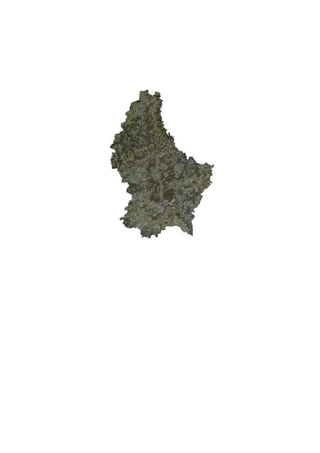
Orthophoto 2007 de l'administration du cadastre et de la topographie
Orthophoto 2007 vun der Kadasterverwaltung
Orthophoto 2007 of the administration du cadastre et de la topographie
Orthophoto 2007 der administration du cadastre et de la topographie
Cette couche contient les orthophotos officielles couvrant le territoire national, et qui ont été faites suivant un survol en automne 2007 sous la responsabilité de l'administration du cadastre et de la topographie.
Dëse Layer enthält déi offiziell Orthophoto vum nationale Gebitt vu Lëtzebuerg, déi opgronn vun enger Iwwerfléiung am Hierscht 2007 am Optrag vun der administration du cadastre et de la topographie gemaach gouf.
This layer contains the official orthophotos covering the national territory of Luxemburg, and that have been produced following a surveying flight in autumn 2007 under the responsibility of the administration du cadastre et de la topographie.
Dieser Layer enthält die amtlichen Orthophotos vom nationalen Gebiet des Großherzogtums Luxemburg, die ausgehend von einer Überfliegung im Herbst 2007 unter der Verantwortung der administration du cadastre et de la topographie erstellt wurden.
Simple
-
Date (Création)Date (Creation)Datumsangaben (Erstellung)Date (Création)
- 2010-06-01T00:00:00
-
Date (Révision)Date (Revision)Datumsangaben (Überarbeitung)Date (Révision)
- 2010-06-01T00:00:00
-
IdentificateurCitation identifierIdentifikatorIdentificateur
- / 3be3d98e-7997-4ff6-8d77-e393a5fc4fdd
-
Forme de la présentationPresentation formPräsentationsformForme de la présentation
-
Carte numériqueDigital mapDigitale KarteCarte numérique
-
EtatStatusBearbeitungsstatusEtat
-
Mise à jour continueOn goingKontinuierliche AktualisierungMise à jour continue
- Point of contact
-
Organisation name Individual name Electronic mail address Role Administration du Cadastre et de la Topographie
Service du géoportail et de l'ILDG (ACT)
Point de contactPoint of contactAnsprechpartnerPoint de contact
-
Fréquence de mise à jourMaintenance and update frequencyÜberarbeitungsintervallFréquence de mise à jour
-
Lorsque nécessaireAs neededBei BedarfLorsque nécessaire
-
Entités au Grand-Duché de Luxembourg
-
-
Grand-Duché du Luxembourg
Grand-Duché du Luxembourg
Grand-Duché du Luxembourg
Grand-Duché du Luxembourg
-
- Keywords
-
- Keywords
-
-
orthophotos
Orthophoto
Orthophoto
Orthophoto
-
image
Loftbild
Image
Bild
-
aérienne
Geodaten
aerial
Luftbild
-
géodonnée
Orthofoto
geodata
Geodaten
-
geoportail.lu
geoportail.lu
geoportail.lu
geoportail.lu
-
-
geoportail.lu themes
-
-
Grand Public
Allgemeng
Main
Allgemein
-
-
geoportail.lu structure
-
-
Grand Public>Couverture du sol>Images aériennes et satellites
Grand Public>Couverture du sol>Images aériennes et satellites>Loft- a Satellitebiller
Main>Land surface>Orthophoto-images
Allgemein>Oberflächendarstellung>Luft und Satellitenbilder
-
-
Contraintes d'utilisationUse constraintsNutzungseinschränkungenContraintes d'utilisation
-
Autres restrictionsOther restrictionsBenutzerdefinierte EinschränkungenAutres restrictions
- Other constraints
-
Creative Commons 1.0 Universal (CC0 1.0) Public Domain Dedication
-
Type de représentation spatialeSpatial representation typeRäumliche DarstellungsartType de représentation spatiale
-
VecteurVectorVektorVecteur
-
Dénominateur de l'échelleDenominatorMaßstabszahlDénominateur de l'échelle
- 5000
-
Encodage des caractèresCharacter setZeichensatzEncodage des caractères
-
Utf8UTF8Utf8Utf8
-
Catégorie ISOTopic categoryISO-ThematikCatégorie ISO
-
-
Sciences de la terre, géosciencesGeoscientific informationGeowissenschaftenSciences de la terre, géosciences
-
Carte de référence de la couverture terrestreImagery base maps earth coverOberflächenbeschreibungCarte de référence de la couverture terrestre
-
))
-
Nom du système de référenceReference system identifierIdentifikator des ReferenzsystemsNom du système de référence
- EPSG / http://www.opengis.net/def/crs/EPSG/0/2169
- OnLine resource
-
Protocol Linkage Name OGC:WMS-1.3.0-http-get-map
https://wms.geoportail.lu/public_map_layers/service 231
231
231
231
OGC:WMS-1.3.0-http-get-map
http://wmts1.geoportail.lu/opendata/service?request=getCapabilities&service=WMS&version=1.3.0 ortho_2007
WWW:LINK-1.0-http--link
https://data.public.lu/fr/datasets/orthophoto-officelle-du-grand-duche-de-luxembourg-edition-2017/
- OnLine resource
-
Protocol Linkage Name https://map.geoportail.lu/theme/main?version=3&zoom=8&X=667917&Y=6394482&lang=fr&layers=231&opacities=1 Orthophoto 2007
Orthophoto 2007
Orthophoto 2007
Orthophoto 2007
Metadata
-
Identifiant de la ficheFile identifierMetadatensatzidentifikatorIdentifiant de la fiche
- 3be3d98e-7997-4ff6-8d77-e393a5fc4fdd XML
-
LangueMetadata languageSpracheLangue
- Français
-
Jeu de caractèresCharacter setZeichensatzJeu de caractères
-
Utf8UTF8Utf8Utf8
-
Type de ressourceHierarchy levelHierarchieebeneType de ressource
-
Jeu de donnéesDatasetDatenbestandJeu de données
- Hierarchy level name
-
dataset
-
Date des métadonnéesDate stampDatumDate des métadonnées
- 2021-02-04T23:34:16
- Metadata standard name
-
ISO 19115:2003/19139
- Metadata standard version
-
1.0
- Metadata author
-
Organisation name Individual name Electronic mail address Role Administration du Cadastre et de la Topographie
Service du géoportail et de l'ILDG (ACT)
Point de contactPoint of contactAnsprechpartnerPoint de contact
- Other language
-
Language Character encoding LëtzebuergeschLuxembourgish; LetzeburgeschLuxemburgischLuxembourgeoisUtf8UTF8Utf8Utf8EngleschEnglishEnglischAnglaisUtf8UTF8Utf8Utf8DäitschGermanDeutschAllemandUtf8UTF8Utf8Utf8FranséischFrenchFranzösischFrançaisUtf8UTF8Utf8Utf8
)))