 geocatalogue.geoportail.lu
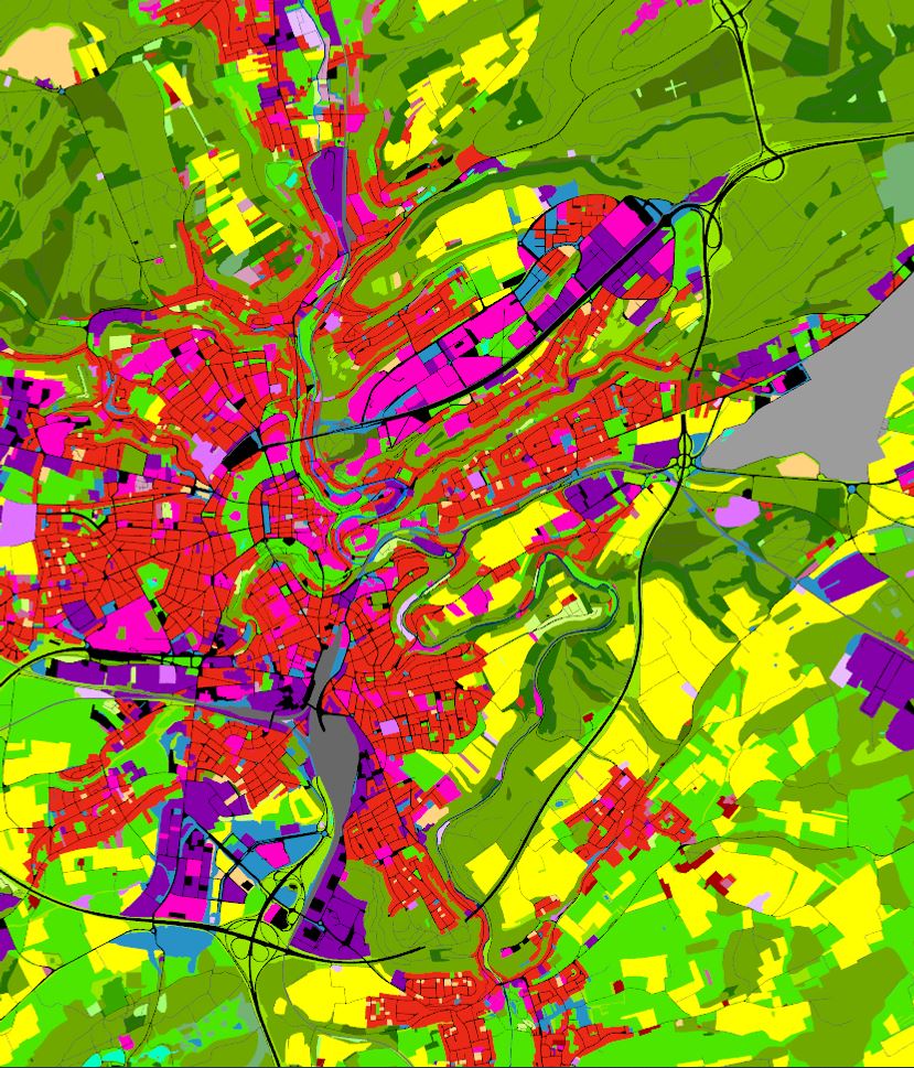
Utilisation du sol 2018
Landnotzung 2018
Land Use 2018
Landnutzung 2018
L’utilisation du sol selon la dimension fonctionnelle renvoie à la description des zones selon leur finalité socio-économique
D'Buedemnotzung no senger funktioneller Dimensioun entsprécht enger Beschreiwung vu Flächen opgrond hirem sozioekonomeschen Zweck
Land Use in terms of functional dimension corresponds to the description of areas in terms of their socio-economic purpose
Die Bodennutzung in Hinblick auf die funktionale Dimension entspricht der Beschreibung von Gebieten bezüglich ihres sozioökonomischen Zwecks
Simple
-
IdentificateurIdentifierIdentifikatorIdentificateur
- / e4572e0b-1b40-4834-b6c3-ccab83f75f57
-
Forme de la présentationPresentation formPräsentationsformForme de la présentation
-
Carte numériqueDigital mapDigitale KarteCarte numérique
-
EtatStatusBearbeitungsstatusEtat
-
Mise à jour continueOn goingKontinuierliche AktualisierungMise à jour continue
-
Fréquence de mise à jourMaintenance and update frequencyÜberarbeitungsintervallFréquence de mise à jour
-
Lorsque nécessaireAs neededBei BedarfLorsque nécessaire
-
Entités au Grand-Duché de Luxembourg
-
-
Grand-Duché du LuxembourgGrand-Duché du LuxembourgGrand-Duché du LuxembourgGrand-Duché du Luxembourg
-
- Keywords
-
- Keywords
-
-
geoportail.lugeoportail.lugeoportail.lugeoportail.lu
-
Utilisation du solLandnotzungLand UseLandnutzung
-
-
geoportail.lu themes
-
-
EnvironnementEmweltEnvironmentUmwelt
-
Grand PublicAllgemengMainAllgemein
-
-
geoportail.lu structure
-
-
Environnement>Utilisation et couverture du sol>LIS-L Utilisation du solEnvironnement>Landnotzung a Landbedeckungl>LIS-L LandnotzungEnvironment>Land Use and Land Cover>LIS-L Land UseUmwelt>Landnutzung und Landbedeckung>LIS-L Landnutzung
-
Grand Public>Couverture du sol>Utilisation et couverture du sol>LIS-L Utilisation du solGrand Public>Couverture du sol>Landnotzung a Landbedeckungl>LIS-L LandnotzungMain>Land surface>Land Use and Land Cover>LIS-L Land UseAllgemein>Oberflächendarstellung>Landnutzung und Landbedeckung>LIS-L Landnutzung
-
-
Contraintes d'accèsAccess constraintsZugriffseinschränkungenContraintes d'accès
-
Autres restrictionsOther restrictionsBenutzerdeifinierte EinschränkungenAutres restrictions
-
Type de représentation spatialeSpatial representation typeRäumliche DarstellungsartType de représentation spatiale
-
VecteurVectorVektorVecteur
-
Dénominateur de l'échelleDenominatorMassstabszahlDénominateur de l'échelle
- 0
-
Jeu de caractèresCharacter setZeichensatzJeu de caractères
-
Utf8UTF8Utf8Utf8
N
S
E
W
))
-
Nom du système de référenceReference system identifierIdentifikator des ReferenzsystemsNom du système de référence
- EPSG / http://www.opengis.net/def/crs/EPSG/0/2169
-
Ressource en ligneOnLine resourceOnlineRessource en ligne
-
1970 1970 1970 1970
(
OGC:WMS-1.3.0-http-get-map
)
Utilisation du sol 2018Utilisation du sol 2018Utilisation du sol 2018Utilisation du sol 2018
-
Ressource en ligneOnLine resourceOnlineRessource en ligne
- Utilisation du sol 2018 Landnotzung 2018 Land Use 2018 Landnutzung 2018 ( UKST )
-
Ressource en ligneOnLine resourceOnlineRessource en ligne
- https://data.public.lu/fr/datasets/lis-l-land-use-2007-2015-2018/ ( WWW:LINK-1.0-http--link )
-
Identifiant de la ficheFile identifierMetadatensatzidentifikatorIdentifiant de la fiche
- e4572e0b-1b40-4834-b6c3-ccab83f75f57 XML
-
LangueMetadata languageSpracheLangue
- Français
-
Jeu de caractèresCharacter setZeichensatzJeu de caractères
-
Utf8UTF8Utf8Utf8
-
Type de ressourceHierarchy levelHierarchieebeneType de ressource
-
Jeu de donnéesDatasetDatenbestandJeu de données
- Hierarchy level name
- dataset
-
Date des métadonnéesDate stampDatumDate des métadonnées
- 2021-11-05T12:06:12
- Metadata standard name
- ISO 19115:2003/19139
- Metadata standard version
- 1.0
Point de contact
Point of contact
Ansprechpartner
Point de contact
Département de l'aménagement du territoire
-
Ministère de l’Environnement, du Climat et du Développement durable & Ministère de l’Énergie et de l’Aménagement du territoire
(
)
4, Place de l'Europe
,
Luxembourg
,
L-1499
,
Luxembourg
247 86924
Overviews
Spatial extent
N
S
E
W
Provided by

Associated resources
Not available