 geocatalogue.geoportail.lu
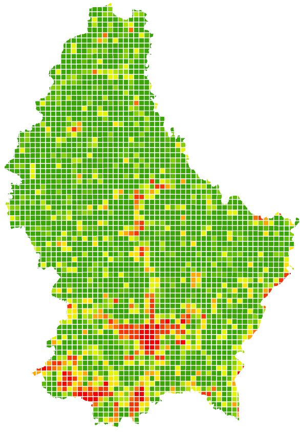
Imperviousness degree (Grid 1km²)
Imperviousness degree (Grid 1 km²) based on LIS-L Land-Cover 2018
Simple
- Identifier
- / 8dc777d0-f910-4c69-a476-85a73dcd8474
- Presentation form
- Digital map
- Status
- On going
- Maintenance and update frequency
- As needed
- Entités au Grand-Duché de Luxembourg
-
- Grand-Duché du Luxembourg
- Keywords
-
- Land Cover
- Keywords
-
- geoportail.lu
- geoportail.lu themes
-
- Urban planning
- Main
- geoportail.lu structure
-
- Urban planning>Territorial analysis>Soil sealing
- Main>Land surface>Land Use and Land Cover>Imperviousness degree
- Access constraints
- Other restrictions
- Spatial representation type
- Vector
- Denominator
- 0
- Character set
- UTF8
N
S
E
W
))
- Reference system identifier
- EPSG / http://www.opengis.net/def/crs/EPSG/0/2169
- OnLine resource
-
2215
(
OGC:WMS-1.3.0-http-get-map
)
Taux d'imperméabilisation du sol (Quadrillage 1km²)
- OnLine resource
- Imperviousness degree (Grid 1km²) ( UKST )
- File identifier
- 8dc777d0-f910-4c69-a476-85a73dcd8474 XML
- Metadata language
- Français
- Character set
- UTF8
- Hierarchy level
- Dataset
- Hierarchy level name
- dataset
- Date stamp
- 2022-01-18T16:37:40
- Metadata standard name
- ISO 19115:2003/19139
- Metadata standard version
- 1.0
Point of contact
Département de l'aménagement du territoire
-
Ministère de l’Environnement, du Climat et du Développement durable & Ministère de l’Énergie et de l’Aménagement du territoire
(
)
4, Place de l'Europe
,
Luxembourg
,
L-1499
,
Luxembourg
247 86924
Overviews
Spatial extent
N
S
E
W
Provided by

Associated resources
Not available