 geocatalogue.geoportail.lu
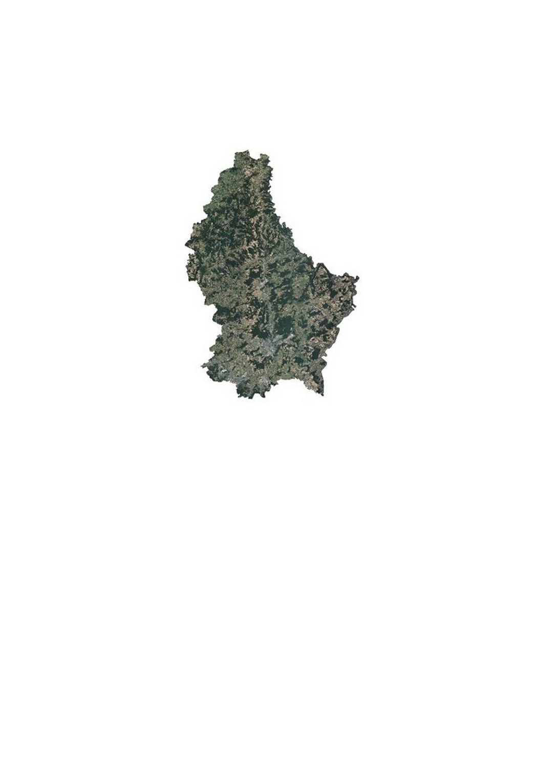
Orthophoto 2018 de l'administration du cadastre et de la topographie
Orthophoto 2018 vun der Kadaster- an Topgraphieverwaltung
Orthophoto 2018 of the land registry and topography administration
Orthophoto 2018 der Kataster- und Topographieverwaltung
Cette couche contient les orthophotos officielles couvrant le territoire national. 4 vols ont été réalisés les 2, 8 et 27 juillet et le 5 août 2018, avec une élévation solaire de > 35°. La résolution au sol native est <0,20m GSD (Ground Sampling Distance). Le déversement sur image, général est inférieur ou égal à 25cm, alors que le déversement sur la Ville de Luxembourg est inférieur ou égal à 15cm, pour une zone de 10x9 km soit 90km2, centrée sur les coordonnées Est 78000 et Nord 74500. La couverture du Grand-Duché du Luxembourg est assurée avec un débord de minimum 50m au-delà de la limite d'Etat.
Dëse Layer enthält déi offiziell Orthophoto vum Territoire vu Lëtzebuerg. 4 Iwwerfléiungen sin den 2., 8. an 27. Juli an 5. August 2018, bei engem Sonnestand vun > 35° duerchgefouert ginn. D'Opléisung vun den Pixelen um Buedem läit bei <0,20m GSD (Ground Sampling Distance). Den Bildsturz läit beim ganzen Land bei <25%, mat Ausnam vun der Stad Lëtzebuerg, wou en op engem Gebitt vun 10x9 km (90km2, zentréiert op den Koordinaten 78000 Ost an 74500 Nord) bei <15% läit. Op den Grenzen gëtt en Gebitt vun 50m iwwert d'Landesgrenzen eraus mat erfaasst.
This layer contains the official orthophotos covering the national territory of Luxembourg. The 4 surveying flights took place on 2, 8 and 27 July and 5 August 2018, with a sun position of > 35°. The ground sampling distance is <0,20m. The perspective displacement is in general <25%, except for Luxembourg-City, where it is <15% for a zone of 10x9km (90km2, centered on the coordinates 78000 east and 74500 north). On the borders, a zone of 50m behind the country border is included.
Dieser Layer enthält die amtlichen Orthophotos vom gesamten Gebiet des Großherzogtums Luxemburg. 4 Überfliegungen wurden am 2., 8.. und 27. Juli und 5. August 2018, bei einem Sonnenstand von > 35° durchgeführt. Die Bodenauflösung liegt bei <0,20m GSD (Ground Sampling Distance). Der Bildsturz liegt für das ganze Land bei <25%, mit Ausnahme von Luxemburg-Stadt, wo er auf einem Gebiet von 10x9 km (90km2, zentriert auf den Koordinaten 78000 Ost und 74500 Nord) bei <15% liegt. An den Grenzen wird ein Gebiet bis 50m über die Landesgrenzen hinaus mit abgedeckt.
Simple
-
IdentificateurIdentificateurIdentifierIdentifikator
- / 6fde72c4-802f-4663-be74-5fa5901cb4f0
-
Forme de la présentationForme de la présentationPresentation formPräsentationsform
-
Carte numériqueCarte numériqueDigital mapDigitale Karte
-
EtatEtatStatusBearbeitungsstatus
-
Mise à jour continueMise à jour continueOn goingKontinuierliche Aktualisierung
Point de contact
Point de contact
Point of contact
Ansprechpartner
Administration du Cadastre et de la Topographie
-
Administration du Cadastre et de la Topographie
1, Rue Charles Darwin
,
Luxembourg
,
L-1433
,
Luxembourg
247-54400
-
Fréquence de mise à jourFréquence de mise à jourMaintenance and update frequencyÜberarbeitungsintervall
-
Lorsque nécessaireLorsque nécessaireAs neededBei Bedarf
- Entités au Grand-Duché de Luxembourg
-
-
Grand-Duché du LuxembourgGrand-Duché du LuxembourgGrand-Duché du LuxembourgGrand-Duché du Luxembourg
-
- Keywords
-
- Keywords
-
-
orthophotoOrthophotoorthophotoOrthophoto
-
imageLoftbildaerialLuftbild
-
aàrienneLoftopnamphotographLuftaufnahme
-
géodonnéeGeodatengeodataGeodaten
-
2018201820182018
-
geoportail.lugeoportail.lugeoportail.lugeoportail.lu
-
- geoportail.lu themes
-
-
Grand PublicAllgemengMainAllgemein
-
EauWasserWaterWasser
-
- geoportail.lu structure
-
-
Grand Public>Couverture du sol>Images aériennes et satellitesGrand Public>Couverture du sol>Images aériennes et satellites>Loft- a SatellitebillerMain>Land surface>Orthophoto-imagesAllgemein>Oberflächendarstellung>Luft und Satellitenbilder
-
Eau>Données de base>Photographies aériennes et spatialesEau>Données de base>Photographies aériennes et spatiales>Loft- an SatellitebillerWater>Geographical location>Aerial and satellite photographsWasser>Basisdaten>Luft- und Satellitenbilder
-
-
Contraintes d'utilisationContraintes d'utilisationUse constraintsNutzungseinschränkungen
-
Autres restrictionsAutres restrictionsOther restrictionsBenutzerdeifinierte Einschränkungen
- Other constraints
- Creative Commons 1.0 Universal (CC0 1.0) Public Domain Dedication
-
Type de représentation spatialeType de représentation spatialeSpatial representation typeRäumliche Darstellungsart
-
VecteurVecteurVectorVektor
-
Dénominateur de l'échelleDénominateur de l'échelleDenominatorMassstabszahl
- 0
-
Jeu de caractèresJeu de caractèresCharacter setZeichensatz
-
Utf8Utf8UTF8Utf8
N
S
E
W
))
-
Nom du système de référenceNom du système de référenceReference system identifierIdentifikator des Referenzsystems
- EPSG / http://www.opengis.net/def/crs/EPSG/0/2169
-
Ressource en ligneRessource en ligneOnLine resourceOnline
-
1527 1527 1527 1527
(
OGC:WMS-1.3.0-http-get-map
)
Orthophoto 2018Orthophoto 2018Orthophoto 2018Orthophoto 2018
-
Ressource en ligneRessource en ligneOnLine resourceOnline
-
ortho_2018
(
OGC:WMS-1.3.0-http-get-map
)
ortho_2018
-
Ressource en ligneRessource en ligneOnLine resourceOnline
-
Orthophoto 2018 Orthophoto 2018 Orthophoto 2018 Orthophoto 2018
ortho_2018
-
Identifiant de la ficheIdentifiant de la ficheFile identifierMetadatensatzidentifikator
- 6fde72c4-802f-4663-be74-5fa5901cb4f0 XML
-
LangueLangueMetadata languageSprache
- Français
-
Jeu de caractèresJeu de caractèresCharacter setZeichensatz
-
Utf8Utf8UTF8Utf8
-
Type de ressourceType de ressourceHierarchy levelHierarchieebene
-
Jeu de donnéesJeu de donnéesDatasetDatenbestand
- Hierarchy level name
- dataset
-
Date des métadonnéesDate des métadonnéesDate stampDatum
- 2021-02-04T23:00:25
- Metadata standard name
- ISO 19115:2003/19139
- Metadata standard version
- 1.0
Point de contact
Point de contact
Point of contact
Ansprechpartner
Administration du Cadastre et de la Topographie
-
Administration du Cadastre et de la Topographie
1, Rue Charles Darwin
,
Luxembourg
,
L-1433
,
Luxembourg
247-54400
Overviews
Spatial extent
N
S
E
W
Provided by

Associated resources
Not available