 geocatalogue.geoportail.lu
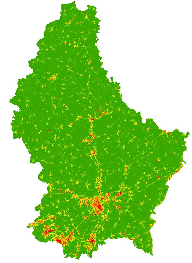
Imperviousness degree (Grid 100m)
Imperviousness degree (Grid 100m) based on LIS-L Land-Cover 2018
Simple
- Citation identifier
- / 210db74a-e33a-401b-9e17-2cd966cdcd1f
- Presentation form
- Digital map
- Status
- On going
- Maintenance and update frequency
- As needed
-
Entités au Grand-Duché de Luxembourg
-
-
Grand-Duché du Luxembourg
-
- Keywords
-
-
Land Cover
-
- Keywords
-
-
geoportail.lu
-
-
geoportail.lu themes
-
-
Urban planning
-
Main
-
-
geoportail.lu structure
-
-
Urban planning>Territorial analysis>Soil sealing
-
Main>Land surface>Land Use and Land Cover>Imperviousness degree
-
- Access constraints
- Other restrictions
- Spatial representation type
- Vector
- Denominator
- 0
- Character set
- UTF8
N
S
E
W
))
- Reference system identifier
- EPSG / http://www.opengis.net/def/crs/EPSG/0/2169
- OnLine resource
-
Protocol Linkage Name OGC:WMS-1.3.0-http-get-map
https://wms.geoportail.lu/public_map_layers/service 2216
UKST
https://map.geoportail.lu/theme/at?version=3&zoom=14&X=682859&Y=6378502&lang=fr&rotation=0&layers=2216&opacities=1&bgLayer=orthogr_2013_global Imperviousness degree (Grid 100m)
WWW:LINK-1.0-http--link
https://data.public.lu/fr/datasets/lis-l-land-cover-2018/#_
Metadata
- File identifier
- 210db74a-e33a-401b-9e17-2cd966cdcd1f XML
- Metadata language
- Français
- Character set
- UTF8
- Hierarchy level
- Dataset
- Hierarchy level name
-
dataset
- Date stamp
- 2022-01-18T17:10:03
- Metadata standard name
-
ISO 19115:2003/19139
- Metadata standard version
-
1.0
- Metadata author
-
Organisation name Individual name Electronic mail address Role Département de l'aménagement du territoire
Ministère de l’Environnement, du Climat et du Développement durable & Ministère de l’Énergie et de l’Aménagement du territoire
Point of contact
- Other language
-
Language Character encoding Luxembourgish; Letzeburgesch UTF8 English UTF8 German UTF8 French UTF8
)))