 geocatalogue.geoportail.lu
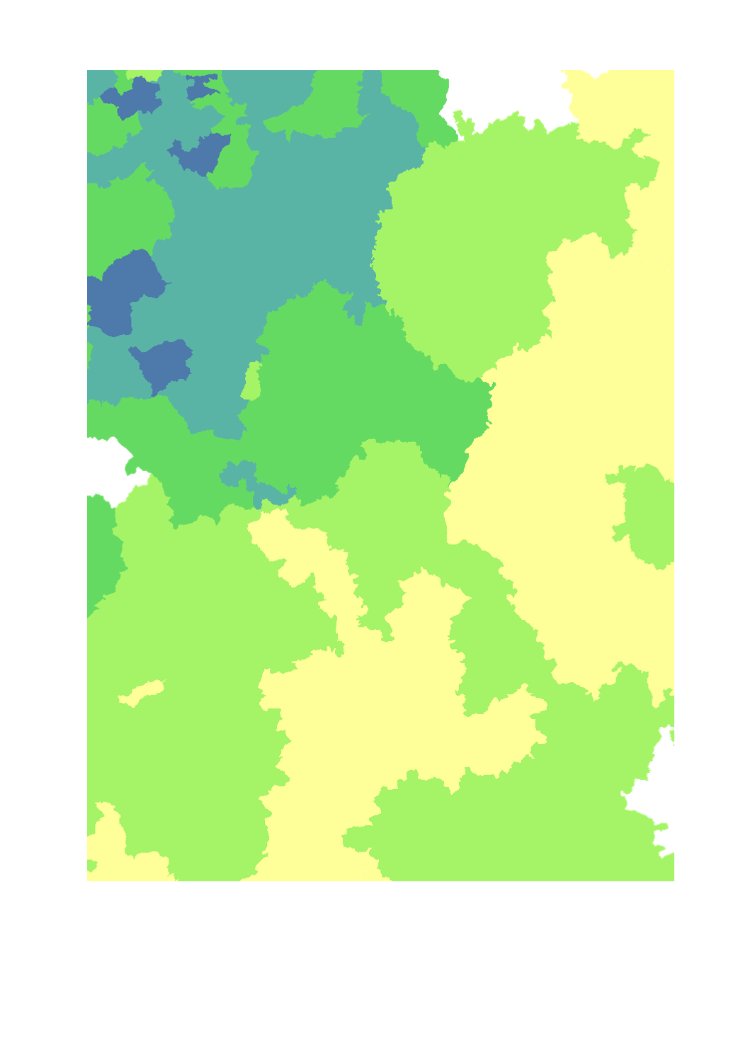
Cattle and pig density per agricultural area
- Livestock units of cattle and pigs per ha of agricultural area
- Territorial entity: Lorraine: canton (2010), Luxembourg: canton (2015), Rhineland-Palatinate: Landkreise and kreisfreie Städte (2010), Saarland: Landkreise (2016), Wallonia: municipality (2015)
- Sources: DRAAF Grand Est 2017; ASTA Luxembourg 2017; Statistisches Landesamt Rheinland-Pfalz 2017; Statistisches Amt Saarland 2017, Direction générale statistique 2017; Groupe de travail "Agriculture et forêt" de la Grande Région. Harmonization: SIG-GR / GIS-GR 2018
Simple
- Date (Creation)
- 2018-11-20T00:00:00
- Citation identifier
- / ebf9ce69-85ba-4b5f-bb93-d1f532a4016f
- Presentation form
- Digital map
- Status
- Completed
- Point of contact
-
Organisation name Individual name Electronic mail address Role SIG-GR - Ministère de l'Energie et de l'Aménagement du territoire - Département de l'aménagement du territoire
Thierry Hengen
Author
- Maintenance and update frequency
- As needed
- Keywords
-
-
Agriculture, cattle, pig, LU
-
-
Entités dans la Grande Région
-
-
Greater Region
-
-
gis-gr.eu themes
-
-
Agriculture
-
-
gis-gr.eu structure
-
-
Agriculture>Cattle and pig density
-
- Keywords
-
-
gis-gr.eu
-
- Access constraints
- Other restrictions
- Spatial representation type
- Vector
- Denominator
- 250000
- Language
- Deutsch
- Language
- Français
- Language
- English
- Character set
- UTF8
- Topic category
-
- Farming
))
- Reference system identifier
- EPSG / http://www.opengis.net/def/crs/EPSG/0/3857
- Distribution format
-
Name Version SHAPE
JPEG
PDF
- OnLine resource
-
Protocol Linkage Name WWW:LINK-1.0-http--samples
https://map.gis-gr.eu/theme/agriculture?version=3&zoom=8&X=667917&Y=6394482&lang=en&layers=1798&opacities=1&bgLayer=basemap_2015_global Interactive map
WWW:LINK-1.0-http--link
https://data.public.lu/en/datasets/cattle-and-pig-density-per-agricultural-area/ Open data
OGC:WMS-1.3.0-http-get-map
https://ws.geoportail.lu/wss/service/GR_Agriculture_WMS/guest cattle_pig_density_per_agricultural_area
OGC:WFS
https://ws.geoportail.lu/wss/service/GR_Agriculture_WFS/guest Agriculture:cattle_pig_density_per_agricultural_area
Metadata
- File identifier
- ebf9ce69-85ba-4b5f-bb93-d1f532a4016f XML
- Metadata language
- Français
- Character set
- UTF8
- Hierarchy level
- Dataset
- Hierarchy level name
-
dataset
- Date stamp
- 2025-01-13T09:52:48
- Metadata standard name
-
ISO 19115:2003/19139
- Metadata standard version
-
1.0
- Metadata author
-
Organisation name Individual name Electronic mail address Role SIG-GR - Ministère de l'Energie et de l'Aménagement du territoire - Département de l'aménagement du territoire
Thierry Hengen
Point of contact
- Other language
-
Language Character encoding English UTF8 German UTF8 French UTF8
)))