 geocatalogue.geoportail.lu
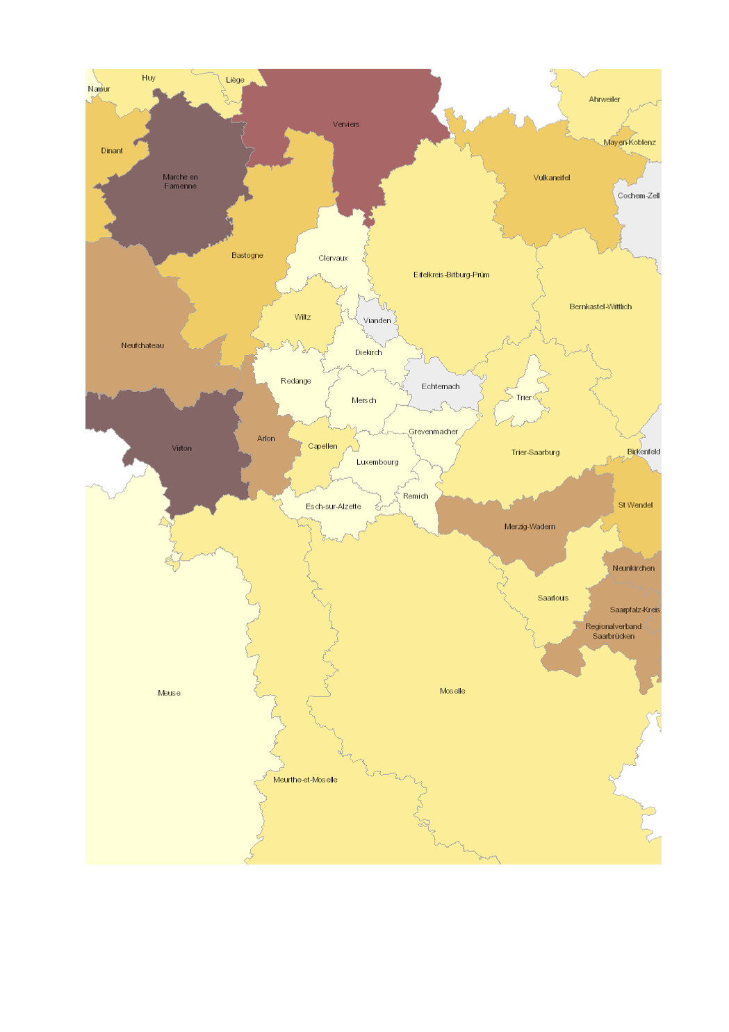
Share of total UAA occupied by organic farming 2016-2017
- Share of total utilised agricultural area (UAA) occupied by organic farming (2016-2017)
- Territorial entities: arrondissements (Wallonie), départements (Lorraine), cantons (Luxembourg), Kreise (Saarland, Rheinland-Pfalz)
- Statistical data sources: Division des Statistiques Agricoles, des Marchés Agricoles et des Relations Extérieures (LUX) 2017; Natagriwal 2017 ; Ministerium für Umwelt und Verbraucherschutz Saarland 2017; ADD Rheinland-Pfalz 2016; Agence BIO / OC Agreste 2016. Harmonization: IGEAT 2018
- Geodata sources: ACT Luxembourg 2017, IGN France 2017, GeoBasis-DE / BKG 2017, NGI-Belgium 2017. Harmonization: SIG-GR / GIS-GR 2018
Simple
- Date (Creation)
- 2019-06-13T00:00:00
- Citation identifier
- / e101577d-6521-4ba3-bd88-ea4881dc242b
- Presentation form
- Digital map
- Status
- Completed
- Point of contact
-
Organisation name Individual name Electronic mail address Role SIG-GR - Ministère de l'Energie et de l'Aménagement du territoire - Département de l'aménagement du territoire
Thierry Hengen
Author
- Maintenance and update frequency
- Continual
- Keywords
-
-
Agriculture, organic
-
-
Entités dans la Grande Région
-
-
Greater Region
-
-
gis-gr.eu themes
-
-
Agriculture
-
-
gis-gr.eu structure
-
-
Agriculture>Organic farming
-
- Keywords
-
-
gis-gr.eu
-
- Access constraints
- Other restrictions
- Spatial representation type
- Vector
- Denominator
- 250000
- Language
- Deutsch
- Language
- Français
- Language
- English
- Character set
- UTF8
- Topic category
-
- Farming
))
- Reference system identifier
- EPSG / http://www.opengis.net/def/crs/EPSG/0/3857
- Distribution format
-
Name Version SHAPE
PDF
JPEG
- OnLine resource
-
Protocol Linkage Name WWW:LINK-1.0-http--samples
https://map.gis-gr.eu/theme/agriculture?version=3&zoom=8&X=667917&Y=6394482&lang=en&layers=1841&opacities=1&bgLayer=basemap_2015_global Interactive map
WWW:LINK-1.0-http--link
https://data.public.lu/en/datasets/share-of-total-uaa-occupied-by-organic-farming-2016-2017 Open data
OGC:WMS-1.3.0-http-get-map
https://ws.geoportail.lu/wss/service/GR_Agriculture_WMS/guest share_organic_farming_2016-2017
OGC:WFS
https://ws.geoportail.lu/wss/service/GR_Agriculture_WFS/guest Agriculture:share_organic_farming_2016-2017
Metadata
- File identifier
- e101577d-6521-4ba3-bd88-ea4881dc242b XML
- Metadata language
- Français
- Character set
- UTF8
- Hierarchy level
- Dataset
- Hierarchy level name
-
dataset
- Date stamp
- 2025-01-10T08:58:41
- Metadata standard name
-
ISO 19115:2003/19139
- Metadata standard version
-
1.0
- Metadata author
-
Organisation name Individual name Electronic mail address Role SIG-GR - Ministère de l'Energie et de l'Aménagement du territoire - Département de l'aménagement du territoire
Thierry Hengen
Point of contact
- Other language
-
Language Character encoding English UTF8 German UTF8 French UTF8
)))