 geocatalogue.geoportail.lu
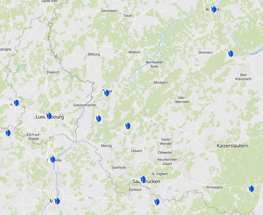
Projet INTER'RED: Intervention en milieu périlleux
INTER'RED project: Special rescue from heights and depths
INTER'ED Projekt: Spezielle Rettung aus Höhen und Tiefen
- Projet INTER'RED: Equipes spécialisées - Intervention en milieu périlleux
- Sources des données: Partenaires du projet INTERREG V A INTER'RED
- INTER'RED project: Spezialised teams - Special rescue from heights and depths
- Data sources: Partners of the INTERREG V A project INTER'RED
- INTER'RED Projekt: Spezialeinheiten - Spezielle Rettung aus Höhen und Tiefen
- Datenquellen: Partner des INTERREG VA Projekts INTER'RED
Simple
-
Date (Creation)Datumsangaben (Erstellung)Date (Création)
- 2021-07-28T00:00:00
-
Citation identifierIdentifikatorIdentificateur
- / 967f4676-e313-47e0-a02b-44f64bcf8fe2
-
Presentation formPräsentationsformForme de la présentation
-
Digital mapDigitale KarteCarte numérique
-
StatusBearbeitungsstatusEtat
-
CompletedAbgeschlossenFinalisé
- Point of contact
-
Organisation name Individual name Electronic mail address Role SIG-GR - Ministère de l'Energie et de l'Aménagement du territoire - Département de l'aménagement du territoire
Thierry Hengen
AuthorAutorAuteur
-
Maintenance and update frequencyÜberarbeitungsintervallFréquence de mise à jour
-
ContinualKontinuierlichContinue
- Keywords
-
-
équipes spécialisées, protection civile, milieu périlleux, INTER'RED
specialized teams, civil protection, rescue heights and depths, INTER'RED
Spezialeinheiten, Zivilschutz, Rettung aus Höhen und Tiefen, INTER'RED
-
-
Entités dans la Grande Région
-
-
Grande Région
Greater Region
Großregion
-
-
gis-gr.eu themes
-
-
Sécurité & prévention
Security & prevention
Sicherheit & Prävention
-
-
gis-gr.eu structure
-
-
Sécurité & prévention>INTERRED
Security & prevention>INTERRED
Sicherheit & Prävention>INTERRED
-
- Keywords
-
-
gis-gr.eu
gis-gr.eu
gis-gr.eu
-
-
Access constraintsZugriffseinschränkungenContraintes d'accès
-
Other restrictionsBenutzerdefinierte EinschränkungenAutres restrictions
-
Spatial representation typeRäumliche DarstellungsartType de représentation spatiale
-
VectorVektorVecteur
-
DenominatorMaßstabszahlDénominateur de l'échelle
- 250000
-
LanguageSpracheLangue de la ressource
- English
-
LanguageSpracheLangue de la ressource
- Deutsch
-
LanguageSpracheLangue de la ressource
- Français
-
Character setZeichensatzEncodage des caractères
-
UTF8Utf8Utf8
-
Topic categoryISO-ThematikCatégorie ISO
-
-
Utilities communicationVer- und Entsorgung, KommunikationTélécommunication, approvisionnement et énergie
-
))
-
Reference system identifierIdentifikator des ReferenzsystemsNom du système de référence
- EPSG / http://www.opengis.net/def/crs/EPSG/0/2169
- Distribution format
-
Name Version SHAPE
PDF
JPEG
Metadata
-
File identifierMetadatensatzidentifikatorIdentifiant de la fiche
- 967f4676-e313-47e0-a02b-44f64bcf8fe2 XML
-
Metadata languageSpracheLangue
- Français
-
Character setZeichensatzJeu de caractères
-
UTF8Utf8Utf8
-
Hierarchy levelHierarchieebeneType de ressource
-
DatasetDatenbestandJeu de données
- Hierarchy level name
-
dataset
-
Date stampDatumDate des métadonnées
- 2021-11-10T11:00:39
- Metadata standard name
-
ISO 19115:2003/19139
- Metadata standard version
-
1.0
- Metadata author
-
Organisation name Individual name Electronic mail address Role SIG-GR - Ministère de l'Energie et de l'Aménagement du territoire - Département de l'aménagement du territoire
Thierry Hengen
Point of contactAnsprechpartnerPoint de contact
- Other language
-
Language Character encoding EnglishEnglischAnglaisUTF8Utf8Utf8GermanDeutschAllemandUTF8Utf8Utf8FrenchFranzösischFrançaisUTF8Utf8Utf8
)))