 geocatalogue.geoportail.lu
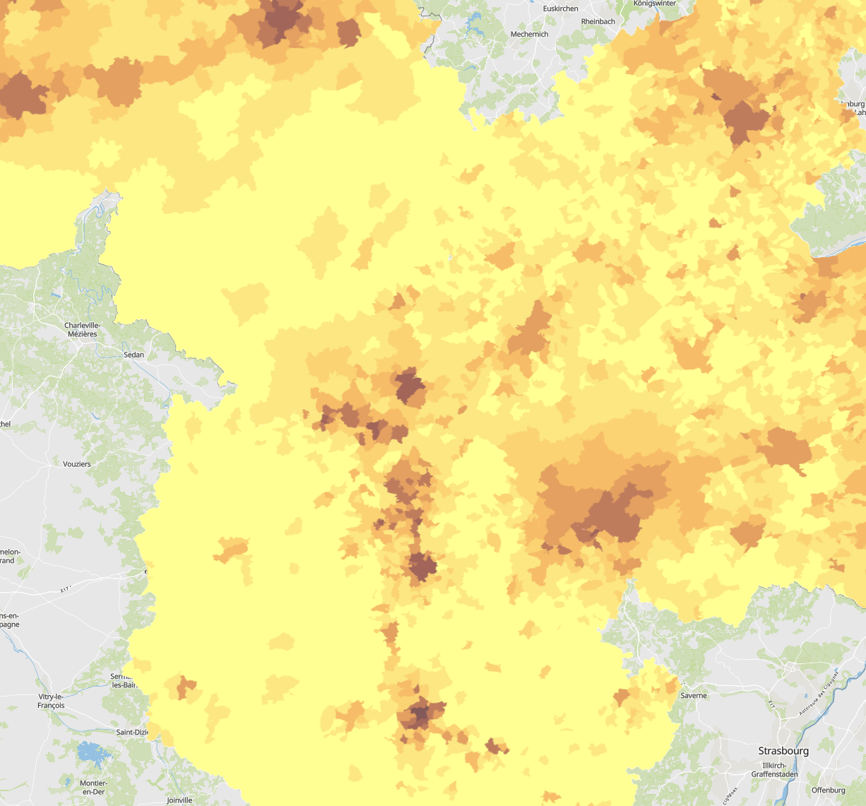
Population density 2024 per municipality
- Population density 2024 (inhabitants per km²) per municipality. Reference date: 01.01.2024 (Luxembourg and Wallonia), 31.12.2023 (Rhineland-Palatinate and Saarland), 01.01.2022 (Lorraine)
- Statistical data sources: DATer, INSEE Grand Est, IWEPS, Région Grand Est, STATEC, Statistisches Landesamt Rheinland-Pfalz, Statistisches Amt Saarland. Harmonization: SIG-GR / GIS-GR 2025
- Geodata sources: GeoBasis-DE / BKG, IGN France, NGI-Belgium, ACT Luxembourg. Harmonization: SIG-GR / GIS-GR 2025
Simple
- Date (Creation)
- 2025-06-12T00:00:00
- Identifier
- / 4ba433fb-6c1e-459f-89ca-a2914eedfdaa
- Presentation form
- Digital map
- Status
- Completed
- Maintenance and update frequency
- As needed
- Keywords
-
- Population, density, municipality
- Entités dans la Grande Région
-
- Greater Region
- gis-gr.eu themes
-
- Demography
- gis-gr.eu structure
-
- Demography>Population density
- Keywords
-
- gis-gr.eu
- Access constraints
- Other restrictions
- Spatial representation type
- Vector
- Denominator
- 250000
- Metadata language
- English
- Metadata language
- Deutsch
- Metadata language
- Français
- Character set
- UTF8
- Topic category
-
- Society
))
- Reference system identifier
- EPSG / http://www.opengis.net/def/crs/EPSG/0/3857
- Distribution format
-
-
JPEG
()
-
SHAPE
()
-
PDF
()
-
JPEG
()
- OnLine resource
- Interactive map ( WWW:LINK-1.0-http--samples )
- OnLine resource
-
Pop_density_2024
(
OGC:WMS-1.3.0-http-get-map
)
Pop_density_2024
- OnLine resource
-
Pop_density:Pop_density_2024
(
OGC:WFS
)
Pop_density_2024
- OnLine resource
- Open data ( WWW:LINK-1.0-http--link )
- File identifier
- 4ba433fb-6c1e-459f-89ca-a2914eedfdaa XML
- Metadata language
- Français
- Character set
- UTF8
- Hierarchy level
- Dataset
- Hierarchy level name
- dataset
- Date stamp
- 2025-07-07T12:12:41
- Metadata standard name
- ISO 19115:2003/19139
- Metadata standard version
- 1.0
Overviews
Spatial extent
Provided by
