 geocatalogue.geoportail.lu
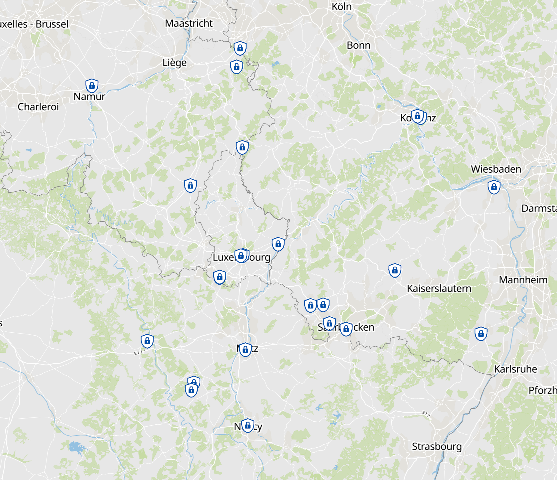
Calendrier 2025 de la Grande Région: sécurité, prévention et protection civile
Calendar 2025 of the Greater Region: Security, prevention and civil protection
Kalender 2025 der Großregion: Sicherheit, Prävention und Bevölkerungsschutz
- Calendrier 2025 de la Grande Région: sécurité, prévention et protection civile
- Données: Goupe de travail Cadastre et cartographie du Sommet de la Grande Région. Harmonisation: SIG-GR 2025
- Calendar 2025 of the Greater Region: Security, prevention and civil protection
- Data: Working party Land registry and mapping of the Summit of the Greater Region: Harmonization: GIS-GR 2025
- Kalender 2025 der Großregion: Sicherheit, Prävention und Bevölkerungsschutz
- Daten: Arbeitsgruppe Kataster und Kartographie der Großregion. Harmonisierung: GIS-GR 2025
Simple
-
Date (Creation)Datum (Erstellung)Date (Création)
- 2019-06-13T00:00:00
-
IdentifierIdentifikatorIdentificateur
- / 4a7270c1-696e-406d-9176-8d9ff0a1dcd1
-
Presentation formPräsentationsformForme de la présentation
-
Digital mapDigitale KarteCarte numérique
-
StatusBearbeitungsstatusEtat
-
CompletedAbgeschlossenFinalisé
- Keywords
-
-
Sécurité, préventionSecurity, preventionSicherheit, Prävention
-
-
Entités dans la Grande Région
-
-
Grande RégionGreater RegionGroßregion
-
-
gis-gr.eu themes
-
-
SécuritéSecuritySicherheit
-
-
gis-gr.eu structure
-
-
Sécurité>PréventionSecurity>PreventionSicherheit>Prävention
-
- Keywords
-
-
gis-gr.eugis-gr.eugis-gr.eu
-
-
Access constraintsZugriffseinschränkungenContraintes d'accès
-
Other restrictionsBenutzerdeifinierte EinschränkungenAutres restrictions
-
Spatial representation typeRäumliche DarstellungsartType de représentation spatiale
-
VectorVektorVecteur
-
DenominatorMassstabszahlDénominateur de l'échelle
- 250000
-
Metadata languageSpracheLangue
- Deutsch
-
Metadata languageSpracheLangue
- Français
-
Metadata languageSpracheLangue
- English
-
Character setZeichensatzJeu de caractères
-
UTF8Utf8Utf8
))
-
Maintenance and update frequencyÜberarbeitungsintervallFréquence de mise à jour
-
As neededBei BedarfLorsque nécessaire
-
Reference system identifierIdentifikator des ReferenzsystemsNom du système de référence
- EPSG / http://www.opengis.net/def/crs/EPSG/0/3857
-
Distribution formatAbgabeformatFormat (encodage)
-
-
SHAPE()
-
PDF()
-
JPEG()
-
-
OnLine resourceOnlineRessource en ligne
- Carte interactive Interactive map Interaktive Karte ( WWW:LINK-1.0-http--samples )
-
OnLine resourceOnlineRessource en ligne
- Open data ( WWW:LINK-1.0-http--link )
-
File identifierMetadatensatzidentifikatorIdentifiant de la fiche
- 4a7270c1-696e-406d-9176-8d9ff0a1dcd1 XML
-
Metadata languageSpracheLangue
- Français
-
Character setZeichensatzJeu de caractères
-
UTF8Utf8Utf8
-
Hierarchy levelHierarchieebeneType de ressource
-
DatasetDatenbestandJeu de données
- Hierarchy level name
- dataset
-
Date stampDatumDate des métadonnées
- 2025-04-22T09:42:42
- Metadata standard name
- ISO 19115:2003/19139
- Metadata standard version
- 1.0
Overviews
Spatial extent
Provided by
