 geocatalogue.geoportail.lu
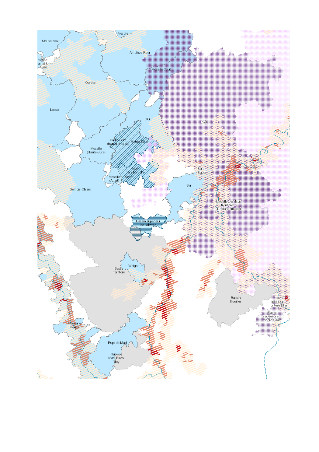
Aléa d'inondation et gestion des cours d'eau 2018
Flood hazard and water management 2018
Überschwemmungsgefährdung und Gewässerbewirtschaftung 2018
- Superficie de la commune soumise à l'aléa d'inondation (période de retour de 10 ans)
- contrats de rivière
- partenariats inondation
- SAGE
- A(l)qua
- Sources: SIG-GR / GIS-GR 2018; REEW 2017; Office International de l'Eau, Gest'eau 2015-2016; MDDI 2018; HPI-CIP 2015; IBH RLP 2018. Harmonisation: IGEAT 2018;
- Surface area of the municipality subject to flood risk (10-year return period)
- river contracts
- flood partnerships
- SAGE
- A(l)qua
- Sources: SIG-GR / GIS-GR 2018; REEW 2017; Office International de l'Eau, Gest'eau 2015-2016; MDDI 2018; HPI-CIP 2015; IBH RLP 2018. Harmonization: IGEAT 2018;
- Hochwassergefährdete Fläche der Gemeinde (10-jährige Wiederkehrperiode)
- Flussverträge
- Hochwasserpartnerschaften
- SAGE
- A(l)qua
- Quellen: SIG-GR / GIS-GR 2018; REEW 2017; Office International de l'Eau, Gest'eau 2015-2016; MDDI 2018; HPI-CIP 2015; IBH RLP 2018. Harmonisierung: IGEAT 2018;
Simple
-
Date (Creation)Datumsangaben (Erstellung)Date (Création)
- 2019-08-23T00:00:00
-
Citation identifierIdentifikatorIdentificateur
- / 165be34d-a0ac-42ff-ada7-d09a9b8f60ac
-
Presentation formPräsentationsformForme de la présentation
-
Digital mapDigitale KarteCarte numérique
-
StatusBearbeitungsstatusEtat
-
CompletedAbgeschlossenFinalisé
- Point of contact
-
Organisation name Individual name Electronic mail address Role SIG-GR - Ministère de l'Energie et de l'Aménagement du territoire - Département de l'aménagement du territoire
Thierry Hengen
AuthorAutorAuteur
-
Maintenance and update frequencyÜberarbeitungsintervallFréquence de mise à jour
-
As neededBei BedarfLorsque nécessaire
- Keywords
-
-
Eau, gestion, inondation
Water, management, flood
Wasser, Bewirtschaftung, Überschwemmung
-
-
Entités dans la Grande Région
-
-
Grande Région
Greater Region
Großregion
-
-
gis-gr.eu themes
-
-
Environnement
Environment
Umwelt
-
-
gis-gr.eu structure
-
-
Environnement>Réseau hydrographique
Environment>Waterway network
Umwelt>Gewässernetz
-
- Keywords
-
-
gis-gr.eu
gis-gr.eu
gis-gr.eu
-
-
Access constraintsZugriffseinschränkungenContraintes d'accès
-
Other restrictionsBenutzerdefinierte EinschränkungenAutres restrictions
-
Spatial representation typeRäumliche DarstellungsartType de représentation spatiale
-
VectorVektorVecteur
-
DenominatorMaßstabszahlDénominateur de l'échelle
- 250000
-
LanguageSpracheLangue de la ressource
- Deutsch
-
LanguageSpracheLangue de la ressource
- Français
-
LanguageSpracheLangue de la ressource
- English
-
Character setZeichensatzEncodage des caractères
-
UTF8Utf8Utf8
-
Topic categoryISO-ThematikCatégorie ISO
-
-
EnvironmentUmweltEnvironnement
-
Inland watersBinnengewässerEaux intérieures, Hydrographie
-
))
-
Reference system identifierIdentifikator des ReferenzsystemsNom du système de référence
- EPSG / http://www.opengis.net/def/crs/EPSG/0/3857
- Distribution format
-
Name Version JPEG
SHAPE
PDF
- OnLine resource
Metadata
-
File identifierMetadatensatzidentifikatorIdentifiant de la fiche
- 165be34d-a0ac-42ff-ada7-d09a9b8f60ac XML
-
Metadata languageSpracheLangue
- Français
-
Character setZeichensatzJeu de caractères
-
UTF8Utf8Utf8
-
Hierarchy levelHierarchieebeneType de ressource
-
DatasetDatenbestandJeu de données
- Hierarchy level name
-
dataset
-
Date stampDatumDate des métadonnées
- 2025-03-26T15:44:16
- Metadata standard name
-
ISO 19115:2003/19139
- Metadata standard version
-
1.0
- Metadata author
-
Organisation name Individual name Electronic mail address Role SIG-GR - Ministère de l'Energie et de l'Aménagement du territoire - Département de l'aménagement du territoire
Thierry Hengen
Point of contactAnsprechpartnerPoint de contact
- Other language
-
Language Character encoding EnglishEnglischAnglaisUTF8Utf8Utf8GermanDeutschAllemandUTF8Utf8Utf8FrenchFranzösischFrançaisUTF8Utf8Utf8
)))