• geocatalogue.geoportail.lu
  •   Search
  •   Map
  •  Sign in

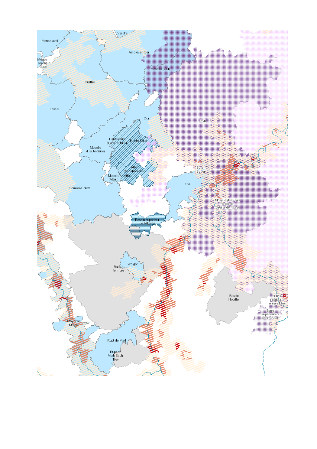
Flood hazard and water management 2018

- Surface area of the municipality subject to flood risk (10-year return period)

- river contracts

- flood partnerships

- SAGE

- A(l)qua


- Sources: SIG-GR / GIS-GR 2018; REEW 2017; Office International de l'Eau, Gest'eau 2015-2016; MDDI 2018; HPI-CIP 2015; IBH RLP 2018. Harmonization: IGEAT 2018;

Simple

Date (Creation)
2019-08-23T00:00:00
Citation identifier
/ 165be34d-a0ac-42ff-ada7-d09a9b8f60ac
Presentation form
Digital map
Status
Completed
Point of contact
Organisation name Individual name Electronic mail address Role

SIG-GR - Ministère de l'Energie et de l'Aménagement du territoire - Département de l'aménagement du territoire

Thierry Hengen

thierry.hengen@mat.etat.lu

Author
Maintenance and update frequency
As needed
Keywords
  • Water, management, flood

Entités dans la Grande Région

  • Greater Region

gis-gr.eu themes

  • Environment

gis-gr.eu structure

  • Environment>Waterway network

Keywords
  • gis-gr.eu

Access constraints
Other restrictions
Spatial representation type
Vector
Denominator
250000
Language
Deutsch
Language
Français
Language
English
Character set
UTF8
Topic category
  • Environment
  • Inland waters
N
S
E
W
thumbnail


Reference system identifier
EPSG / http://www.opengis.net/def/crs/EPSG/0/3857
Distribution format
Name Version

JPEG

SHAPE

PDF

OnLine resource
Protocol Linkage Name

WWW:LINK-1.0-http--samples

https://map.gis-gr.eu/theme/environnement?version=3&zoom=8&X=667917&Y=6394482&lang=fr&layers=1880&opacities=1

Interactive map

WWW:LINK-1.0-http--link

https://data.public.lu/en/datasets/flood-hazard-and-water-management-2018

Open data

OGC:WMS-1.3.0-http-get-map

https://ws.geoportail.lu/wss/service/GR_Hydrography_WMS/guest

International_partnerships_floods_2018

OGC:WMS-1.3.0-http-get-map

https://ws.geoportail.lu/wss/service/GR_Hydrography_WMS/guest

National_partnerships_floods_2018

OGC:WMS-1.3.0-http-get-map

https://ws.geoportail.lu/wss/service/GR_Hydrography_WMS/guest

navigable_waterways_2018

OGC:WMS-1.3.0-http-get-map

https://ws.geoportail.lu/wss/service/GR_Hydrography_WMS/guest

Project_Interreg_Alqua_2018

OGC:WMS-1.3.0-http-get-map

https://ws.geoportail.lu/wss/service/GR_Hydrography_WMS/guest

River_contracts_2018

OGC:WMS-1.3.0-http-get-map

https://ws.geoportail.lu/wss/service/GR_Hydrography_WMS/guest

GR/Flood_risk_water_management_2018/SAGE_LOR

OGC:WMS-1.3.0-http-get-map

https://ws.geoportail.lu/wss/service/GR_Hydrography_WMS/guest

surface_municipality_flood_risk_2018

OGC:WFS

https://ws.geoportail.lu/wss/service/GR_Hydrography_WFS/guest

Hydrography:International_partnerships_floods_2018

OGC:WFS

https://ws.geoportail.lu/wss/service/GR_Hydrography_WFS/guest

Hydrography:National_partnerships_floods_2018

OGC:WFS

https://ws.geoportail.lu/wss/service/GR_Hydrography_WFS/guest

Hydrography:Project_Interreg_Alqua_2018

OGC:WFS

https://ws.geoportail.lu/wss/service/GR_Hydrography_WFS/guest

Hydrography:River_contracts_2018

OGC:WFS

https://ws.geoportail.lu/wss/service/GR_Hydrography_WFS/guest

Hydrography:SAGE_LOR_2018

OGC:WFS

https://ws.geoportail.lu/wss/service/GR_Hydrography_WFS/guest

Hydrography:surface_municipality_flood_risk_2018

OGC:WFS

https://ws.geoportail.lu/wss/service/GR_Hydrography_WFS/guest

Hydrography:navigable_waterways_2018

Metadata

File identifier
165be34d-a0ac-42ff-ada7-d09a9b8f60ac XML
Metadata language
Français
Character set
UTF8
Hierarchy level
Dataset
Hierarchy level name

dataset

Date stamp
2025-03-26T15:44:16
Metadata standard name

ISO 19115:2003/19139

Metadata standard version

1.0

Metadata author
Organisation name Individual name Electronic mail address Role

SIG-GR - Ministère de l'Energie et de l'Aménagement du territoire - Département de l'aménagement du territoire

Thierry Hengen

thierry.hengen@mat.etat.lu

Point of contact
Other language
Language Character encoding
English UTF8
German UTF8
French UTF8


Overviews

overview

Spatial extent

thumbnail

Keywords

Water, management, flood
gis-gr.eu structure

Environment>Waterway network
gis-gr.eu themes

Environment


Provided by

logo
Access to the catalogue
Read here the full details and access to the data.


  •   About
  •   Github
  •