 geocatalogue.geoportail.lu
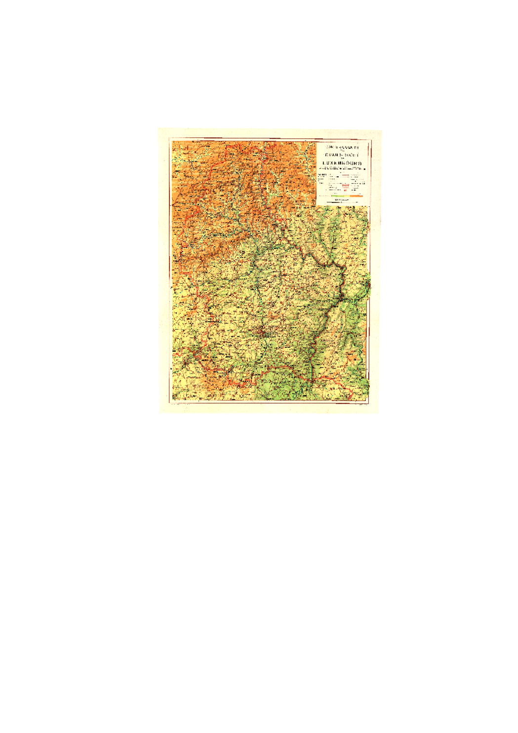
Carte topographique 1:150k 1950
Topografesch Kaart 1:150k 1950
Topographical Map 1:150k 1950
Topographische Karte 1:150k 1950
Carte topographique historique du Grand-Duché de Luxembourg pour l’enseignement scolaire, 1950 Editeur: Aloyse Linster Auteur: Kümmerly & Frey
Historesch topographesch Kaart vun Lëtzebuerg fir den Schoulunterrecht, 1950 Editeur: Aloyse Linster Auteur: Kümmerly & Frey
Historische topographische Karte Luxemburgs für den Schulunterricht, 1950 Editeur: Aloyse Linster Auteur: Kümmerly & Frey
Historic topographic map of Luxembourg for school teaching, 1950 Editeur: Aloyse Linster Auteur: Kümmerly & Frey
Simple
-
IdentificateurIdentificateurCitation identifierIdentifikator
- / f29901f2-c4b0-4250-a332-640e25a84d2e
-
Forme de la présentationForme de la présentationPresentation formPräsentationsform
-
Carte numériqueCarte numériqueDigital mapDigitale Karte
-
EtatEtatStatusBearbeitungsstatus
-
Mise à jour continueMise à jour continueOn goingKontinuierliche Aktualisierung
-
Fréquence de mise à jourFréquence de mise à jourMaintenance and update frequencyÜberarbeitungsintervall
-
Lorsque nécessaireLorsque nécessaireAs neededBei Bedarf
-
Entités au Grand-Duché de Luxembourg
-
-
Grand-Duché du Luxembourg
Grand-Duché du Luxembourg
Grand-Duché du Luxembourg
Grand-Duché du Luxembourg
-
- Keywords
-
-
carte, topographie, historique
Kaart, Topographie, historesch
Karte, Topographie, historisch
map, topography, historic
-
- Keywords
-
-
geoportail.lu
geoportail.lu
geoportail.lu
geoportail.lu
-
-
geoportail.lu themes
-
-
Tourisme
Tourismus
Tourism
Tourismus
-
Grand Public
Allgemeng
Main
Allgemein
-
-
geoportail.lu structure
-
-
Tourisme>Cartes topographiques>Cartes topographiques historiques
Tourisme>Cartes topographiques>Cartes topographiques historiques>Historësch topografesch Kaarten
Tourism>Topographical maps>Historical topographical Maps
Tourismus>Topographische Karten>Historische topographische Karten
-
Grand Public>Données de base>Cartes topographiques>Cartes topographiques historiques
Grand Public>Données de base>Cartes topographiques>Cartes topographiques historiques>Historësch topografesch Kaarten
Main>Geographical location>Topographical maps>Historical topographical Maps
Allgemein>Basisdaten>Topographische Karten>Historische topographische Karten
-
-
Contraintes d'accèsContraintes d'accèsAccess constraintsZugriffseinschränkungen
-
Autres restrictionsAutres restrictionsOther restrictionsBenutzerdefinierte Einschränkungen
-
Type de représentation spatialeType de représentation spatialeSpatial representation typeRäumliche Darstellungsart
-
VecteurVecteurVectorVektor
-
Dénominateur de l'échelleDénominateur de l'échelleDenominatorMaßstabszahl
- 0
-
Encodage des caractèresEncodage des caractèresCharacter setZeichensatz
-
Utf8Utf8UTF8Utf8
))
-
Nom du système de référenceNom du système de référenceReference system identifierIdentifikator des Referenzsystems
- EPSG / http://www.opengis.net/def/crs/EPSG/0/2169
- OnLine resource
-
Protocol Linkage Name OGC:WMS-1.3.0-http-get-map
https://wms.geoportail.lu/public_map_layers/service 810
810
810
810
https://map.geoportail.lu/theme/main?version=3&zoom=8&X=667917&Y=6394482&lang=fr&layers=810&opacities=1 Carte topographique 1:150k 1950
Topografesch Kaart 1:150k 1950
Topographical Map 1:150k 1950
Topographische Karte 1:150k 1950
Metadata
-
Identifiant de la ficheIdentifiant de la ficheFile identifierMetadatensatzidentifikator
- f29901f2-c4b0-4250-a332-640e25a84d2e XML
-
LangueLangueMetadata languageSprache
- Français
-
Jeu de caractèresJeu de caractèresCharacter setZeichensatz
-
Utf8Utf8UTF8Utf8
-
Type de ressourceType de ressourceHierarchy levelHierarchieebene
-
Jeu de donnéesJeu de donnéesDatasetDatenbestand
- Hierarchy level name
-
dataset
-
Date des métadonnéesDate des métadonnéesDate stampDatum
- 2021-02-04T22:35:46
- Metadata standard name
-
ISO 19115:2003/19139
- Metadata standard version
-
1.0
- Metadata author
-
Organisation name Individual name Electronic mail address Role Administration du Cadastre et de la Topographie
Administration du Cadastre et de la Topographie
Point de contactPoint de contactPoint of contactAnsprechpartner
- Other language
-
Language Character encoding FrançaisFranséischFrenchFranzösischUtf8Utf8UTF8Utf8LuxembourgeoisLëtzebuergeschLuxembourgish; LetzeburgeschLuxemburgischUtf8Utf8UTF8Utf8AnglaisEngleschEnglishEnglischUtf8Utf8UTF8Utf8AllemandDäitschGermanDeutschUtf8Utf8UTF8Utf8
)))