 geocatalogue.geoportail.lu
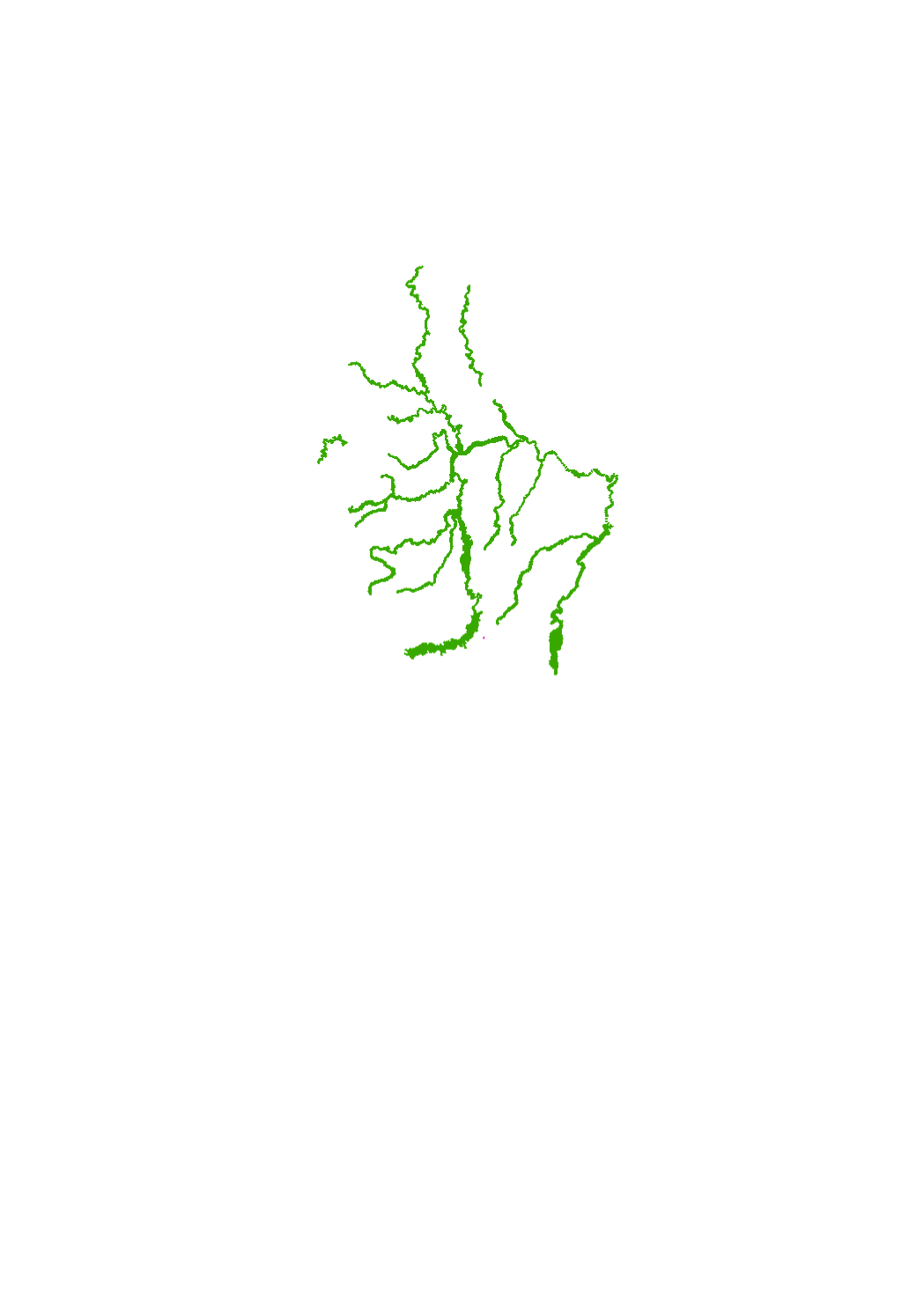
Profils en travers
Querprofiler
Cross sections
Querprofile
Il s'agit de profils en travers qui ont été pris tous les 100m à travers les quinze cours d'eau TIMIS.
Et handelt sech ëm Querprofiler déi an den fofzéng TIMIS Gewässer all 100m opgeholl sinn ginn.
These are cross sections that where taken every 100m for the fifteen TIMIS rivers.
Es handelt sich um Querprofile die in den fünftzehn TIMIS Gewässern alle 100m erstellt worden sind.
Simple
-
Date (Révision)Date (Revision)Datumsangaben (Überarbeitung)Date (Révision)
- 2013-12-01T00:00:00
-
IdentificateurCitation identifierIdentifikatorIdentificateur
- / e308bb4d-3d06-4fb3-959a-ee54537a5689
-
Forme de la présentationPresentation formPräsentationsformForme de la présentation
-
Carte numériqueDigital mapDigitale KarteCarte numérique
-
EtatStatusBearbeitungsstatusEtat
-
Mise à jour continueOn goingKontinuierliche AktualisierungMise à jour continue
- Point of contact
-
Organisation name Individual name Electronic mail address Role Administration de la gestion de l'eau
Division de l'hydrologie
Point de contactPoint of contactAnsprechpartnerPoint de contact
-
Fréquence de mise à jourMaintenance and update frequencyÜberarbeitungsintervallFréquence de mise à jour
-
Lorsque nécessaireAs neededBei BedarfLorsque nécessaire
-
Entités au Grand-Duché de Luxembourg
-
-
Grand-Duché du Luxembourg
Grand-Duché du Luxembourg
Grand-Duché du Luxembourg
Grand-Duché du Luxembourg
-
- Keywords
-
- Keywords
-
-
profils en travers
Querprofiler
Cross sections
Querprofile
-
intranet
intranet
intranet
intranet
-
-
geoportail.lu themes
-
-
Eau
Wasser
Water
Wasser
-
Lenoz
Lenoz
Lenoz
Lenoz
-
Grand Public
Allgemeng
Main
Allgemein
-
-
geoportail.lu structure
-
-
Eau>Directive inondation [DI]>Informations supplémentaires
Eau>Directive inondation [DI]>Informations supplémentaires>Zousätzlech Informatiounen
Water>Floods directive [FD]>Additional Informations
Wasser>Hochwasserrisikomanagement-Richtlinie [HWRM-RL]>Zusätzliche Informationen
-
Lenoz>Directive inondation [DI]>Informations supplémentaires
Lenoz>Directive inondation [DI]>Informations supplémentaires>Zousätzlech Informatiounen
Lenoz>Floods directive [FD]>Additional Informations
Lenoz>Hochwasserrisikomanagement-Richtlinie [HWRM-RL]>Zusätzliche Informationen
-
Grand Public>Environnement, biologie et géologie>Directive inondation [DI]>Informations supplémentaires
Grand Public>Environnement, biologie et géologie>Directive inondation [DI]>Informations supplémentaires>Zousätzlech Informatiounen
Main>Environment, Biology and Geology>Floods directive [FD]>Additional Informations
Allgemein>Umwelt, Biologie und Geologie>Hochwasserrisikomanagement-Richtlinie [HWRM-RL]>Zusätzliche Informationen
-
-
Contraintes d'utilisationUse constraintsNutzungseinschränkungenContraintes d'utilisation
-
Autres restrictionsOther restrictionsBenutzerdefinierte EinschränkungenAutres restrictions
- Other constraints
-
Creative Commons 1.0 Universal (CC0 1.0) Public Domain Dedication
-
Type de représentation spatialeSpatial representation typeRäumliche DarstellungsartType de représentation spatiale
-
VecteurVectorVektorVecteur
-
Dénominateur de l'échelleDenominatorMaßstabszahlDénominateur de l'échelle
- 0
-
Langue de la ressourceLanguageSpracheLangue de la ressource
- Deutsch
-
Encodage des caractèresCharacter setZeichensatzEncodage des caractères
-
Utf8UTF8Utf8Utf8
-
Catégorie ISOTopic categoryISO-ThematikCatégorie ISO
-
-
EnvironnementEnvironmentUmweltEnvironnement
-
Sciences de la terre, géosciencesGeoscientific informationGeowissenschaftenSciences de la terre, géosciences
-
Eaux intérieures, HydrographieInland watersBinnengewässerEaux intérieures, Hydrographie
-
))
-
Nom du système de référenceReference system identifierIdentifikator des ReferenzsystemsNom du système de référence
- EPSG / http://www.opengis.net/def/crs/EPSG/0/2169
- Distribution format
-
Name Version DXF
PDF
- OnLine resource
-
Protocol Linkage Name WWW:LINK-1.0-http--link
https://data.public.lu/fr/datasets/cross-sections/
- OnLine resource
-
Protocol Linkage Name https://map.geoportail.lu/theme/main?version=3&zoom=8&X=667917&Y=6394482&lang=fr&layers=584&opacities=1 Profils en travers 2013
Querprofiler 2013
Cross sections 2013
Querprofile 2013
- Statement
-
Issus du projet Interreg III B TIMIS flood (Transnational Internet Map Information System on Flooding) ainsi que de projets de renaturation réalisés depuis 2009 et de compagnes de mesures réalisées en 2011 dans le cadre de l'établissement des cartes des zones inondables
Metadata
-
Identifiant de la ficheFile identifierMetadatensatzidentifikatorIdentifiant de la fiche
- e308bb4d-3d06-4fb3-959a-ee54537a5689 XML
-
LangueMetadata languageSpracheLangue
- Français
-
Jeu de caractèresCharacter setZeichensatzJeu de caractères
-
Utf8UTF8Utf8Utf8
-
Type de ressourceHierarchy levelHierarchieebeneType de ressource
-
Jeu de donnéesDatasetDatenbestandJeu de données
- Hierarchy level name
-
dataset
-
Date des métadonnéesDate stampDatumDate des métadonnées
- 2024-06-25T12:18:08
- Metadata standard name
-
ISO 19115:2003/19139
- Metadata standard version
-
1.0
- Metadata author
-
Organisation name Individual name Electronic mail address Role Administration de la gestion de l'eau
Division de l'hydrologie
Point de contactPoint of contactAnsprechpartnerPoint de contact
- Other language
-
Language Character encoding LëtzebuergeschLuxembourgish; LetzeburgeschLuxemburgischLuxembourgeoisUtf8UTF8Utf8Utf8EngleschEnglishEnglischAnglaisUtf8UTF8Utf8Utf8DäitschGermanDeutschAllemandUtf8UTF8Utf8Utf8FranséischFrenchFranzösischFrançaisUtf8UTF8Utf8Utf8
)))