 geocatalogue.geoportail.lu
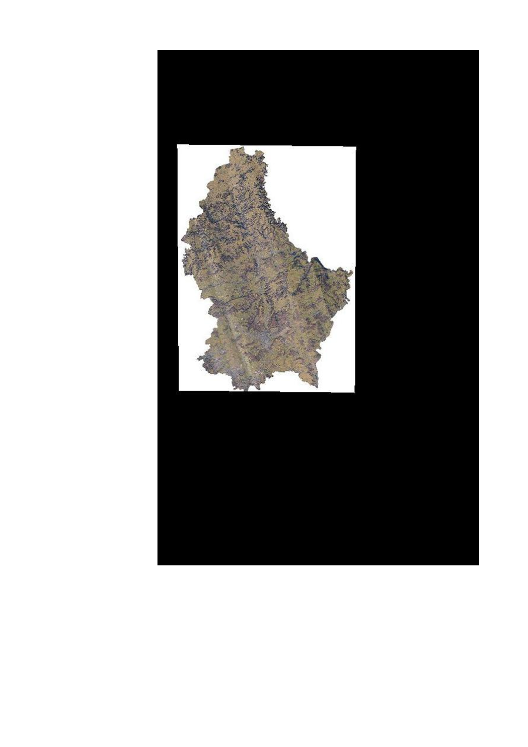
Orthophoto technique (hiver 2019)
Technësch Orthophoto (Wanter 2019)
Technical orthophoto (winter 2019)
Technisches Orthophoto (Winter 2019)
Mi-février 2019, l'ACT a réalisé un survol LiDAR pour tout le pays. Cette orthophoto, qui est primairement à vocation technique, est issue de ce survol.
Am Februar 2019 huet de Kadaster eng landeswäit LIDAR Iwwerfléiung duerchgefouert. Dës Orthophoto ass zesummen mat der LiDAR Iwwerfléiung zu technëschen Zwecker opgeholl gin.
In february 2019, the ACT has executed a LIDAR flight for the whole country. Issued from the same flight, this aerial image (orthophoto) is primary for technical use.
Im Februar 2019 hat die Katasterverwaltung eine landesweite LiDAR - Überfliegung durchgeführt. Dieses Luftbild (Orthophoto) stammt aus derselben Überfliegung und hat primär technische Zwecke.
Simple
-
IdentificateurCitation identifierIdentifikatorIdentificateur
- / d6cc500f-b802-4be2-a49c-73f3eb2d131e
-
Forme de la présentationPresentation formPräsentationsformForme de la présentation
-
Carte numériqueDigital mapDigitale KarteCarte numérique
-
EtatStatusBearbeitungsstatusEtat
-
Mise à jour continueOn goingKontinuierliche AktualisierungMise à jour continue
- Point of contact
-
Organisation name Individual name Electronic mail address Role Administration du Cadastre et de la Topographie
Administration du Cadastre et de la Topographie
Point de contactPoint of contactAnsprechpartnerPoint de contact
-
Fréquence de mise à jourMaintenance and update frequencyÜberarbeitungsintervallFréquence de mise à jour
-
Lorsque nécessaireAs neededBei BedarfLorsque nécessaire
-
Entités au Grand-Duché de Luxembourg
-
-
Grand-Duché du Luxembourg
Grand-Duché du Luxembourg
Grand-Duché du Luxembourg
Grand-Duché du Luxembourg
-
- Keywords
-
-
LiDAR, Orthophoto, Orthophoto technique, image aérienne, hiver, 2019
LiDAR, Orthophoto, Wanter, 2019, Loftbild, technesch Orthophoto
LiDAR, orthophoto, technical orthophoto, aerial image, winter, 2019
LiDAR, Orthophoto, technisches Orthophoto, Luftbild, Winter, 2019
-
- Keywords
-
-
geoportail.lu
geoportail.lu
geoportail.lu
geoportail.lu
-
- Keywords
-
-
geoportail.lu themes
-
-
Grand Public
Allgemeng
Main
Allgemein
-
Eau
Wasser
Water
Wasser
-
-
geoportail.lu structure
-
-
Grand Public>Modèles altimétriques numériques (BD-L-LiDAR)>LiDAR 2019
Grand Public>Modèles altimétriques numériques (BD-L-LiDAR)>LiDAR 2019>LiDAR 2019
Main>Digital elevation model (BD-L-LiDAR)>LiDAR 2019
Allgemein>Digitales Höhenmodell (BD-L-LiDAR)>LiDAR 2019
-
Grand Public>Couverture du sol>Images aériennes et satellites
Grand Public>Couverture du sol>Images aériennes et satellites>Loft- a Satellitebiller
Main>Land surface>Orthophoto-images
Allgemein>Oberflächendarstellung>Luft und Satellitenbilder
-
Eau>Données de base>Photographies aériennes et spatiales
Eau>Données de base>Photographies aériennes et spatiales>Loft- an Satellitebiller
Water>Geographical location>Aerial and satellite photographs
Wasser>Basisdaten>Luft- und Satellitenbilder
-
Grand Public>Couverture du sol>Modèles altimétriques numériques (BD-L-LiDAR)>LiDAR 2019
Grand Public>Couverture du sol>Modèles altimétriques numériques (BD-L-LiDAR)>LiDAR 2019>LiDAR 2019
Main>Land surface>Digital elevation model (BD-L-LiDAR)>LiDAR 2019
Allgemein>Oberflächendarstellung>Digitales Höhenmodell (BD-L-LiDAR)>LiDAR 2019
-
-
Contraintes d'utilisationUse constraintsNutzungseinschränkungenContraintes d'utilisation
-
Autres restrictionsOther restrictionsBenutzerdefinierte EinschränkungenAutres restrictions
- Other constraints
-
Creative Commons 1.0 Universal (CC0 1.0) Public Domain Dedication
-
Type de représentation spatialeSpatial representation typeRäumliche DarstellungsartType de représentation spatiale
-
VecteurVectorVektorVecteur
-
Dénominateur de l'échelleDenominatorMaßstabszahlDénominateur de l'échelle
- 0
-
Encodage des caractèresCharacter setZeichensatzEncodage des caractères
-
Utf8UTF8Utf8Utf8
))
-
Nom du système de référenceReference system identifierIdentifikator des ReferenzsystemsNom du système de référence
- EPSG / http://www.opengis.net/def/crs/EPSG/0/2169
- OnLine resource
-
Protocol Linkage Name OGC:WMS-1.3.0-http-get-map
https://wms.geoportail.lu/public_map_layers/service 1789
1789
1789
1789
WWW:LINK-1.0-http--link
https://data.public.lu/fr/datasets/orthophoto-technique-du-grand-duche-de-luxembourg-edition-2019-hiver/
- OnLine resource
-
Protocol Linkage Name https://map.geoportail.lu/theme/main?version=3&zoom=8&X=667917&Y=6394482&lang=fr&layers=1789&opacities=1 Orthophoto 2019 (hiver)
Orthophoto 2019 (Wanter)
Orthophoto 2019 (winter)
Orthophoto 2019 (Winter)
Metadata
-
Identifiant de la ficheFile identifierMetadatensatzidentifikatorIdentifiant de la fiche
- d6cc500f-b802-4be2-a49c-73f3eb2d131e XML
-
LangueMetadata languageSpracheLangue
- Français
-
Jeu de caractèresCharacter setZeichensatzJeu de caractères
-
Utf8UTF8Utf8Utf8
-
Type de ressourceHierarchy levelHierarchieebeneType de ressource
-
Jeu de donnéesDatasetDatenbestandJeu de données
- Hierarchy level name
-
dataset
-
Date des métadonnéesDate stampDatumDate des métadonnées
- 2022-07-27T09:51:07
- Metadata standard name
-
ISO 19115:2003/19139
- Metadata standard version
-
1.0
- Metadata author
-
Organisation name Individual name Electronic mail address Role Administration du Cadastre et de la Topographie
Administration du Cadastre et de la Topographie
Point de contactPoint of contactAnsprechpartnerPoint de contact
- Other language
-
Language Character encoding LëtzebuergeschLuxembourgish; LetzeburgeschLuxemburgischLuxembourgeoisUtf8UTF8Utf8Utf8EngleschEnglishEnglischAnglaisUtf8UTF8Utf8Utf8DäitschGermanDeutschAllemandUtf8UTF8Utf8Utf8FranséischFrenchFranzösischFrançaisUtf8UTF8Utf8Utf8
)))