 geocatalogue.geoportail.lu
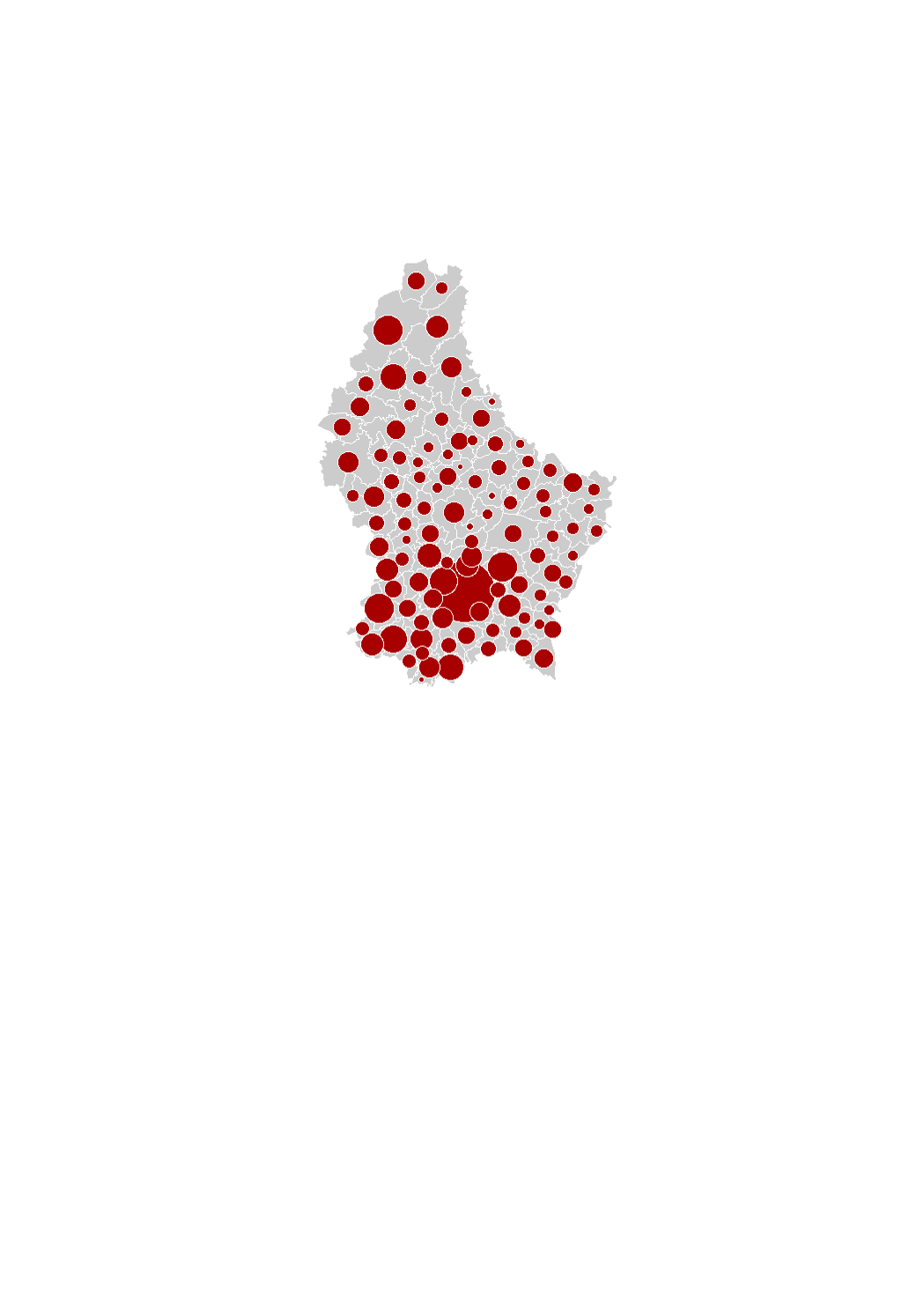
Superficie disponible (2016)
Verfügbar Fläch (2016)
Available land area (2016)
Verfügbare Fläche (2016)
Le potentiel foncier pour l'habitat correspond à toutes les surfaces disponibles au sein de l'ensemble des zones d'habitation et dans 75% des zones mixtes des plans d'aménagement général (PAG) des communes (en hectares). Il s'agit d'un potentiel théorique, indépendant de la volonté du propriétaire de le valoriser. Les sources de données sont le plan cadastral numérisé et la photographie aérienne provenant de l'Administration du Cadastre et de la Topographie de même que les PAG et PAP des communes recensés en collaboration avec le Ministère de l'Intérieur.
D'potenziellt Wunnbauland entsprécht sämtleche Flächen, déi innerhalb vun de Wunnzonen, souwéi 75% vun de Flächen, déi an de gemëschten Zonen an den allgemenge Bebauungspläng (PAG) vun de Gemenge fräi sinn (an Hektar). Et handelt sech heibäi ëm een theoretescht Potenzial, onofhängeg dovunner, ob de Besëtzer den Terrain valoriséiere wëll. Als Dategrondlag sinn déi digitaliséiert Kadasterparzellen an d'Loftbild vun der nationaler Kadaster- an Topographieverwaltung benotzt ginn, sou wéi och d'PAGen an d'PAPe vun de Gemengen, déi an Zesummenaarbecht mam Inneministère digitaliséiert gi sinn.
The land available for housing corresponds to all the vacant land within the residential areas and to 75% of vacant land within the mixed-used areas in the municipalities' general land use plans (PAG) (in hectares). This is a theoretical potential, independently of the will of the owners to develop the land. The data sources are the digitalized cadastral parcels and the orthophoto-images from the "Administration du Cadastre et de la Topographie", as well as the PAG and PAP of the municipalities digitalized in collaboration with the Ministry of Interior.
Das Flächenpotenzial für Wohnbauland entspricht sämtlichen freien Flächen innerhalb der reinen Wohngebiete sowie 75% der freien Flächen innerhalb der Mischgebiete in den allgemeinen Flächennutzungsplänen (PAG) der Gemeinden (in Hektar). Es handelt sich hierbei um ein theoretisches Potenzial, unabhängig vom Willen der Eigentümer, das Bauland zu entwickeln. Als Datengrundlage dienen die digitalisierten Katasterparzellen und das Luftbild der nationalen Kataster- und Topographieverwaltung, sowie die PAGs und PAPs der Gemeinden, die in Zusammenarbeit mit dem Innenministerium erfasst wurden.
Simple
-
IdentificateurIdentificateurCitation identifierIdentifikator
- / c3fb1ec8-10d3-4e2b-9272-bb0a7396cdb5
-
Forme de la présentationForme de la présentationPresentation formPräsentationsform
-
Carte numériqueCarte numériqueDigital mapDigitale Karte
-
EtatEtatStatusBearbeitungsstatus
-
Mise à jour continueMise à jour continueOn goingKontinuierliche Aktualisierung
- Point of contact
-
Organisation name Individual name Electronic mail address Role LISER
Observatoire de l'Habitat du Ministère du Logement
Point de contactPoint de contactPoint of contactAnsprechpartner
-
Fréquence de mise à jourFréquence de mise à jourMaintenance and update frequencyÜberarbeitungsintervall
-
Lorsque nécessaireLorsque nécessaireAs neededBei Bedarf
-
Entités au Grand-Duché de Luxembourg
-
-
Grand-Duché du Luxembourg
Grand-Duché du Luxembourg
Grand-Duché du Luxembourg
Grand-Duché du Luxembourg
-
- Keywords
-
- Keywords
-
-
potentiel foncier
potenziellt Wunnbauland
available land area
Flächenpotenzial
-
surface disponible
verfügbar Fläch
residential land
verfügbare Fläche
-
habitat
Wohnbauland
-
geoportail.lu
geoportail.lu
geoportail.lu
geoportail.lu
-
-
geoportail.lu themes
-
-
Logement
Wunnengsbau
Housing
Wohnungsbau
-
-
geoportail.lu structure
-
-
Logement>Potentiel foncier pour l'habitat
Logement>Potentiel foncier pour l'habitat>Potenziellt Wunnbauland
Housing>Land available for housing
Wohnungsbau>Flächenpotenzial für Wohnbauland
-
-
Contraintes d'utilisationContraintes d'utilisationUse constraintsNutzungseinschränkungen
-
Autres restrictionsAutres restrictionsOther restrictionsBenutzerdefinierte Einschränkungen
- Other constraints
-
Creative Commons 1.0 Universal (CC0 1.0) Public Domain Dedication
-
Type de représentation spatialeType de représentation spatialeSpatial representation typeRäumliche Darstellungsart
-
VecteurVecteurVectorVektor
-
Dénominateur de l'échelleDénominateur de l'échelleDenominatorMaßstabszahl
- 0
-
Encodage des caractèresEncodage des caractèresCharacter setZeichensatz
-
Utf8Utf8UTF8Utf8
))
-
Nom du système de référenceNom du système de référenceReference system identifierIdentifikator des Referenzsystems
- EPSG / http://www.opengis.net/def/crs/EPSG/0/2169
- OnLine resource
-
Protocol Linkage Name OGC:WMS-1.3.0-http-get-map
https://wms.geoportail.lu/public_map_layers/service 1744
1744
1744
1744
WWW:LINK-1.0-http--link
https://data.public.lu/fr/datasets/superficie-des-terrains-disponibles-pour-lhabitat-en-2016/
- OnLine resource
-
Protocol Linkage Name https://map.geoportail.lu/theme/main?version=3&zoom=8&X=667917&Y=6394482&lang=fr&layers=1744&opacities=1 Superficie disponible (2016)
Verfügbar Fläch (2016)
Available land area (2016)
Verfügbare Fläche (2016)
Metadata
-
Identifiant de la ficheIdentifiant de la ficheFile identifierMetadatensatzidentifikator
- c3fb1ec8-10d3-4e2b-9272-bb0a7396cdb5 XML
-
LangueLangueMetadata languageSprache
- Français
-
Jeu de caractèresJeu de caractèresCharacter setZeichensatz
-
Utf8Utf8UTF8Utf8
-
Type de ressourceType de ressourceHierarchy levelHierarchieebene
-
Jeu de donnéesJeu de donnéesDatasetDatenbestand
- Hierarchy level name
-
dataset
-
Date des métadonnéesDate des métadonnéesDate stampDatum
- 2021-02-04T23:50:51
- Metadata standard name
-
ISO 19115:2003/19139
- Metadata standard version
-
1.0
- Metadata author
-
Organisation name Individual name Electronic mail address Role LISER
Observatoire de l'Habitat du Ministère du Logement
Point de contactPoint de contactPoint of contactAnsprechpartner
- Other language
-
Language Character encoding FrançaisFranséischFrenchFranzösischUtf8Utf8UTF8Utf8LuxembourgeoisLëtzebuergeschLuxembourgish; LetzeburgeschLuxemburgischUtf8Utf8UTF8Utf8AnglaisEngleschEnglishEnglischUtf8Utf8UTF8Utf8AllemandDäitschGermanDeutschUtf8Utf8UTF8Utf8
)))