 geocatalogue.geoportail.lu
Mullerthal Trail
Mullerthal Trail
Mullerthal Trail
Mullerthal Trail
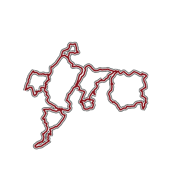
Cette couche contient les trois "Routes" et les quatre "ExtraTours" du Mullerthal Trail (certifié en tant que leading Quality Trail).
Dëse Layer enthält déi dräi Routen a véier ExtraTouren vum Mëllerdall Trail (zertifizéiert als Leading Quality Trail).
This layer contains the three routes and four ExtraTours of the Mullerthal Trail (certified as Leading Quality Trail).
Dieser Layer enthält die drei Routen und vier ExtraTouren des Mullerthal Trails (zertifiziert als Leading Quality Trail).
Simple
-
Date (Création)Date (Creation)Datumsangaben (Erstellung)Date (Création)
- Invalid DateT00:00:00
-
Date (Révision)Date (Revision)Datumsangaben (Überarbeitung)Date (Révision)
-
IdentificateurCitation identifierIdentifikatorIdentificateur
- / 8a11d9b4-2274-4505-8b03-ff9f075d7470
-
Forme de la présentationPresentation formPräsentationsformForme de la présentation
-
Carte numériqueDigital mapDigitale KarteCarte numérique
-
EtatStatusBearbeitungsstatusEtat
-
Mise à jour continueOn goingKontinuierliche AktualisierungMise à jour continue
- Point of contact
-
Organisation name Individual name Electronic mail address Role Administration du Cadastre et de la Topographie
Administration du Cadastre et de la Topographie
AuteurAuthorAutorAuteur
-
Fréquence de mise à jourMaintenance and update frequencyÜberarbeitungsintervallFréquence de mise à jour
-
Lorsque nécessaireAs neededBei BedarfLorsque nécessaire
-
Entités au Grand-Duché de Luxembourg
-
-
Grand-Duché du Luxembourg
Grand-Duché du Luxembourg
Grand-Duché du Luxembourg
Grand-Duché du Luxembourg
-
- Keywords
-
-
Mullerthal Trail, Leading Quality Trail, randonnée, tourisme
Mullerthal Trail, Leading Quality Trail, wanderen, Tourismus
Mullerthal Trail, Leading Quality Trail, hiking, tourism
Mullerthal Trail, Leading Quality Trail, Wandern, Tourismus
-
-
Geoportail.lu themes
-
-
Tourisme
Tourismus
Tourism
Tourismus
-
-
Geoportail.lu structure
-
-
Tourisme>Sentiers de randonnée>Randonnées phares
Tourismus>Wanderweeër>Wander-Highlights
Tourism>Hiking>Hiking Highlights
Tourismus>Wandern>Wander-Highlights
-
- Keywords
-
-
geoportail.lu
geoportail.lu
geoportail.lu
geoportail.lu
-
-
Contraintes d'accèsAccess constraintsZugriffseinschränkungenContraintes d'accès
-
Autres restrictionsOther restrictionsBenutzerdefinierte EinschränkungenAutres restrictions
-
Type de représentation spatialeSpatial representation typeRäumliche DarstellungsartType de représentation spatiale
-
VecteurVectorVektorVecteur
-
Dénominateur de l'échelleDenominatorMaßstabszahlDénominateur de l'échelle
- 500
-
Encodage des caractèresCharacter setZeichensatzEncodage des caractères
-
Utf8UTF8Utf8Utf8
))
-
Nom du système de référenceReference system identifierIdentifikator des ReferenzsystemsNom du système de référence
- EPSG / http://www.opengis.net/def/crs/EPSG/0/2169
- Distribution format
-
Name Version ShapefileTODO
- OnLine resource
-
Protocol Linkage Name OGC:WMS-1.3.0-http-get-map
https://wms.geoportail.lu/public_map_layers/service 189
UKST
https://map.geoportail.lu/theme/tourisme?version=3&zoom=10&X=668070&Y=6394482&lang=de&rotation=0&layers=189&opacities=1&time=&bgLayer=basemap_2015_global Mullerthal Trail
Mullerthal Trail
Mullerthal Trail
Mullerthal Trail
WWW:LINK-1.0-http--link
https://data.public.lu/fr/datasets/sentiers-de-randonnee-mullerthal-trail/ Mullerthal Trail
Mullerthal Trail
Mullerthal Trail
Mullerthal Trail
-
NiveauHierarchy levelBezugsebeneNiveau
-
Jeu de donnéesDatasetDatenbestandJeu de données
Metadata
-
Identifiant de la ficheFile identifierMetadatensatzidentifikatorIdentifiant de la fiche
- be71ab82-8930-4da7-840d-a99374312093 XML
-
LangueMetadata languageSpracheLangue
- Français
-
Jeu de caractèresCharacter setZeichensatzJeu de caractères
-
Utf8UTF8Utf8Utf8
-
Type de ressourceHierarchy levelHierarchieebeneType de ressource
-
Jeu de donnéesDatasetDatenbestandJeu de données
- Hierarchy level name
-
dataset
-
Date des métadonnéesDate stampDatumDate des métadonnées
- 2024-07-26T06:33:09
- Metadata standard name
-
ISO 19115:2003/19139
- Metadata standard version
-
1.0
- Metadata author
-
Organisation name Individual name Electronic mail address Role Office Régional du Tourisme Région Mullerthal - Petite Suisse Luxembourgeoise asbl
- Other language
-
Language Character encoding LëtzebuergeschLuxembourgish; LetzeburgeschLuxemburgischLuxembourgeoisUtf8UTF8Utf8Utf8EngleschEnglishEnglischAnglaisUtf8UTF8Utf8Utf8DäitschGermanDeutschAllemandUtf8UTF8Utf8Utf8FranséischFrenchFranzösischFrançaisUtf8UTF8Utf8Utf8
)))