 geocatalogue.geoportail.lu
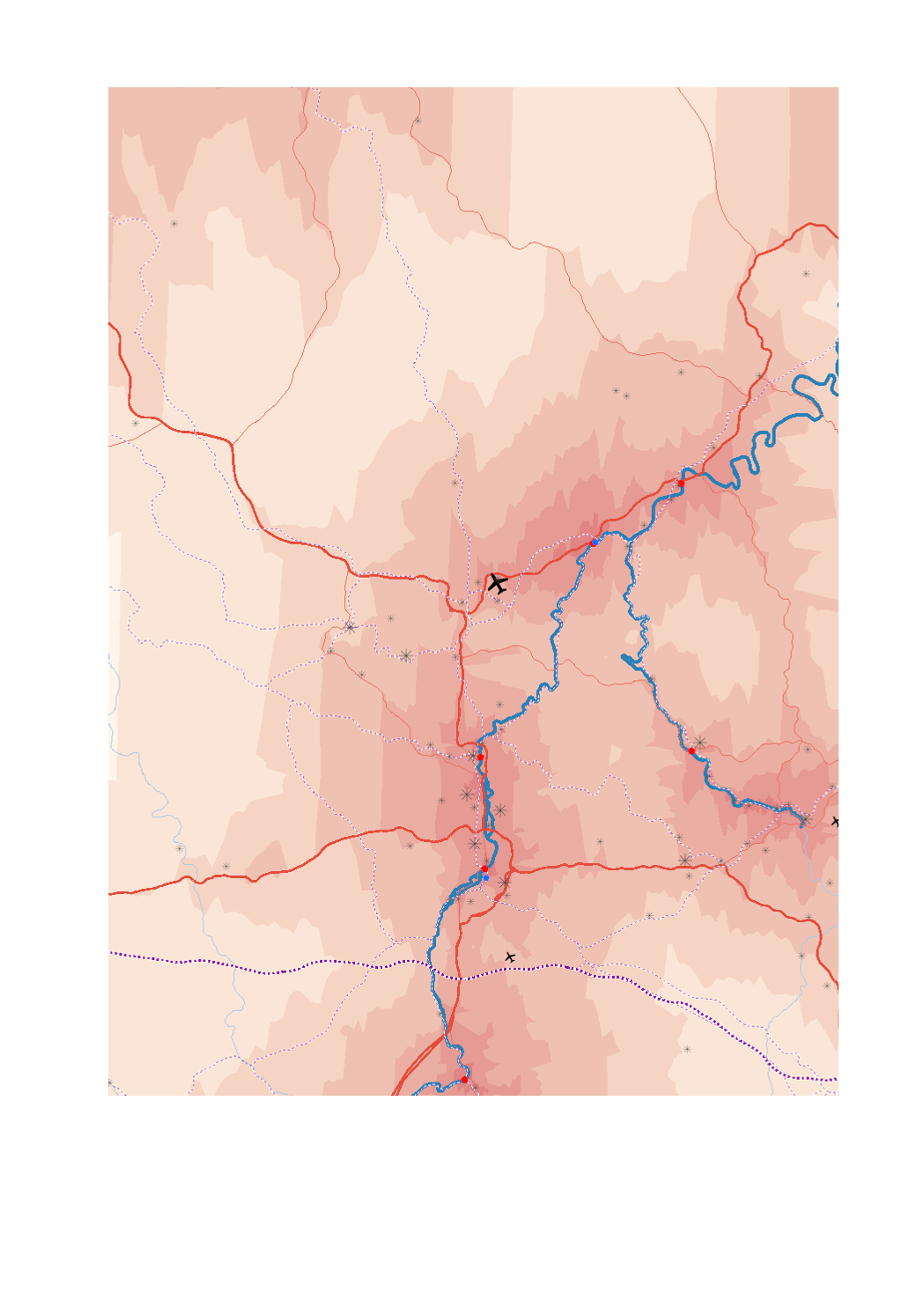
Infrastructures pour le transport de marchandises en 2018: échelle suprarégionale
Supraregional freight infrastructure 2018
Infrastrukturen für den Güterverkehr 2018: überregionale Ebene
- Trafic de fret (en tonnes) par aéroport en 2017
- Plateformes trimodales fluviale-route-ferroviaire
- Ports RTE-T
- Aire d'entrepôts commerciaux et industriels (>25ha)
- Lignes ferroviaires à grande vitesse
- Lignes ferroviaires RTE-T
- Routes principales (réseau central RTE-T)
- Routes secondaires (réseau global RTE-T)
- Voies navigables
- Liaisons maritimes
- Accessibilité routière aux plateformes multimodales en minutes (isochrones)
- Sources: GISCO 2017; SIG-GR / GIS-GR 2017; European Environment Agency - 2012; OSM-2017; European Commission 2017; EUROSTAT 2018. Harmonisation: CREAT-UCL 2018
- Airport freight (in tonnes) 2017
- Trimodal hubs rail-road-water
- Ports TEN-T
- Commercial and industrial warehouse area (>25ha)
- High-speed railway lines
- Railway lines TEN-T
- Main roads (core network TEN-T
- Secondary roads (comprehensive network TEN-T)
- Navigable waterways
- Maritime links
- Driving time to multimodal platforms in minutes (isochrones)
- Sources: GISCO 2017; SIG-GR / GIS-GR 2017; European Environment Agency - 2012; OSM-2017; European Commission 2017; EUROSTAT 2018. Harmonization: CREAT-UCL 2018
- Frachtverkehr (in Tonnen) pro Flughafen 2017
- Trimodale Plattformen Wasser-Straße-Schiene
- Häfen TEN-V
- Gewerbe- und Industrielager (>25ha)
- Hochgeschwindigkeitsstrecken
- Eisenbahnlinien TEN-V
- Hauptstrassenachsen (Kernnetz TEN-V)
- Sekundäre Strassenachsen (Gesamtnetz TEN-V)
- Binnenwasserstraßen
- Seeverkehrsverbindung
- Erreichbarkeit der multimodalen Plattformen über das Straßennetz in Minuten (Isochronen)
- Quellen: GISCO 2017; SIG-GR / GIS-GR 2017; European Environment Agency - 2012; OSM-2017; European Commission 2017; EUROSTAT 2018. Harmonisierung: CREAT-UCL 2018
Simple
-
Date (Creation)Datumsangaben (Erstellung)Date (Création)
- 2019-08-05T00:00:00
-
Citation identifierIdentifikatorIdentificateur
- / a76c3f5d-41ca-4f74-8efa-994a630276f9
-
Presentation formPräsentationsformForme de la présentation
-
Digital mapDigitale KarteCarte numérique
-
StatusBearbeitungsstatusEtat
-
CompletedAbgeschlossenFinalisé
- Point of contact
-
Organisation name Individual name Electronic mail address Role SIG-GR - Ministère de l'Energie et de l'Aménagement du territoire - Département de l'aménagement du territoire
Thierry Hengen
AuthorAutorAuteur
-
Maintenance and update frequencyÜberarbeitungsintervallFréquence de mise à jour
-
As neededBei BedarfLorsque nécessaire
- Keywords
-
-
infrastructure, transport, marchandises, suprarégional
Infrastruce, transport, freight, supraregional
Infrastruktur, Verkehr, Güter, überregional
-
-
Entités dans la Grande Région
-
-
Grande Région
Greater Region
Großregion
-
-
gis-gr.eu themes
-
-
Transports
Transport
Verkehr
-
-
gis-gr.eu structure
-
-
Transports>Infrastructures de transport
Transport>Transport infrastructure
Verkehr>Verkehrsinfrastruktur
-
- Keywords
-
-
gis-gr.eu
gis-gr.eu
gis-gr.eu
-
-
Access constraintsZugriffseinschränkungenContraintes d'accès
-
Other restrictionsBenutzerdefinierte EinschränkungenAutres restrictions
-
Spatial representation typeRäumliche DarstellungsartType de représentation spatiale
-
VectorVektorVecteur
-
DenominatorMaßstabszahlDénominateur de l'échelle
- 250000
-
LanguageSpracheLangue de la ressource
- English
-
LanguageSpracheLangue de la ressource
- Français
-
LanguageSpracheLangue de la ressource
- Deutsch
-
Character setZeichensatzEncodage des caractères
-
UTF8Utf8Utf8
-
Topic categoryISO-ThematikCatégorie ISO
-
-
TransportationVerkehrswesenInfrastructures de transport
-
))
-
Reference system identifierIdentifikator des ReferenzsystemsNom du système de référence
- EPSG / http://www.opengis.net/def/crs/EPSG/0/3857
- Distribution format
-
Name Version PDF
SHAPE
JPEG
- OnLine resource
Metadata
-
File identifierMetadatensatzidentifikatorIdentifiant de la fiche
- a76c3f5d-41ca-4f74-8efa-994a630276f9 XML
-
Metadata languageSpracheLangue
- Français
-
Character setZeichensatzJeu de caractères
-
UTF8Utf8Utf8
-
Hierarchy levelHierarchieebeneType de ressource
-
DatasetDatenbestandJeu de données
- Hierarchy level name
-
dataset
-
Date stampDatumDate des métadonnées
- 2025-01-13T09:23:49
- Metadata standard name
-
ISO 19115:2003/19139
- Metadata standard version
-
1.0
- Metadata author
-
Organisation name Individual name Electronic mail address Role SIG-GR - Ministère de l'Energie et de l'Aménagement du territoire - Département de l'aménagement du territoire
Thierry Hengen
Point of contactAnsprechpartnerPoint de contact
- Other language
-
Language Character encoding EnglishEnglischAnglaisUTF8Utf8Utf8GermanDeutschAllemandUTF8Utf8Utf8FrenchFranzösischFrançaisUTF8Utf8Utf8
)))