 geocatalogue.geoportail.lu
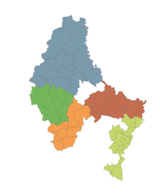
LEADER regions
The layer shows the five LEADER regions of the Grand-Duchy of Luxembourg during the 2023-2029 programming period: Éislek (grey blue), Mëllerdall (red brown), Miselerland (light green), Wëlle Westen (dark green) et Zentrum Westen (orange).
LEADER stands for "Liaison Entre Actions de Développement de l'Economie Rurale" and is a European Union initiative aimed at establishing links between projects and economic players in rural areas. More Information can be accessed on www.leader.lu.
Simple
- Date (Creation)
- 2017-01-10T00:00:00
- Citation identifier
- / a48aec89-7341-459e-a7d3-0e572982b255
- Presentation form
- Digital map
- Status
- On going
- Maintenance and update frequency
- As needed
-
Entités au Grand-Duché de Luxembourg
-
-
Grand-Duché du Luxembourg
-
- Keywords
-
-
LEADER, Areas
-
- Keywords
-
-
geoportail.lu
-
-
geoportail.lu themes
-
-
Agriculture
-
Environment
-
Tourism
-
Main
-
PAG
-
-
geoportail.lu structure
-
-
Agriculture>Administrative units
-
Environment>Administrative units
-
Tourism>Administrative units
-
Main>Geographical location>Administrative units
-
PAG>Geographical location>Administrative units
-
- Access constraints
- Other restrictions
- Spatial representation type
- Vector
- Denominator
- 0
- Language
- Français
- Character set
- UTF8
))
- Reference system identifier
- EPSG / http://www.opengis.net/def/crs/EPSG/0/2169
- OnLine resource
-
Protocol Linkage Name OGC API-Features
https://features.geoportail.lu/collections/746 OGC API - Features
- OnLine resource
-
Protocol Linkage Name OGC:WMS-1.3.0-http-get-map
https://wms.geoportail.lu/public_map_layers/service 746
https://map.geoportail.lu/theme/main?version=3&zoom=8&X=667917&Y=6394482&lang=fr&layers=746&opacities=1 LEADER Areas
Metadata
- File identifier
- a48aec89-7341-459e-a7d3-0e572982b255 XML
- Metadata language
- Français
- Character set
- UTF8
- Hierarchy level
- Dataset
- Hierarchy level name
-
dataset
- Date stamp
- 2023-11-17T08:11:35Z
- Metadata standard name
-
ISO 19115:2003/19139
- Metadata standard version
-
1.0
- Metadata author
-
Organisation name Individual name Electronic mail address Role Ministère de l'Agriculture, de la Viticulture et du Développement rural
Sebastian Hans
- Other language
-
Language Character encoding Luxembourgish; Letzeburgesch UTF8 English UTF8 German UTF8 French UTF8
)))