 geocatalogue.geoportail.lu
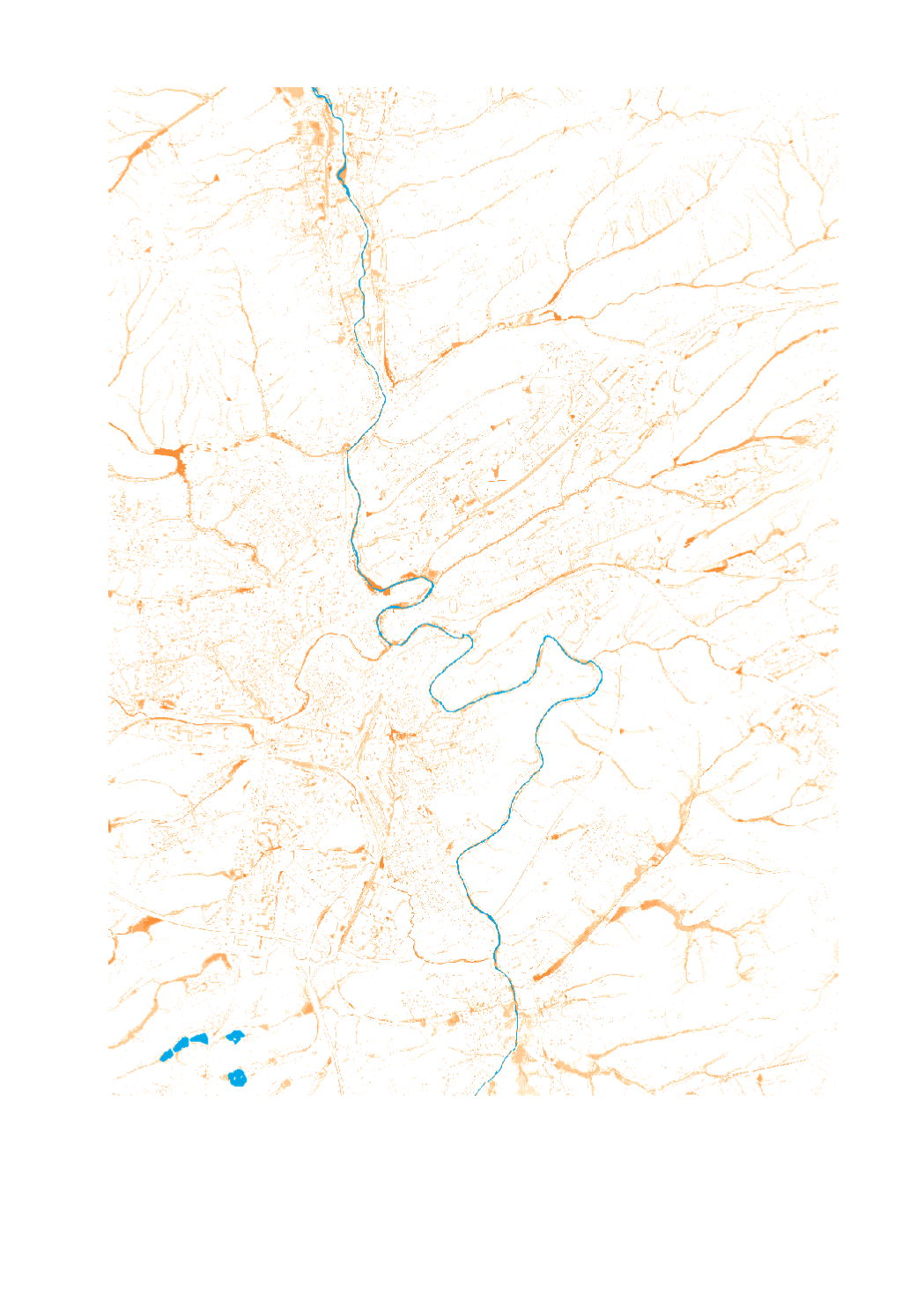
Profondeur d'inondation [D60 T100]
Iwwerschwemmungsdéift [D60 T100]
Flood depth [D60 T100]
Überschwemmungstiefe [D60 T100]
Cette carte montre l'étendue et la profondeur d'inondation des eaux de ruissellement dans un scénario de fortes pluies centennales [D60T100].
Des Kaart wéist d'Iwwerschwemmungsdéift an -Ausdehnung vum Iwwerflächenooffloss an engem honnertjähregen Staarkreenszenario [Dauer 60 min - Jährlechkeet 100].
This map shows the extent and inundation depth of surface runoff in a 100-year heavy rainfall scenario [D60T100].
Diese Karte zeigt die Ausdehung und Überflutungstiefe des Oberflächenabflusses in einem 100-jährigen Starkregenszenario [D60T100].
Simple
-
IdentificateurCitation identifierIdentifikatorIdentificateur
- / 9fd959f0-278c-4ca2-86bd-44c68ddec3cb
-
Forme de la présentationPresentation formPräsentationsformForme de la présentation
-
Carte numériqueDigital mapDigitale KarteCarte numérique
-
EtatStatusBearbeitungsstatusEtat
-
Mise à jour continueOn goingKontinuierliche AktualisierungMise à jour continue
-
Fréquence de mise à jourMaintenance and update frequencyÜberarbeitungsintervallFréquence de mise à jour
-
Lorsque nécessaireAs neededBei BedarfLorsque nécessaire
-
Entités au Grand-Duché de Luxembourg
-
-
Grand-Duché du Luxembourg
Grand-Duché du Luxembourg
Grand-Duché du Luxembourg
Grand-Duché du Luxembourg
-
- Keywords
-
-
Crues subites, Crues soudaines, fortes précipitations
Staarkreen, Starkreen, Starkreenkarten, Staarkreenkarten
Flashflood, Flash Flood, Flashflood maps, heavy rainfall, Flashflood risk map
Starkregen, Starkregenkarten, Starkregenatlas, Oberflächenabflusskarte
-
- Keywords
-
-
geoportail.lu
geoportail.lu
geoportail.lu
geoportail.lu
-
- Keywords
-
-
intranet
intranet
intranet
intranet
-
-
geoportail.lu themes
-
-
Eau
Wasser
Water
Wasser
-
Grand Public
Allgemeng
Main
Allgemein
-
-
geoportail.lu structure
-
-
Eau>Directive inondation [DI]>Crues subites
Eau>Héichwaasserrisikomanagementrichtlinn [HWRM-RL]>Staarkreen
Water>Floods directive [FD]>Flashflood
Wasser>Hochwasserrisikomanagement-Richtlinie [HWRM-RL]>Starkregen
-
Grand Public>Environnement, biologie et géologie>Directive inondation [DI]>Crues subites
Grand Public>Ëmwelt, Biologie a Geologie>Héichwaasserrisikomanagementrichtlinn [HWRM-RL]>Staarkreen
Main>Environment, Biology and Geology>Floods directive [FD]>Flashflood
Allgemein>Umwelt, Biologie und Geologie>Hochwasserrisikomanagement-Richtlinie [HWRM-RL]>Starkregen
-
-
Contraintes d'accèsAccess constraintsZugriffseinschränkungenContraintes d'accès
-
Autres restrictionsOther restrictionsBenutzerdefinierte EinschränkungenAutres restrictions
-
Type de représentation spatialeSpatial representation typeRäumliche DarstellungsartType de représentation spatiale
-
VecteurVectorVektorVecteur
-
Dénominateur de l'échelleDenominatorMaßstabszahlDénominateur de l'échelle
- 0
-
Encodage des caractèresCharacter setZeichensatzEncodage des caractères
-
Utf8UTF8Utf8Utf8
))
-
Nom du système de référenceReference system identifierIdentifikator des ReferenzsystemsNom du système de référence
- EPSG / http://www.opengis.net/def/crs/EPSG/0/2169
- OnLine resource
-
Protocol Linkage Name https://map.geoportail.lu/theme/main?version=3&zoom=8&X=667917&Y=6394482&lang=fr&layers=1710&opacities=1 Profondeur d'inondation [D60 T100]
Iwwerschwemmungséift [D60 T100]
Flood depth [D60 T100]
Überflutungstiefe [D60 T100]
Metadata
-
Identifiant de la ficheFile identifierMetadatensatzidentifikatorIdentifiant de la fiche
- 9fd959f0-278c-4ca2-86bd-44c68ddec3cb XML
-
LangueMetadata languageSpracheLangue
- Français
-
Jeu de caractèresCharacter setZeichensatzJeu de caractères
-
Utf8UTF8Utf8Utf8
-
Type de ressourceHierarchy levelHierarchieebeneType de ressource
-
Jeu de donnéesDatasetDatenbestandJeu de données
- Hierarchy level name
-
dataset
-
Date des métadonnéesDate stampDatumDate des métadonnées
- 2022-07-01T07:02:32
- Metadata standard name
-
ISO 19115:2003/19139
- Metadata standard version
-
1.0
- Metadata author
-
Organisation name Individual name Electronic mail address Role Administration de la gestion de l'eau
Service hydrologie
- Other language
-
Language Character encoding LëtzebuergeschLuxembourgish; LetzeburgeschLuxemburgischLuxembourgeoisUtf8UTF8Utf8Utf8EngleschEnglishEnglischAnglaisUtf8UTF8Utf8Utf8DäitschGermanDeutschAllemandUtf8UTF8Utf8Utf8FranséischFrenchFranzösischFrançaisUtf8UTF8Utf8Utf8
)))