 geocatalogue.geoportail.lu
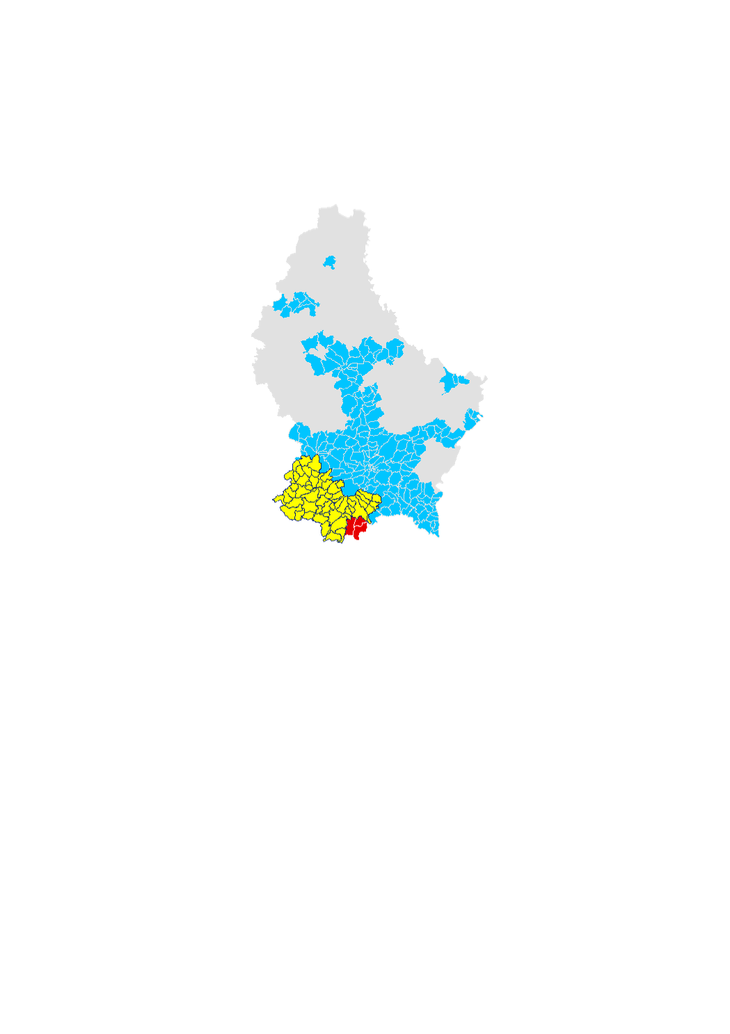
Disponibilité de gaz naturel
Disponibilitéit vun Erdgas
Disponibility of natural gas
Erdgasverfügbarkeit
Cette couche donne une indication concernant la disponibilité de gaz naturel sur une parcelle cadastrale. A petite échelle, les sections cadastrales sont coloriées selon le gestionnaire de réseau actif par commune. Ce sera soit Creos, soit Sudenergie soit la Ville de Dudelange. A grande échelle, les parcelles cadastrales sont coloriées en fonction de la présence d'une conduite de gaz à basse pression dans un rayon de 20m autour de la parcelle. On distingue entre la présence de conduites actives, inactives (conduite disponible, mais pas encore sous pression) et la non présence de conduites. Pour toute information supplémentaire concernant une parcelle, vous pouvez cliquer sur la parcelle afin d'obtenir les coordonnées de contact du gestionnaire de réseau ainsi que d'écrire un email préremplie directement depuis le site.
Dëse Layer gett Iech eng Informatioun iwwert d'Disponibilitéit vun Erdgas op enger bestëmmter Parzell. Am klenge Moossstab gin d'Kadastersektiounen faarweg duergestallt, je nodeem wéieen Netzbedreiwer do aktiv ass. Dëst ass entweder Creos, Sudenergie oder d’Stad Diddeleng. Am grousse Moossstab gin d'Parzelle agefierwt, je nodeem ob eng Gasleitung an engem Rayon vun 20m ronderem d'Parzell läit. Et gëtt en Ënnerscheed gemaach tëschent aktive Leitungen, inaktive Leitungen (Leitung do, mee nach net ënner Drock) a kenge Leitungen. Fir méi Informatiounen fir eng bestëmmte Parzell ze kréien, kënnt dir an d'Kaart klicken, fir d'Koordianten vum Netzbedreiwer gewisen ze kréien an eng vir-ausgefëllt Mail direkt vun do aus kënne fortzeschécken.
This layer gives an indication about the disponibility of natural gas for a given parcel. In a small scale, the cadastral sections are colorized according to the grid operator active in that cadastral section. This can be either Creos, Sudenergie or Dudelange city. In a bigger scale, cadastral parcels are colorized according to the fact that there is a gaz pipe ini a radius of 20m around the parcel. We make a difference between active pipes, inactive pipes (pipes present, but not yet under pressure) and the non presence of pipes. For further information about a given parcel, you can click into the map to get the contact details of the grid operator and send a prefilled email directly from the site.
Dieser Layer dient als Angabe zur Verfügbarkeit von Erdgas auf einer Parzelle. Im kleine Massstab werden die Katastersektionen eingefärbt dargestellt, je nach Netzbetreiber, der in dieser Sektion aktiv ist. Das ist entweder Creos, Sudenergie oder die Stadt Dudelingen. Im grossen Massstab, sind die Katasterparzellen eingefärbt, je nachdem Sie im Umfeld von 20 Metern von einer Gasleitung sind. Es wird unterscheidet zwischen aktiven Leitungen, inaktiven Leitungen (Leitung vorhanden, aber nicht unter Druck), und der Nichtverfügbarkeit von Erdgas. Für genauere Informatiounen zu einer bestimmten Parzelle, können Sie in die Karte klicken, um die Koordinaten des Netzbetreibers zu erhalten und von der Seite aus eine vorausgefüllte Email an den Netzbetreiber zu schicken.
Simple
-
IdentificateurCitation identifierIdentifikatorIdentificateur
- / 9e04e366-fcb7-4836-8d09-41b20f280cb0
-
Forme de la présentationPresentation formPräsentationsformForme de la présentation
-
Carte numériqueDigital mapDigitale KarteCarte numérique
-
EtatStatusBearbeitungsstatusEtat
-
Mise à jour continueOn goingKontinuierliche AktualisierungMise à jour continue
-
Fréquence de mise à jourMaintenance and update frequencyÜberarbeitungsintervallFréquence de mise à jour
-
Lorsque nécessaireAs neededBei BedarfLorsque nécessaire
-
Entités au Grand-Duché de Luxembourg
-
-
Grand-Duché du Luxembourg
Grand-Duché du Luxembourg
Grand-Duché du Luxembourg
Grand-Duché du Luxembourg
-
- Keywords
-
-
énergie, gaz, gaz naturel
Energie, Gas, Erdgas
Energy, Gas, natural gas
Energie, Erdgas, Gas
-
- Keywords
-
-
geoportail.lu
geoportail.lu
geoportail.lu
geoportail.lu
-
-
geoportail.lu themes
-
-
Énergie
Energie
Energy
Energie
-
Grand Public
Allgemeng
Main
Allgemein
-
-
geoportail.lu structure
-
-
Énergie>Disponibilité
Énergie>Disponibilité>Disponibilitéit
Energy>Availability
Energie>Verfügbarkeit
-
Grand Public>Infrastructure et communication>Fourniture d'énergie
Grand Public>Infrastructure et communication>Fourniture d'énergie>Energieversuergung
Main>Infrastructure and communication>Energy supply
Allgemein>Infrastruktur und Kommunikation>Energieversorgung
-
-
Contraintes d'accèsAccess constraintsZugriffseinschränkungenContraintes d'accès
-
Autres restrictionsOther restrictionsBenutzerdefinierte EinschränkungenAutres restrictions
-
Type de représentation spatialeSpatial representation typeRäumliche DarstellungsartType de représentation spatiale
-
VecteurVectorVektorVecteur
-
Dénominateur de l'échelleDenominatorMaßstabszahlDénominateur de l'échelle
- 0
-
Encodage des caractèresCharacter setZeichensatzEncodage des caractères
-
Utf8UTF8Utf8Utf8
))
-
Nom du système de référenceReference system identifierIdentifikator des ReferenzsystemsNom du système de référence
-
EPSG
/
http://www.opengis.net/def/crs/EPSG/0/2169
- OnLine resource
-
Protocol Linkage Name OGC API-Features
https://features.geoportail.lu/collections/1494 OGC API - Features
- OnLine resource
-
Protocol Linkage Name OGC:WMS-1.3.0-http-get-map
https://wms.geoportail.lu/public_map_layers/service 1494
1494
1494
1494
https://map.geoportail.lu/theme/main?version=3&zoom=8&X=667917&Y=6394482&lang=fr&layers=1494&opacities=1 Disponibilité de gaz naturel
Disponibilitéit vun Erdgas
Disponibility of natural gas
Erdgasverfügbarkeit
Metadata
-
Identifiant de la ficheFile identifierMetadatensatzidentifikatorIdentifiant de la fiche
- 9e04e366-fcb7-4836-8d09-41b20f280cb0 XML
-
LangueMetadata languageSpracheLangue
- Français
-
Jeu de caractèresCharacter setZeichensatzJeu de caractères
-
Utf8UTF8Utf8Utf8
-
Type de ressourceHierarchy levelHierarchieebeneType de ressource
-
Jeu de donnéesDatasetDatenbestandJeu de données
- Hierarchy level name
-
dataset
-
Date des métadonnéesDate stampDatumDate des métadonnées
- 2021-07-02T12:09:21Z
- Metadata standard name
-
ISO 19115:2003/19139
- Metadata standard version
-
1.0
- Metadata author
-
Organisation name Individual name Electronic mail address Role Administration du Cadastre et de la Topographie
Service Géoportail
Point de contactPoint of contactAnsprechpartnerPoint de contact
- Other language
-
Language Character encoding LëtzebuergeschLuxembourgish; LetzeburgeschLuxemburgischLuxembourgeoisUtf8UTF8Utf8Utf8EngleschEnglishEnglischAnglaisUtf8UTF8Utf8Utf8DäitschGermanDeutschAllemandUtf8UTF8Utf8Utf8FranséischFrenchFranzösischFrançaisUtf8UTF8Utf8Utf8
)))