 geocatalogue.geoportail.lu
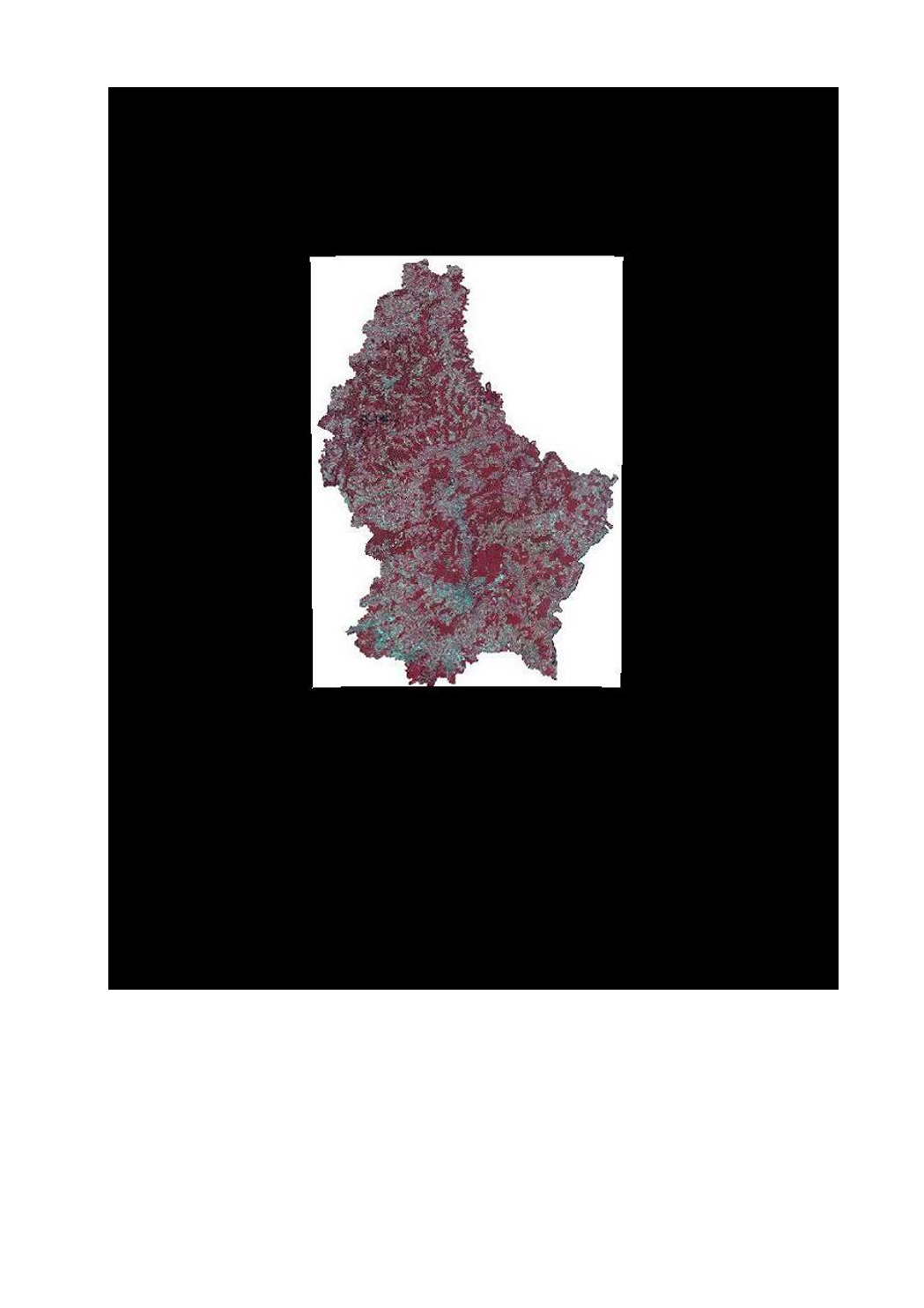
Couche images aériennes et satellitaires - orthophoto 2007 infrarouge
Layer Loft- an Satellitenbiller - Orthophoto 2007 infrarout
Layer air and satellite image - orthophoto 2007 infrared
Layer Luft- und Satellitenbilder - Orthophoto 2007 infrarot
Cette couche contient l'orthophoto de 2007, version infrarouge.
Dese Layer enthält d'Infrarout-Versioun vun der Orthophoto 2007.
This layer contains the infrared version of the orthophoto 2007.
Dieser Layer enthält die Orthophoto von 2007 in der infrarot-Version.
Simple
-
IdentificateurIdentificateurCitation identifierIdentifikator
- / 9848c7ac-0c12-430d-a05f-62dda9e234a0
-
Forme de la présentationForme de la présentationPresentation formPräsentationsform
-
Carte numériqueCarte numériqueDigital mapDigitale Karte
-
EtatEtatStatusBearbeitungsstatus
-
Mise à jour continueMise à jour continueOn goingKontinuierliche Aktualisierung
- Point of contact
-
Organisation name Individual name Electronic mail address Role Administration du Cadastre et de la Topographie
Service du géoportail et de l'ILDG (ACT)
Point de contactPoint de contactPoint of contactAnsprechpartner
Contact pour la ressource
Contact pour la ressource
Point of contact
Kontakt für die Ressource
Contact pour la ressource
Contact pour la ressource
Point of contact
Kontakt für die Ressource
Contact pour la ressource
Contact pour la ressource
Point of contact
Kontakt für die Ressource
Contact pour la ressource
Contact pour la ressource
Point of contact
Kontakt für die Ressource
Contact pour la ressource
Contact pour la ressource
Point of contact
Kontakt für die Ressource
Contact pour la ressource
Contact pour la ressource
Point of contact
Kontakt für die Ressource
Contact pour la ressource
Contact pour la ressource
Point of contact
Kontakt für die Ressource
Contact pour la ressource
Contact pour la ressource
Point of contact
Kontakt für die Ressource
Contact pour la ressource
Contact pour la ressource
Point of contact
Kontakt für die Ressource
Contact pour la ressource
Contact pour la ressource
Point of contact
Kontakt für die Ressource
-
Fréquence de mise à jourFréquence de mise à jourMaintenance and update frequencyÜberarbeitungsintervall
-
Lorsque nécessaireLorsque nécessaireAs neededBei Bedarf
-
Entités au Grand-Duché de Luxembourg
-
-
Grand-Duché du Luxembourg
Grand-Duché du Luxembourg
Grand-Duché du Luxembourg
Grand-Duché du Luxembourg
-
- Keywords
-
- Keywords
-
-
couche
Layer
layer
Layer
-
orthophoto
Orthophoto
orthophoto
Orthophoto
-
infrarouge
Loftbild
image
Bild
-
image
Biller
infrared
Luftbild
-
geoportail.lu
geoportail.lu
geoportail.lu
geoportail.lu
-
-
geoportail.lu themes
-
-
Eau
Wasser
Water
Wasser
-
-
geoportail.lu structure
-
-
Eau>Données de base>Photographies aériennes et spatiales
Eau>Données de base>Photographies aériennes et spatiales>Loft- an Satellitebiller
Water>Geographical location>Aerial and satellite photographs
Wasser>Basisdaten>Luft- und Satellitenbilder
-
-
Contraintes d'utilisationContraintes d'utilisationUse constraintsNutzungseinschränkungen
-
Autres restrictionsAutres restrictionsOther restrictionsBenutzerdefinierte Einschränkungen
- Other constraints
-
Creative Commons 1.0 Universal (CC0 1.0) Public Domain Dedication
-
Type de représentation spatialeType de représentation spatialeSpatial representation typeRäumliche Darstellungsart
-
VecteurVecteurVectorVektor
-
Dénominateur de l'échelleDénominateur de l'échelleDenominatorMaßstabszahl
- 0
-
Langue de la ressourceLangue de la ressourceLanguageSprache
- Français
-
Langue de la ressourceLangue de la ressourceLanguageSprache
- English
-
Langue de la ressourceLangue de la ressourceLanguageSprache
- Lëtzebuergesch
-
Langue de la ressourceLangue de la ressourceLanguageSprache
- Deutsch
-
Encodage des caractèresEncodage des caractèresCharacter setZeichensatz
-
Utf8Utf8UTF8Utf8
-
Catégorie ISOCatégorie ISOTopic categoryISO-Thematik
-
-
Sciences de la terre, géosciencesSciences de la terre, géosciencesGeoscientific informationGeowissenschaften
-
))
-
Nom du système de référenceNom du système de référenceReference system identifierIdentifikator des Referenzsystems
- EPSG / http://www.opengis.net/def/crs/EPSG/0/2169
- OnLine resource
-
Protocol Linkage Name OGC:WMS-1.3.0-http-get-map
https://wms.geoportail.lu/public_map_layers/service 311
311
311
311
OGC:WMS-1.3.0-http-get-map
http://wmts1.geoportail.lu/opendata/service?request=getCapabilities&service=WMS&version=1.3.0 ortho_irc
WWW:LINK-1.0-http--link
https://data.public.lu/fr/datasets/orthophoto-officelle-du-grand-duche-de-luxembourg-edition-2007/
- OnLine resource
-
Protocol Linkage Name https://map.geoportail.lu/theme/main?version=3&zoom=8&X=667917&Y=6394482&lang=fr&layers=311&opacities=1 Orthophoto 2010 (infrarouge)
Orthophoto 2010 (infrarout)
Orthophoto 2010 (infrared)
Orthophoto 2010 (infrarot)
Metadata
-
Identifiant de la ficheIdentifiant de la ficheFile identifierMetadatensatzidentifikator
- 9848c7ac-0c12-430d-a05f-62dda9e234a0 XML
-
LangueLangueMetadata languageSprache
- Français
-
Jeu de caractèresJeu de caractèresCharacter setZeichensatz
-
Utf8Utf8UTF8Utf8
-
Type de ressourceType de ressourceHierarchy levelHierarchieebene
-
Jeu de donnéesJeu de donnéesDatasetDatenbestand
- Hierarchy level name
-
dataset
-
Date des métadonnéesDate des métadonnéesDate stampDatum
- 2021-02-04T22:13:56
- Metadata standard name
-
ISO 19115:2003/19139
- Metadata standard version
-
1.0
- Metadata author
-
Organisation name Individual name Electronic mail address Role Administration du Cadastre et de la Topographie
Service du géoportail et de l'ILDG (ACT)
Point de contactPoint de contactPoint of contactAnsprechpartner
- Other language
-
Language Character encoding FrançaisFranséischFrenchFranzösischUtf8Utf8UTF8Utf8LuxembourgeoisLëtzebuergeschLuxembourgish; LetzeburgeschLuxemburgischUtf8Utf8UTF8Utf8AnglaisEngleschEnglishEnglischUtf8Utf8UTF8Utf8AllemandDäitschGermanDeutschUtf8Utf8UTF8Utf8
)))