 geocatalogue.geoportail.lu
Orthophoto 2019
Orthophoto 2019
Orthophoto 2019
Orthophoto 2019
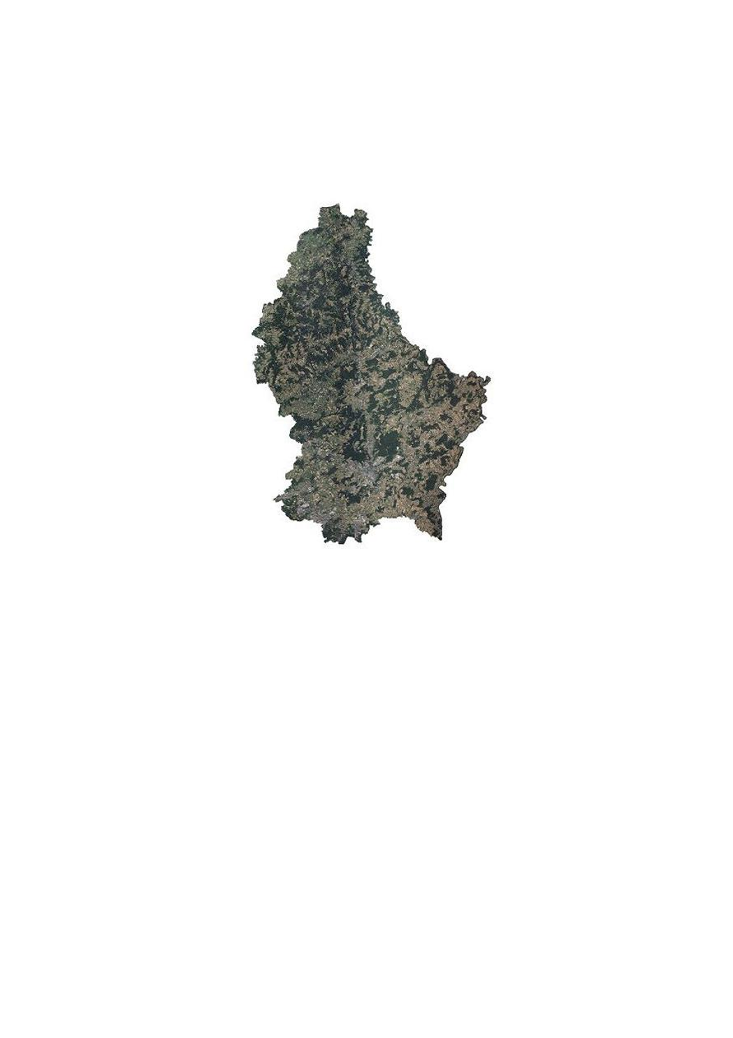
Cette couche contient les orthophotos officielles couvrant le territoire national. 3 vols ont été réalisés les 4 et 5 juillet et le 22 août 2019, avec une élévation solaire de > 35°. La résolution au sol native est < 0,20 m GSD (Ground Sampling Distance). Le déversement sur image, général est inférieur ou égal à 25 %, alors que le déversement sur la Ville de Luxembourg est inférieur ou égal à 15 %, pour une zone de 10 x 9 km soit 90 km2, centrée sur les coordonnées Est 78000 et Nord 74500. La couverture du Grand-Duché du Luxembourg est assurée avec un débord de minimum 50 m au-delà de la limite d'Etat.
Dëse Layer enthält déi offiziell Orthophoto vum Territoire vu Lëtzebuerg. 3 Iwwerfléiungen sinn den 4. an 5. Juli an den 22. August 2019, bei engem Sonnestand vun > 35° duerchgefouert ginn. D'Opléisung vun den Pixelen um Buedem läit bei < 0,20 m GSD (Ground Sampling Distance). Den Bildsturz läit beim ganzen Land bei < 25 %, mat Ausnam vun der Stad Lëtzebuerg, wou en op engem Gebitt vun 10 x 9 km (90 km2, zentréiert op den Koordinaten 78000 Ost an 74500 Nord) bei < 15 % läit. Op den Grenzen gouf en Gebitt vun 50 m iwwert d'Landesgrenzen eraus mat erfaasst.
This layer contains the official orthophotos covering the national territory of Luxembourg. The 3 surveying flights took place on 4 and 5 July and 22 August 2019, with a sun position of > 35°. The ground sampling distance is < 0,20 m. The perspective displacement is in general < 25 %, except for Luxembourg-City, where it is < 15 % for a zone of 10 x 9 km (90 km2, centered on the coordinates 78000 east and 74500 north). On the borders, a zone of 50m behind the country border is included.
Dieser Layer enthält die amtlichen Orthophotos vom gesamten Gebiet des Großherzogtums Luxemburg. 3 Überfliegungen wurden am 4. und 5. Juli und 22. August 2019, bei einem Sonnenstand von > 35° durchgeführt. Die Bodenauflösung liegt bei < 0,2 0m GSD (Ground Sampling Distance). Der Bildsturz liegt für das ganze Land bei < 25 %, mit Ausnahme von Luxemburg-Stadt, wo er auf einem Gebiet von 10 x 9 km (90 km2, zentriert auf den Koordinaten 78000 Ost und 74500 Nord) bei < 15 % liegt. An den Grenzen wird ein Gebiet bis 50 m über die Landesgrenzen hinaus mit abgedeckt.
Simple
-
IdentificateurCitation identifierIdentifikatorIdentificateur
- / 97c88ef6-6c64-4cb0-a134-06bb42b2b448
-
Forme de la présentationPresentation formPräsentationsformForme de la présentation
-
Carte numériqueDigital mapDigitale KarteCarte numérique
-
EtatStatusBearbeitungsstatusEtat
-
Mise à jour continueOn goingKontinuierliche AktualisierungMise à jour continue
-
Fréquence de mise à jourMaintenance and update frequencyÜberarbeitungsintervallFréquence de mise à jour
-
Lorsque nécessaireAs neededBei BedarfLorsque nécessaire
-
Entités au Grand-Duché de Luxembourg
-
-
Grand-Duché du Luxembourg
Grand-Duché du Luxembourg
Grand-Duché du Luxembourg
Grand-Duché du Luxembourg
-
- Keywords
-
-
orthophoto, image, aàrienne, géodonnée, 2019
Orthophoto, Loftbild, Loftopnam, Geodaten, 2019
orthophoto, aerial, photograph, geodata, 2019
Orthophoto, Luftbild, Luftaufnahme, Geodaten, 2019
-
- Keywords
-
-
geoportail.lu
geoportail.lu
geoportail.lu
geoportail.lu
-
-
geoportail.lu themes
-
-
Grand Public
Allgemeng
Main
Allgemein
-
Eau
Wasser
Water
Wasser
-
-
geoportail.lu structure
-
-
Grand Public>Couverture du sol>Images aériennes et satellites
Grand Public>Couverture du sol>Images aériennes et satellites>Loft- a Satellitebiller
Main>Land surface>Orthophoto-images
Allgemein>Oberflächendarstellung>Luft und Satellitenbilder
-
Eau>Données de base>Photographies aériennes et spatiales
Eau>Données de base>Photographies aériennes et spatiales>Loft- an Satellitebiller
Water>Geographical location>Aerial and satellite photographs
Wasser>Basisdaten>Luft- und Satellitenbilder
-
-
Contraintes d'accèsAccess constraintsZugriffseinschränkungenContraintes d'accès
-
Autres restrictionsOther restrictionsBenutzerdefinierte EinschränkungenAutres restrictions
-
Contraintes d'utilisationUse constraintsNutzungseinschränkungenContraintes d'utilisation
-
Autres restrictionsOther restrictionsBenutzerdefinierte EinschränkungenAutres restrictions
- Other constraints
-
Creative Commons 1.0 Universal (CC0 1.0) Public Domain Dedication
-
Type de représentation spatialeSpatial representation typeRäumliche DarstellungsartType de représentation spatiale
-
VecteurVectorVektorVecteur
-
Dénominateur de l'échelleDenominatorMaßstabszahlDénominateur de l'échelle
- 0
-
Encodage des caractèresCharacter setZeichensatzEncodage des caractères
-
Utf8UTF8Utf8Utf8
))
-
Nom du système de référenceReference system identifierIdentifikator des ReferenzsystemsNom du système de référence
- EPSG / http://www.opengis.net/def/crs/EPSG/0/2169
- OnLine resource
-
Protocol Linkage Name OGC:WMS-1.3.0-http-get-map
https://wms.geoportail.lu/public_map_layers/service 1784
1784
1784
1784
OGC:WMS-1.3.0-http-get-map
http://wmts1.geoportail.lu/opendata/service?request=getCapabilities&service=WMS&version=1.3.0 ortho_2019
WWW:LINK-1.0-http--link
https://data.public.lu/fr/datasets/orthophoto-officielle-du-grand-duche-de-luxembourg-edition-2019/ Orthophoto 2019
Orthophoto 2019
Orthophoto 2019
Orthophoto 2019
- OnLine resource
-
Protocol Linkage Name https://map.geoportail.lu/theme/main?version=3&zoom=8&X=667917&Y=6394482&lang=fr&layers=1784&opacities=1 Orthophoto 2019
Orthophoto 2019
Orthophoto 2019
Orthophoto 2019
Metadata
-
Identifiant de la ficheFile identifierMetadatensatzidentifikatorIdentifiant de la fiche
- 97c88ef6-6c64-4cb0-a134-06bb42b2b448 XML
-
LangueMetadata languageSpracheLangue
- Français
-
Jeu de caractèresCharacter setZeichensatzJeu de caractères
-
Utf8UTF8Utf8Utf8
-
Type de ressourceHierarchy levelHierarchieebeneType de ressource
-
Jeu de donnéesDatasetDatenbestandJeu de données
- Hierarchy level name
-
dataset
-
Date des métadonnéesDate stampDatumDate des métadonnées
- 2023-05-23T09:32:05
- Metadata standard name
-
ISO 19115:2003/19139
- Metadata standard version
-
1.0
- Metadata author
-
Organisation name Individual name Electronic mail address Role Administration du Cadastre et de la Topographie
Administration du Cadastre et de la Topographie
Point de contactPoint of contactAnsprechpartnerPoint de contact
- Other language
-
Language Character encoding LëtzebuergeschLuxembourgish; LetzeburgeschLuxemburgischLuxembourgeoisUtf8UTF8Utf8Utf8EngleschEnglishEnglischAnglaisUtf8UTF8Utf8Utf8DäitschGermanDeutschAllemandUtf8UTF8Utf8Utf8FranséischFrenchFranzösischFrançaisUtf8UTF8Utf8Utf8
)))