 geocatalogue.geoportail.lu
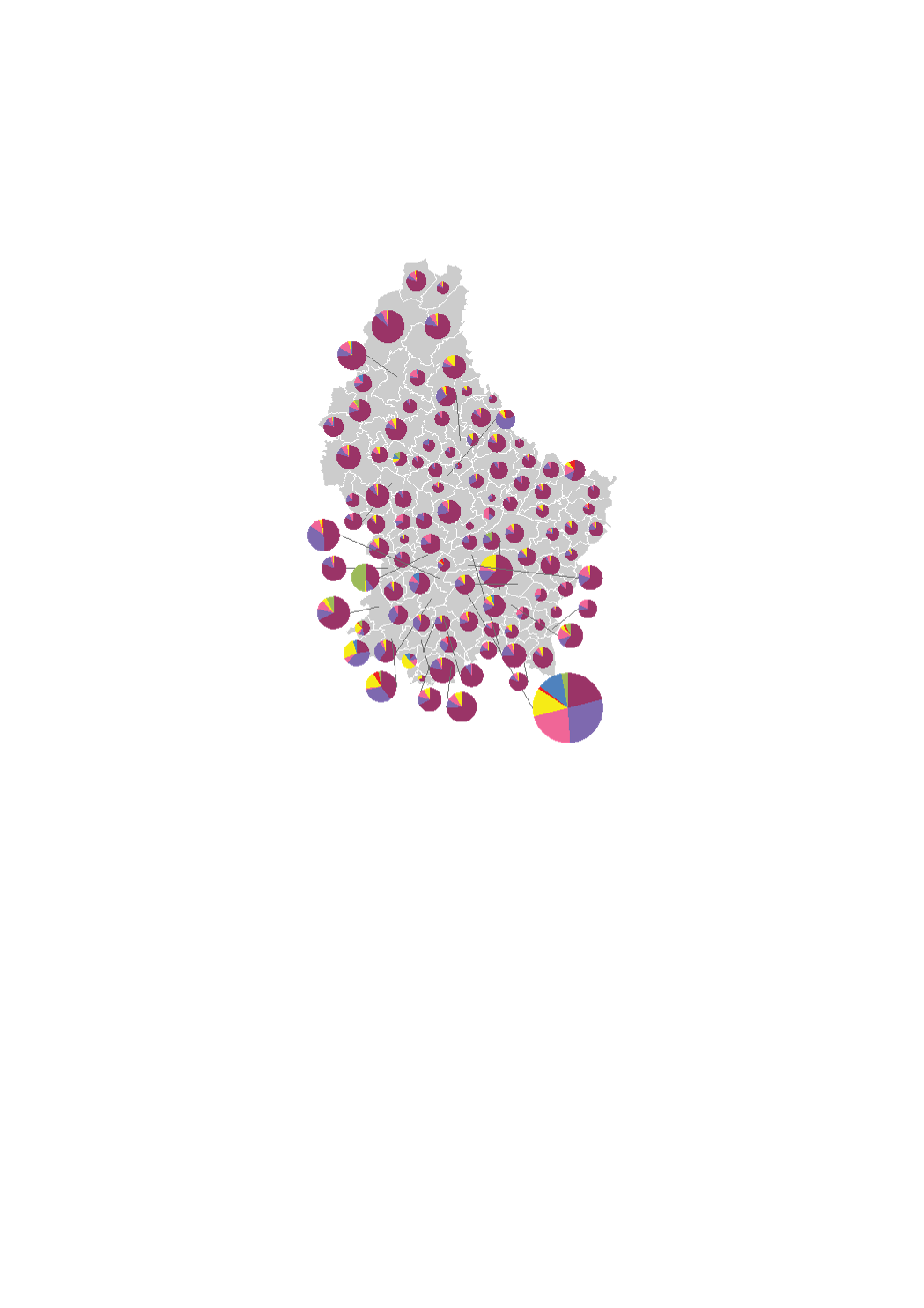
Available land area by type of owner (2016)
The land available for housing by type of owner corresponds to all the vacant land within the residential areas and to 75% of vacant land within the mixed-used areas in the municipalities' general land use plans (PAG) (in hectares). The type of owners are on the one hand private owners (individuals, legal entities, co-ownerships) and on the other hand public actors (municipalities, State, Funds, SNHBM). This is a theoretical potential, independently of the will of the owners to develop the land. The data sources are the digitalized cadastral parcels, the orthophoto-images and the type of owner from the "Administration du Cadastre et de la Topographie", as well as the PAG and PAP of the municipalities digitalized in collaboration with the Ministry of Interior.
Simple
- Citation identifier
- / 8c6408ca-4195-4cf0-b4bc-8c095f372c42
- Presentation form
- Digital map
- Status
- On going
- Point of contact
-
Organisation name Individual name Electronic mail address Role LISER
Observatoire de l'Habitat du Ministère du Logement
Point of contact
- Maintenance and update frequency
- As needed
-
Entités au Grand-Duché de Luxembourg
-
-
Grand-Duché du Luxembourg
-
- Keywords
-
- Keywords
-
-
available land area
-
residential land
-
type of owner
-
type de propriétaire
-
geoportail.lu
-
-
geoportail.lu themes
-
-
Housing
-
-
geoportail.lu structure
-
-
Housing>Land available for housing
-
- Use constraints
- Other restrictions
- Other constraints
-
Creative Commons 1.0 Universal (CC0 1.0) Public Domain Dedication
- Spatial representation type
- Vector
- Denominator
- 0
- Character set
- UTF8
))
- Reference system identifier
- EPSG / http://www.opengis.net/def/crs/EPSG/0/2169
- OnLine resource
-
Protocol Linkage Name OGC:WMS-1.3.0-http-get-map
https://wms.geoportail.lu/public_map_layers/service 1745
WWW:LINK-1.0-http--link
https://data.public.lu/fr/datasets/superficie-des-terrains-disponibles-pour-lhabitat-en-2016-par-type-de-proprietaires/
- OnLine resource
-
Protocol Linkage Name https://map.geoportail.lu/theme/main?version=3&zoom=8&X=667917&Y=6394482&lang=fr&layers=1745&opacities=1 Available land area by type of owner (2016)
Metadata
- File identifier
- 8c6408ca-4195-4cf0-b4bc-8c095f372c42 XML
- Metadata language
- Français
- Character set
- UTF8
- Hierarchy level
- Dataset
- Hierarchy level name
-
dataset
- Date stamp
- 2021-02-04T22:25:17
- Metadata standard name
-
ISO 19115:2003/19139
- Metadata standard version
-
1.0
- Metadata author
-
Organisation name Individual name Electronic mail address Role LISER
Observatoire de l'Habitat du Ministère du Logement
Point of contact
- Other language
-
Language Character encoding French UTF8 Luxembourgish; Letzeburgesch UTF8 English UTF8 German UTF8
)))