 geocatalogue.geoportail.lu
Communes cadastrales
Kadastergemengen
Cadastral municipalities
Katastergemeinden
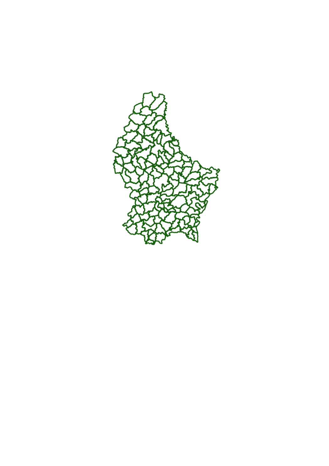
Cette couche représente les limites des 130 communes telles qu'elles existaient au début du 19e siècle lors de l'établissement du cadastre à Luxembourg.
Dëse Layer weist d'Grenzen vun den 130 Gemengen sou wéi se um Ufank vum 19. Jorhonnert existéiert hunn wéi de Kadaster zu Lëtzebuerg gemaach ginn ass.
This layer shows the borders of the 130 municipalities as they existed in the beginning of the 19th century, when the cadastre was created in Luxemburg.
Dieser Layer zeigt die Grenzen der 130 Gemeinden wie sie anfangs des 19. Jahrhunderts während der ersten Erstellung des Katasters in Luxemburg existierten.
Simple
-
Date (Création)Date (Creation)Datumsangaben (Erstellung)Date (Création)
- 1829-01-01T00:00:00
-
Date (Révision)Date (Revision)Datumsangaben (Überarbeitung)Date (Révision)
- 1829-01-01T00:00:00
-
IdentificateurCitation identifierIdentifikatorIdentificateur
- / 8a95f8b2-2cfb-42e7-a51c-02084228b364
-
Forme de la présentationPresentation formPräsentationsformForme de la présentation
-
Carte numériqueDigital mapDigitale KarteCarte numérique
-
EtatStatusBearbeitungsstatusEtat
-
Mise à jour continueOn goingKontinuierliche AktualisierungMise à jour continue
- Point of contact
-
Organisation name Individual name Electronic mail address Role Administration du Cadastre et de la Topographie
Service du géoportail et de l'ILDG (ACT)
Point de contactPoint of contactAnsprechpartnerPoint de contact
-
Fréquence de mise à jourMaintenance and update frequencyÜberarbeitungsintervallFréquence de mise à jour
-
Lorsque nécessaireAs neededBei BedarfLorsque nécessaire
-
Entités au Grand-Duché de Luxembourg
-
-
Grand-Duché du Luxembourg
Grand-Duché du Luxembourg
Grand-Duché du Luxembourg
Grand-Duché du Luxembourg
-
- Keywords
-
- Keywords
-
-
limites administratives
administrativ Grenzen
administrative boundaries
Verwaltungsgrenzen
-
administration
Ënnerandelung
boundary
Verwaltung
-
subdivision
Gebitt
administration
Unterteilung
-
territoire national
Territoire
subdivision
Hoheitsgebiet
-
canton
Kanton
territory
Kanton
-
commune
Gemeng
canton
Gemeinde
-
geoportail.lu
geoportail.lu
geoportail.lu
geoportail.lu
-
-
geoportail.lu themes
-
-
Urban Farming
Urban Farming
Urban Farming
Urban Farming
-
Grand Public
Allgemeng
Main
Allgemein
-
-
geoportail.lu structure
-
-
Urban Farming>Parcelles cadastrales
Urban Farming>Parcelles cadastrales>Kadasterparzellen
Urban Farming>Cadastral data
Urban Farming>Katasterparzellen
-
Grand Public>Données de base>Parcelles cadastrales
Grand Public>Données de base>Parcelles cadastrales>Kadasterparzellen
Main>Geographical location>Cadastral data
Allgemein>Basisdaten>Katasterparzellen
-
-
Contraintes d'utilisationUse constraintsNutzungseinschränkungenContraintes d'utilisation
-
Autres restrictionsOther restrictionsBenutzerdefinierte EinschränkungenAutres restrictions
-
Autres contraintes
-
Attribution 4.0 International (CC BY 4.0)
-
Type de représentation spatialeSpatial representation typeRäumliche DarstellungsartType de représentation spatiale
-
VecteurVectorVektorVecteur
-
Dénominateur de l'échelleDenominatorMaßstabszahlDénominateur de l'échelle
- 2500
-
Langue de la ressourceLanguageSpracheLangue de la ressource
- Lëtzebuergesch
-
Langue de la ressourceLanguageSpracheLangue de la ressource
- Deutsch
-
Langue de la ressourceLanguageSpracheLangue de la ressource
- Français
-
Langue de la ressourceLanguageSpracheLangue de la ressource
- English
-
Encodage des caractèresCharacter setZeichensatzEncodage des caractères
-
Utf8UTF8Utf8Utf8
-
Catégorie ISOTopic categoryISO-ThematikCatégorie ISO
-
-
Constructions et ouvragesStructureBauwerkeConstructions et ouvrages
-
))
-
Nom du système de référenceReference system identifierIdentifikator des ReferenzsystemsNom du système de référence
-
EPSG
/
http://www.opengis.net/def/crs/EPSG/0/2169
- Distribution format
-
Name Version DWG
SHAPE
DXF
- OnLine resource
-
Protocol Linkage Name OGC:WMS-1.3.0-http-get-map
https://wms.geoportail.lu/public_map_layers/service 153
153
153
153
OGC:WMS-1.3.0-http-get-map
http://wmts1.geoportail.lu/opendata/service?request=getCapabilities&service=WMS&version=1.3.0 communes_cadastrales
WWW:LINK-1.0-http--link
https://data.public.lu/fr/datasets/plan-cadastral-numerise-pcn/ OGC API-Features
https://features.geoportail.lu/collections/153 OGC API - Features
- OnLine resource
-
Protocol Linkage Name https://map.geoportail.lu/theme/main?version=3&zoom=8&X=667917&Y=6394482&lang=fr&layers=153&opacities=1 Communes cadastrales
Kadastergemengen
Cadastral municipalities
Katastergemeinden
-
Généralités sur la provenanceGénéralités sur la provenanceStatementErläuterung
-
Données du plan cadastral d'origine sur support papier, scannées et digitalisées.
Daten vum Urkadasterplang op Pabeier, gescannt an digitaliséiert.
Data of the original cadastre on paper media, scanned and digitized.
Daten des Urkatasters auf Papier, gescannt und digitalisiert.
Metadata
-
Identifiant de la ficheFile identifierMetadatensatzidentifikatorIdentifiant de la fiche
- 8a95f8b2-2cfb-42e7-a51c-02084228b364 XML
-
LangueMetadata languageSpracheLangue
- Français
-
Jeu de caractèresCharacter setZeichensatzJeu de caractères
-
Utf8UTF8Utf8Utf8
-
Type de ressourceHierarchy levelHierarchieebeneType de ressource
-
Jeu de donnéesDatasetDatenbestandJeu de données
- Hierarchy level name
-
dataset
-
Date des métadonnéesDate stampDatumDate des métadonnées
- 2021-02-04T23:29:21Z
- Metadata standard name
-
ISO 19115:2003/19139
- Metadata standard version
-
1.0
- Metadata author
-
Organisation name Individual name Electronic mail address Role Administration du Cadastre et de la Topographie
Service du géoportail et de l'ILDG (ACT)
Point de contactPoint of contactAnsprechpartnerPoint de contact
- Other language
-
Language Character encoding LëtzebuergeschLuxembourgish; LetzeburgeschLuxemburgischLuxembourgeoisUtf8UTF8Utf8Utf8EngleschEnglishEnglischAnglaisUtf8UTF8Utf8Utf8DäitschGermanDeutschAllemandUtf8UTF8Utf8Utf8FranséischFrenchFranzösischFrançaisUtf8UTF8Utf8Utf8
)))