 geocatalogue.geoportail.lu
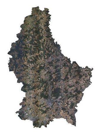
Orthophoto 2020
This layer contains the official orthophotos covering the national territory of Luxembourg. The surveying flights took place on July 30 and 31, August 5, 6, and 7 and September 13, 14, 15 and 19, 2020, with a sun position of > 35°. The ground sampling distance is < 0,20 m. The perspective displacement is < 25 %. On the borders, a zone of 50 m behind the country border is included.
Simple
- Citation identifier
- / 87870b8a-10a1-4c33-bf50-7efe851fd450
- Presentation form
- Digital map
- Status
- On going
- Maintenance and update frequency
- As needed
-
Entités au Grand-Duché de Luxembourg
-
-
Grand-Duché du Luxembourg
-
- Keywords
-
-
orthophoto, aerial, photograph, geodata, 2020
-
- Keywords
-
-
geoportail.lu
-
-
geoportail.lu themes
-
-
Main
-
-
geoportail.lu structure
-
-
Main>Land surface>Orthophoto-images
-
- Use constraints
- Other restrictions
- Other constraints
-
Creative Commons 1.0 Universal (CC0 1.0) Public Domain Dedication
- Access constraints
- Other restrictions
- Spatial representation type
- Vector
- Denominator
- 0
- Character set
- UTF8
))
- Reference system identifier
- EPSG / http://www.opengis.net/def/crs/EPSG/0/2169
- OnLine resource
-
Protocol Linkage Name OGC:WMS-1.3.0-http-get-map
https://wms.geoportail.lu/public_map_layers/service 2056
OGC:WMS-1.3.0-http-get-map
http://wmts1.geoportail.lu/opendata/service?request=getCapabilities&service=WMS&version=1.3.0 ortho_2020
UKST
https://map.geoportail.lu/theme/main?version=3&zoom=10&X=696686&Y=6410125&lang=fr&rotation=0&layers=2056&opacities=1&bgLayer=basemap_2015_global&crosshair=false Orthophoto 2020
WWW:LINK-1.0-http--link
https://data.public.lu/fr/datasets/orthophoto-officielle-du-grand-duche-de-luxembourg-edition-2020/ Orthophoto 2020
Metadata
- File identifier
- 87870b8a-10a1-4c33-bf50-7efe851fd450 XML
- Metadata language
- Français
- Character set
- UTF8
- Hierarchy level
- Dataset
- Hierarchy level name
-
dataset
- Date stamp
- 2022-07-27T09:53:36
- Metadata standard name
-
ISO 19115:2003/19139
- Metadata standard version
-
1.0
- Metadata author
-
Organisation name Individual name Electronic mail address Role Administration du Cadastre et de la Topographie
Administration du Cadastre et de la Topographie
Point of contact
- Other language
-
Language Character encoding Luxembourgish; Letzeburgesch UTF8 English UTF8 German UTF8 French UTF8
)))