 geocatalogue.geoportail.lu
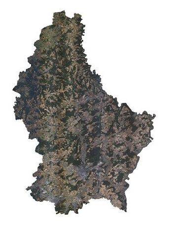
Orthophoto 2020
Orthophoto 2020
Orthophoto 2020
Orthophoto 2020
Cette couche contient les orthophotos officielles couvrant le territoire national. Les vols ont été réalisés le 30 et 31 juillet, le 5, 6 et 7 août et le 13, 14, 15 et 19 septembre 2020, avec une élévation solaire de > 35°. La résolution au sol native est < 0,10m GSD (Ground Sampling Distance). La précision planimétrique absolue de l’orthophoto peut être indiquée avec un écart moyen quadratique EMQ <= 20cm. Le déversement est inférieur ou égal à 25 %. La couverture du Grand-Duché du Luxembourg est assurée avec un débord de minimum 50 m au-delà de la limite d'Etat.
Dëse Layer enthält déi offiziell Orthophoto vum Territoire vu Lëtzebuerg. D'Iwwerfléiungen sinn den 30. an 31. Juli, den 5., 6., an 7. August an 13., 14., 15., an 19. September, bei engem Sonnestand vun > 35° duerchgefouert ginn. D'Opléisung vun den Pixelen um Buedem läit bei < 0,10 m GSD (Ground Sampling Distance). Den Bildsturz läit bei < 25 %. Op den Grenzen gouf en Gebitt vun 50 m iwwert d'Landesgrenzen eraus mat erfaasst.
This layer contains the official orthophotos covering the national territory of Luxembourg. The surveying flights took place on July 30 and 31, August 5, 6, and 7 and September 13, 14, 15 and 19, 2020, with a sun position of > 35°. The ground sampling distance is < 0,20 m. The perspective displacement is < 25 %. On the borders, a zone of 50 m behind the country border is included.
Dieser Layer enthält die amtlichen Orthophotos vom gesamten Gebiet des Großherzogtums Luxemburg. Die Überfliegungen wurden am 30. und 31. Juli, 5., 6., und 7. August und 13., 14., 15., und 19. September 2020, bei einem Sonnenstand von > 35° durchgeführt. Die Bodenauflösung liegt bei < 0,10 m GSD (Ground Sampling Distance). Der Bildsturz liegt bei < 25 %. An den Grenzen wird ein Gebiet bis 50 m über die Landesgrenzen hinaus mit abgedeckt.
Simple
-
IdentificateurCitation identifierIdentifikatorIdentificateur
- / 87870b8a-10a1-4c33-bf50-7efe851fd450
-
Forme de la présentationPresentation formPräsentationsformForme de la présentation
-
Carte numériqueDigital mapDigitale KarteCarte numérique
-
EtatStatusBearbeitungsstatusEtat
-
Mise à jour continueOn goingKontinuierliche AktualisierungMise à jour continue
-
Fréquence de mise à jourMaintenance and update frequencyÜberarbeitungsintervallFréquence de mise à jour
-
Lorsque nécessaireAs neededBei BedarfLorsque nécessaire
-
Entités au Grand-Duché de Luxembourg
-
-
Grand-Duché du Luxembourg
Grand-Duché du Luxembourg
Grand-Duché du Luxembourg
Grand-Duché du Luxembourg
-
- Keywords
-
-
orthophoto, image, aérienne, géodonnée, 2020
Orthophoto, Loftbild, Loftopnam, Geodaten, 2020
orthophoto, aerial, photograph, geodata, 2020
Orthophoto, Luftbild, Luftaufnahme, Geodaten, 2020
-
- Keywords
-
-
geoportail.lu
geoportail.lu
geoportail.lu
geoportail.lu
-
-
geoportail.lu themes
-
-
Grand Public
Allgemeng
Main
Allgemein
-
-
geoportail.lu structure
-
-
Grand Public>Couverture du sol>Images aériennes et satellites
Grand Public>Couverture du sol>Images aériennes et satellites>Loft- a Satellitebiller
Main>Land surface>Orthophoto-images
Allgemein>Oberflächendarstellung>Luft und Satellitenbilder
-
-
Contraintes d'utilisationUse constraintsNutzungseinschränkungenContraintes d'utilisation
-
Autres restrictionsOther restrictionsBenutzerdefinierte EinschränkungenAutres restrictions
- Other constraints
-
Creative Commons 1.0 Universal (CC0 1.0) Public Domain Dedication
-
Contraintes d'accèsAccess constraintsZugriffseinschränkungenContraintes d'accès
-
Autres restrictionsOther restrictionsBenutzerdefinierte EinschränkungenAutres restrictions
-
Type de représentation spatialeSpatial representation typeRäumliche DarstellungsartType de représentation spatiale
-
VecteurVectorVektorVecteur
-
Dénominateur de l'échelleDenominatorMaßstabszahlDénominateur de l'échelle
- 0
-
Encodage des caractèresCharacter setZeichensatzEncodage des caractères
-
Utf8UTF8Utf8Utf8
))
-
Nom du système de référenceReference system identifierIdentifikator des ReferenzsystemsNom du système de référence
- EPSG / http://www.opengis.net/def/crs/EPSG/0/2169
- OnLine resource
-
Protocol Linkage Name OGC:WMS-1.3.0-http-get-map
https://wms.geoportail.lu/public_map_layers/service 2056
2056
2056
2056
OGC:WMS-1.3.0-http-get-map
http://wmts1.geoportail.lu/opendata/service?request=getCapabilities&service=WMS&version=1.3.0 ortho_2020
ortho_2020
ortho_2020
ortho_2020
UKST
https://map.geoportail.lu/theme/main?version=3&zoom=10&X=696686&Y=6410125&lang=fr&rotation=0&layers=2056&opacities=1&bgLayer=basemap_2015_global&crosshair=false Orthophoto 2020
Orthophoto 2020
Orthophoto 2020
Orthophoto 2020
WWW:LINK-1.0-http--link
https://data.public.lu/fr/datasets/orthophoto-officielle-du-grand-duche-de-luxembourg-edition-2020/ Orthophoto 2020
Orthophoto 2020
Orthophoto 2020
Orthophoto 2020
Metadata
-
Identifiant de la ficheFile identifierMetadatensatzidentifikatorIdentifiant de la fiche
- 87870b8a-10a1-4c33-bf50-7efe851fd450 XML
-
LangueMetadata languageSpracheLangue
- Français
-
Jeu de caractèresCharacter setZeichensatzJeu de caractères
-
Utf8UTF8Utf8Utf8
-
Type de ressourceHierarchy levelHierarchieebeneType de ressource
-
Jeu de donnéesDatasetDatenbestandJeu de données
- Hierarchy level name
-
dataset
-
Date des métadonnéesDate stampDatumDate des métadonnées
- 2022-07-27T09:53:36
- Metadata standard name
-
ISO 19115:2003/19139
- Metadata standard version
-
1.0
- Metadata author
-
Organisation name Individual name Electronic mail address Role Administration du Cadastre et de la Topographie
Administration du Cadastre et de la Topographie
Point de contactPoint of contactAnsprechpartnerPoint de contact
- Other language
-
Language Character encoding LëtzebuergeschLuxembourgish; LetzeburgeschLuxemburgischLuxembourgeoisUtf8UTF8Utf8Utf8EngleschEnglishEnglischAnglaisUtf8UTF8Utf8Utf8DäitschGermanDeutschAllemandUtf8UTF8Utf8Utf8FranséischFrenchFranzösischFrançaisUtf8UTF8Utf8Utf8
)))