 geocatalogue.geoportail.lu
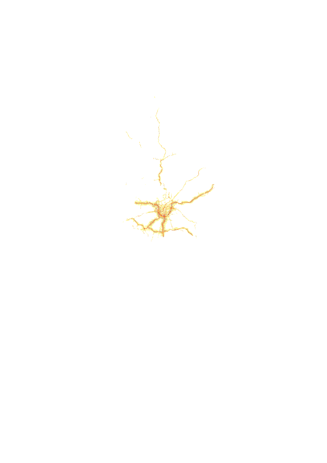
Routes principales 2016 (Lngt)
Haaptverkéiersstroossen 2016 (Lngt)
Major Roads 2016 (Lngt)
Hauptverkehrsstraßen 2016 (Lngt)
Carte de bruit de toutes les routes principales de plus de 3 millions de véhicules par an situées sur le territoire du Grand-Duché de Luxembourg et de toutes les routes à l'intérieur de l'agglomération. Cette carte est représentative pour l'année 2016 et utilise l'indice de bruit LNGT. Cette carte de bruit a été élaborée dans le cadre de la directive 2002/49/CE du Parlement européen et du Conseil du 25 juin 2002 relative à l'évaluation et à la gestion du bruit ambiant, transposée en droit national par la loi du 2 août 2006 modifiant la loi modifiée du 21 juin 1976 relative à la lutte contre le bruit et le règlement grand-ducal du 2 août 2006 portant application de la directive 2002/49/CE relative à l'évaluation et à la gestion du bruit dans l'environnement.
Kaméidiskaart vun allen Haaptverkéiersstroossen mat méi wéi 3 Millionen Bewegungen pro Joer an allen Stroossen innerhalb vun der Agglomeratioun. Des Kaart as repräsentativ fir d'Joer 2016 an weist den Lärmindex Lngt un. Des Kaméidiskaart gouf am Rahmen vun der Emweltkaméidisdirektiv 2002/49/EC erstallt. Des Direktiv gouf an nationalt Recht emgesat iwwert den règlement grand-ducal du 2 août 2006 portant application de la directive 2002/49/CE du Parlement européen et du Conseil du 25 juin 2002 relative à l'évaluation et à la gestion du bruit dans l'environnement.
Noise map of all the major roads of more than 3 million vehicles per year located on the territory of the Grand-duchy of Luxemburg and all roads inside of the agglomeration. This map is representative for the year 2016 and is using the noise index LNGT. This noise map has been elaborated in the context of the DIRECTIVE 2002/49/EC OF THE EUROPEAN PARLIAMENT AND OF THE COUNCIL of 25 June 2002 relating to the assessment and management of environmental noise, transposed into national law by the loi du 2 août 2006 modifiant la loi modifiée du 21 juin 1976 relative à la lutte contre le bruit and the règlement grand-ducal du 2 août 2006 portant application de la directive 2002/49/CE relative à l'évaluation et à la gestion du bruit dans l'environnement.
Lärmkarte von allen Hauptverkehrsstraßen von mehr als 3 Millionen Fahrzeugen pro Jahr auf dem Gebiet des Großherzogtums Luxemburg und allen Straßen innerhalb vom Ballungsraum. Diese Karte ist repräsentativ für das Jahr 2016 und verwendet den Lärmindex LNGT. Diese Lärmkarte wurde im Rahmen der Richtlinie 2002/49/EG des Europäischen Parlaments und des Rates vom 25. Juni 2002 über die Bewertung und Bekämpfung von Umgebungslärm erstellt, umgesetzt durch das Règlement grand-ducal du 2 août 2006 portant application de la directive 2002/49/CE du Parlement européen et du Conseil du 25 juin 2002 relative à l'évaluation et à la gestion du bruit dans l'environnement.
Simple
-
IdentificateurCitation identifierIdentifikatorIdentificateur
- / 83ae2d3b-f0d9-4584-8c48-f6722bd4f517
-
Forme de la présentationPresentation formPräsentationsformForme de la présentation
-
Carte numériqueDigital mapDigitale KarteCarte numérique
-
EtatStatusBearbeitungsstatusEtat
-
Mise à jour continueOn goingKontinuierliche AktualisierungMise à jour continue
- Point of contact
-
Organisation name Individual name Electronic mail address Role Administration de l'Environnement - Unité surveillance et Évaluatiuon de l'environnement
Isabelle Naegelen
Point de contactPoint of contactAnsprechpartnerPoint de contact
-
Fréquence de mise à jourMaintenance and update frequencyÜberarbeitungsintervallFréquence de mise à jour
-
Lorsque nécessaireAs neededBei BedarfLorsque nécessaire
-
Entités au Grand-Duché de Luxembourg
-
-
Grand-Duché du Luxembourg
Grand-Duché du Luxembourg
Grand-Duché du Luxembourg
Grand-Duché du Luxembourg
-
- Keywords
-
- Keywords
-
-
bruit environnemental
Emweltkaméidi
environmental noise
Umweltlärm
-
bruit routier
Strossenkaméidi
road traffic noise
Straßenlärm
-
geoportail.lu
geoportail.lu
geoportail.lu
geoportail.lu
-
-
geoportail.lu themes
-
-
Lenoz
Lenoz
Lenoz
Lenoz
-
Environnement
Emwelt
Environment
Umwelt
-
PAG
PAG
PAG
PAG
-
-
geoportail.lu structure
-
-
Lenoz>Bruit environnemental>Axes routiers
Lenoz>Bruit environnemental>Axes routiers>Stroossen
Lenoz>Environmental Noise>Roads
Lenoz>Umweltlärm>Strassen
-
Environnement>Bruit environnemental>Axes routiers
Environnement>Bruit environnemental>Axes routiers>Stroossen
Environment>Environmental Noise>Roads
Umwelt>Umweltlärm>Strassen
-
PAG>Données nationales de planification>Environnement humain>Axes routiers
PAG>Données nationales de planification>Environnement humain>Axes routiers>Stroossen
PAG>National planning data>human environment>Roads
PAG>Nationale Planungsdaten>Menschliche Umwelt-Störfaktoren>Strassen
-
-
Contraintes d'utilisationUse constraintsNutzungseinschränkungenContraintes d'utilisation
-
Autres restrictionsOther restrictionsBenutzerdefinierte EinschränkungenAutres restrictions
-
Autres contraintes
-
Creative Commons 1.0 Universal (CC0 1.0) Public Domain Dedication
-
Type de représentation spatialeSpatial representation typeRäumliche DarstellungsartType de représentation spatiale
-
VecteurVectorVektorVecteur
-
Dénominateur de l'échelleDenominatorMaßstabszahlDénominateur de l'échelle
- 0
-
Encodage des caractèresCharacter setZeichensatzEncodage des caractères
-
Utf8UTF8Utf8Utf8
))
-
Nom du système de référenceReference system identifierIdentifikator des ReferenzsystemsNom du système de référence
-
EPSG
/
http://www.opengis.net/def/crs/EPSG/0/2169
- OnLine resource
-
Protocol Linkage Name OGC:WMS-1.3.0-http-get-map
https://wms.geoportail.lu/public_map_layers/service 1500
1500
1500
1500
WWW:LINK-1.0-http--link
https://data.public.lu/fr/datasets/bruit/ OGC API-Features
https://features.geoportail.lu/collections/3253 OGC API - Features
- OnLine resource
-
Protocol Linkage Name https://map.geoportail.lu/theme/main?version=3&zoom=8&X=667917&Y=6394482&lang=fr&layers=1500&opacities=1 Routes principales 2016 (Lngt)
Haaptverkéiersstroossen 2016 (Lngt)
Major Roads 2016 (Lngt)
Hauptverkehrsstraßen 2016 (Lngt)
Metadata
-
Identifiant de la ficheFile identifierMetadatensatzidentifikatorIdentifiant de la fiche
- 83ae2d3b-f0d9-4584-8c48-f6722bd4f517 XML
-
LangueMetadata languageSpracheLangue
- Français
-
Jeu de caractèresCharacter setZeichensatzJeu de caractères
-
Utf8UTF8Utf8Utf8
-
Type de ressourceHierarchy levelHierarchieebeneType de ressource
-
Jeu de donnéesDatasetDatenbestandJeu de données
- Hierarchy level name
-
dataset
-
Date des métadonnéesDate stampDatumDate des métadonnées
- 2021-07-13T13:59:00Z
- Metadata standard name
-
ISO 19115:2003/19139
- Metadata standard version
-
1.0
- Metadata author
-
Organisation name Individual name Electronic mail address Role Administration de l'Environnement - Unité surveillance et Évaluatiuon de l'environnement
Isabelle Naegelen
Point de contactPoint of contactAnsprechpartnerPoint de contactAdministration de l'Environnement
- Other language
-
Language Character encoding LëtzebuergeschLuxembourgish; LetzeburgeschLuxemburgischLuxembourgeoisUtf8UTF8Utf8Utf8EngleschEnglishEnglischAnglaisUtf8UTF8Utf8Utf8DäitschGermanDeutschAllemandUtf8UTF8Utf8Utf8FranséischFrenchFranzösischFrançaisUtf8UTF8Utf8Utf8
)))