 geocatalogue.geoportail.lu
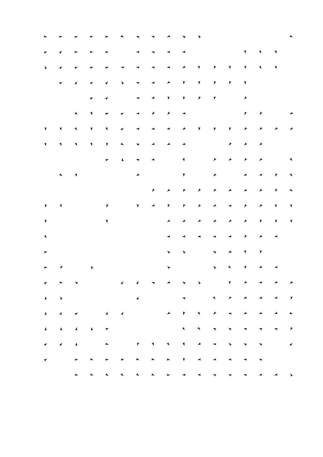
Flow direction of the cold air drainage (automatic grid adjustment)
Layer description:
The wind arrows ("flow direction of cold air") refer to the situation at 4 a.m. during a low-exchange radiation weather situation in summer. They are output at a height of 2 m above ground. The present wind arrows were aggregated (combined) from their original resolution of 25 m into a resolution of 25 m, 100 m , 200 m, 300 m, 500 m or 1000 m. The display is automatically adjusted to the respective zoom level (grid adjustment).
Explanation:
The present geodata are taken from the regional climate analysis of Luxembourg (GEO-NET & LIST 2021) which was published with the report « KLIMAÖKOLOGISCHE SITUATION IN LUXEMBURG“ - Modellbasierte regionale Klimaanalyse / (La situation au Luxembourg en matière d’écologie climatique) » by the Administration for Environment.
Source:
-> https://environnement.public.lu/fr/klima-an-energie/changement-climatique/klimaanalyse.html
Abstracts:
The Luxembourg regional climate, which is formed during a low-exchange radiative weather pattern in summer, was investigated using high-resolution computer-based modelling. In total, the model area is described with 8,272,693 grid cells, with information on terrain height, land use, structural height and degree of sealing stored for each grid cell. The urban climate model FITNAH-3D according to Groß (1992) forms the basic framework for the modelling. The input data and model results are based on a horizontal spatial resolution of 25 m x 25 m. The model results are presented in maps. The model results are presented in cartographic representations of the nocturnal temperature field, the nocturnal cold air flow field (4 a.m. in each case) and the thermal load during the day (2 p.m.) and concretised in the form of a climate analysis map.
The main product of the work process is a planning recommendation map with an associated catalogue of measures. On the one hand, the map makes visible the graduated need for action to improve thermal comfort in summer in all living/working and recreational areas (“load area”) of the population in Luxembourg. On the other hand, the planning recommendation map also assigns a value to all green and open spaces in the country ("compensation area") with regard to the climate-ecological functions they provide.
Notes:
- The geodata are only to be used in the context of the specific considerations of the above-mentioned report (e.g.: basic data as of 2018, specific meteorological framework conditions).
- The composition of the layers is based on the corresponding maps from the above-mentioned report. Even though these layers can be combined with any other layers from other thematic areas in the geoportal, it should be noted that these representations can easily lead to misinterpretations.
Simple
- Date (Creation)
- Invalid DateT00:00:00
- Date (Revision)
- Citation identifier
- / 8a11d9b4-2274-4505-8b03-ff9f075d7470
- Presentation form
- Digital map
- Status
- On going
- Point of contact
-
Organisation name Individual name Electronic mail address Role Administration du Cadastre et de la Topographie
Administration du Cadastre et de la Topographie
Author
- Maintenance and update frequency
- As needed
-
Entités au Grand-Duché de Luxembourg
-
-
Grand-Duché du Luxembourg
-
- Keywords
-
-
Flow direction of the cold air drainage (automatic grid adjustment); Climate analysis map
-
-
Geoportail.lu themes
-
-
Environment
-
-
Geoportail.lu structure
-
-
Environment>Climate protection
-
- Keywords
-
-
geoportail.lu
-
intranet
-
- Access constraints
- Other restrictions
- Spatial representation type
- Vector
- Denominator
- 500
- Character set
- UTF8
))
- Reference system identifier
- EPSG / http://www.opengis.net/def/crs/EPSG/0/2169
- Distribution format
-
Name Version ShapefileTODO
- OnLine resource
-
Protocol Linkage Name UKST
https://map.geoportail.lu/theme/emwelt?version=3&zoom=10&X=692693&Y=6407693&lang=fr&rotation=0&layers=2163&opacities=1&time=&bgLayer=basemap_2015_global&crosshair=false Flow direction of the cold air drainage (automatic grid adjustment)
WWW:LINK-1.0-http--link
https://data.public.lu/fr/datasets/climate-and-energy-the-climate-ecology-situation-in-luxembourg/ OGC:WMS-1.3.0-http-get-map
https://wms.geoportail.lu/public_map_layers/service 2163
- Hierarchy level
- Dataset
Metadata
- File identifier
- 7a2dabf0-a51d-4a37-be5e-24f679649a86 XML
- Metadata language
- Français
- Character set
- UTF8
- Hierarchy level
- Dataset
- Hierarchy level name
-
dataset
- Date stamp
- 2025-02-19T09:51:45
- Metadata standard name
-
ISO 19115:2003/19139
- Metadata standard version
-
1.0
- Metadata author
-
Organisation name Individual name Electronic mail address Role Administration de l'environnement
Luc Lieffring
Administration de l'Environnement
- Other language
-
Language Character encoding Luxembourgish; Letzeburgesch UTF8 English UTF8 German UTF8 French UTF8
)))