 geocatalogue.geoportail.lu
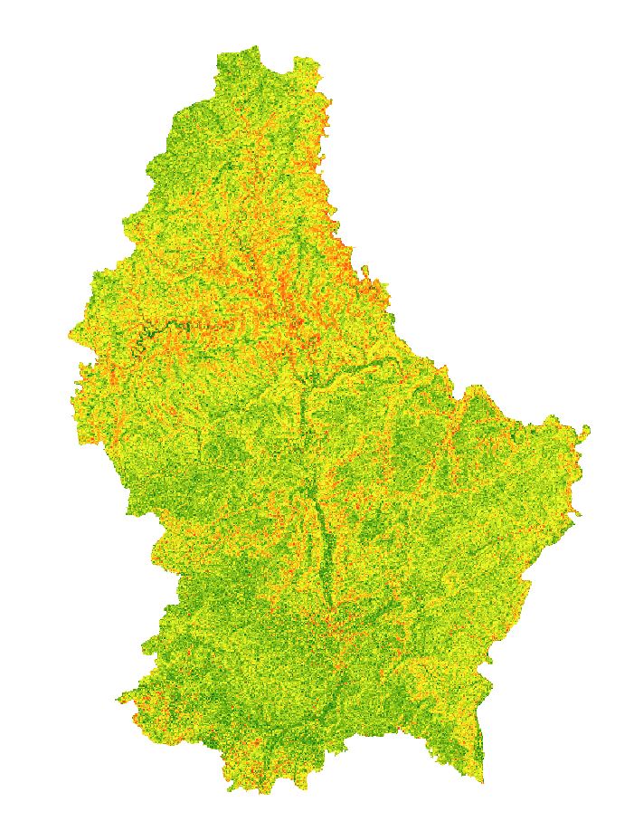
Pente (MNT) 2024
Hangneigung (MNT) 2024
Slope (DEM) 2024
Hangneigung (DGM) 2024
Pente colorée basée sur le modèle numérique de terrain de 2024 avec une résolution au sol de 50cm.
Gefierwte Raster vun der Hangneigung a Grad, deen op dem digitalen Héichtenmodell vun 2024 baséiert an eng Buedemopléisung vun 50cm huet.
Colorized raster of the slope in degrees based on the digital elevation model of 2024 with a resolution of 50cm.
Gefärbtes Raster der Hangneigung in Grad, basierend auf dem digitalen Höhenmodell von 2024 mit einer Auflösung von 50cm.
Simple
-
Date (Création)Date (Creation)Datumsangaben (Erstellung)Date (Création)
- 2025-01-13T00:00:00
-
IdentificateurCitation identifierIdentifikatorIdentificateur
- / 6ffa94a4-af02-43ec-82e0-6796cd01a948
-
Forme de la présentationPresentation formPräsentationsformForme de la présentation
-
Carte numériqueDigital mapDigitale KarteCarte numérique
-
EtatStatusBearbeitungsstatusEtat
-
Mise à jour continueOn goingKontinuierliche AktualisierungMise à jour continue
-
Fréquence de mise à jourMaintenance and update frequencyÜberarbeitungsintervallFréquence de mise à jour
-
Lorsque nécessaireAs neededBei BedarfLorsque nécessaire
-
Entités au Grand-Duché de Luxembourg
-
-
Grand-Duché du Luxembourg
Grand-Duché du Luxembourg
Grand-Duché du Luxembourg
Grand-Duché du Luxembourg
-
- Keywords
-
-
Grand-Duché de Luxembourg, Lidar, Pente, Modèle numérique de terrain, Relief, Géodonnées
Groussherzogtum Lëtzebuerg, Lidar, Hangneigung, Digitalen Héichtemodell, Relief, Geodaten
Grand Duchy of Luxembourg, Lidar, Slope, Digital elevation model, Relief, Geodata
Großherzogtum Luxemburg, Lidar, Hangneigung, Digitales Höhenmodell, Relief, Geodaten
-
- Keywords
-
-
geoportail.lu
geoportail.lu
geoportail.lu
geoportail.lu
-
-
geoportail.lu themes
-
-
Grand Public
Allgemeng
Main
Allgemein
-
-
geoportail.lu structure
-
-
Grand Public>Couverture du sol>Morphométrie
Grand Public>Couverture du sol>Morphométrie>Morphologie
Main>Land surface>Morphometric attributes
Allgemein>Oberflächendarstellung>Morphometrie
-
-
Contraintes d'accèsAccess constraintsZugriffseinschränkungenContraintes d'accès
-
Autres restrictionsOther restrictionsBenutzerdefinierte EinschränkungenAutres restrictions
-
Type de représentation spatialeSpatial representation typeRäumliche DarstellungsartType de représentation spatiale
-
VecteurVectorVektorVecteur
-
Dénominateur de l'échelleDenominatorMaßstabszahlDénominateur de l'échelle
- 0
-
Encodage des caractèresCharacter setZeichensatzEncodage des caractères
-
Utf8UTF8Utf8Utf8
))
-
Nom du système de référenceReference system identifierIdentifikator des ReferenzsystemsNom du système de référence
- EPSG / http://www.opengis.net/def/crs/EPSG/0/2169
- OnLine resource
-
Protocol Linkage Name OGC:WMS-1.3.0-http-get-map
https://wms.geoportail.lu/public_map_layers/service 1461
1461
1461
1461
https://map.geoportail.lu/theme/main?version=3&zoom=8&X=667917&Y=6394482&lang=fr&layers=1461&opacities=1 Pente (MNT) 2024
Hangneigung (MNT) 2024
Slope (DEM) 2024
Hangneigung (DGM) 2024
Metadata
-
Identifiant de la ficheFile identifierMetadatensatzidentifikatorIdentifiant de la fiche
- 6ffa94a4-af02-43ec-82e0-6796cd01a948 XML
-
LangueMetadata languageSpracheLangue
- Français
-
Jeu de caractèresCharacter setZeichensatzJeu de caractères
-
Utf8UTF8Utf8Utf8
-
Type de ressourceHierarchy levelHierarchieebeneType de ressource
-
Jeu de donnéesDatasetDatenbestandJeu de données
- Hierarchy level name
-
dataset
-
Date des métadonnéesDate stampDatumDate des métadonnées
- 2025-01-22T14:30:45
- Metadata standard name
-
ISO 19115:2003/19139
- Metadata standard version
-
1.0
- Metadata author
-
Organisation name Individual name Electronic mail address Role Administration du Cadastre et de la Topographie
Service Géoportail
Point de contactPoint of contactAnsprechpartnerPoint de contact
- Other language
-
Language Character encoding LëtzebuergeschLuxembourgish; LetzeburgeschLuxemburgischLuxembourgeoisUtf8UTF8Utf8Utf8EngleschEnglishEnglischAnglaisUtf8UTF8Utf8Utf8DäitschGermanDeutschAllemandUtf8UTF8Utf8Utf8FranséischFrenchFranzösischFrançaisUtf8UTF8Utf8Utf8
)))