 geocatalogue.geoportail.lu
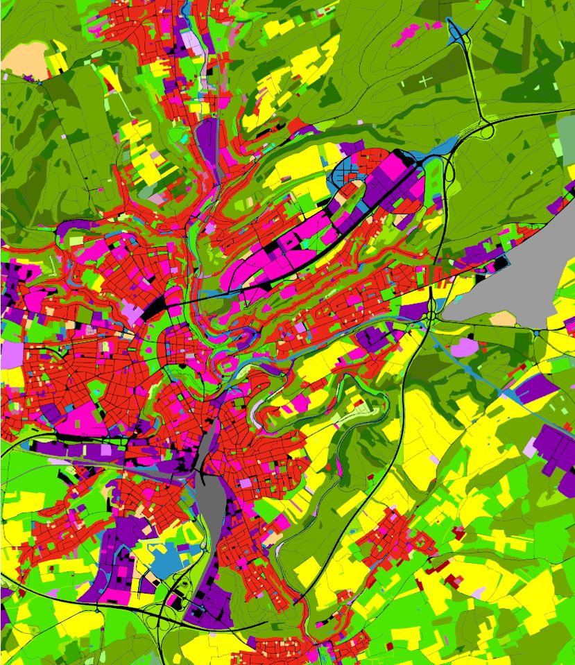
Utilisation du sol 2015
Landnotzung 2015
Land Use 2015
Landnutzung 2015
L’utilisation du sol selon la dimension fonctionnelle renvoie à la description des zones selon leur finalité socio-économique
D'Buedemnotzung no senger funktioneller Dimensioun entsprécht enger Beschreiwung vu Flächen opgrond hirem sozioekonomeschen Zweck
Land Use in terms of functional dimension corresponds to the description of areas in terms of their socio-economic purpose
Die Bodennutzung in Hinblick auf die funktionale Dimension entspricht der Beschreibung von Gebieten bezüglich ihres sozioökonomischen Zwecks
Simple
-
IdentificateurCitation identifierIdentifikatorIdentificateur
- / 65e04718-1890-4c5e-8be7-08a73f69c0cc
-
Forme de la présentationPresentation formPräsentationsformForme de la présentation
-
Carte numériqueDigital mapDigitale KarteCarte numérique
-
EtatStatusBearbeitungsstatusEtat
-
Mise à jour continueOn goingKontinuierliche AktualisierungMise à jour continue
-
Fréquence de mise à jourMaintenance and update frequencyÜberarbeitungsintervallFréquence de mise à jour
-
Lorsque nécessaireAs neededBei BedarfLorsque nécessaire
-
Entités au Grand-Duché de Luxembourg
-
-
Grand-Duché du Luxembourg
Grand-Duché du Luxembourg
Grand-Duché du Luxembourg
Grand-Duché du Luxembourg
-
- Keywords
-
- Keywords
-
-
geoportail.lu
geoportail.lu
geoportail.lu
geoportail.lu
-
Utilisation du sol
Landnotzung
Land Use
Landnutzung
-
-
geoportail.lu themes
-
-
Environnement
Emwelt
Environment
Umwelt
-
Grand Public
Allgemeng
Main
Allgemein
-
-
geoportail.lu structure
-
-
Environnement>Utilisation et couverture du sol>LIS-L Utilisation du sol
Environnement>Landnotzung a Landbedeckungl>LIS-L Landnotzung
Environment>Land Use and Land Cover>LIS-L Land Use
Umwelt>Landnutzung und Landbedeckung>LIS-L Landnutzung
-
Grand Public>Couverture du sol>Utilisation et couverture du sol>LIS-L Utilisation du sol
Grand Public>Couverture du sol>Landnotzung a Landbedeckungl>LIS-L Landnotzung
Main>Land surface>Land Use and Land Cover>LIS-L Land Use
Allgemein>Oberflächendarstellung>Landnutzung und Landbedeckung>LIS-L Landnutzung
-
-
Contraintes d'accèsAccess constraintsZugriffseinschränkungenContraintes d'accès
-
Autres restrictionsOther restrictionsBenutzerdefinierte EinschränkungenAutres restrictions
-
Type de représentation spatialeSpatial representation typeRäumliche DarstellungsartType de représentation spatiale
-
VecteurVectorVektorVecteur
-
Dénominateur de l'échelleDenominatorMaßstabszahlDénominateur de l'échelle
- 0
-
Encodage des caractèresCharacter setZeichensatzEncodage des caractères
-
Utf8UTF8Utf8Utf8
))
-
Nom du système de référenceReference system identifierIdentifikator des ReferenzsystemsNom du système de référence
-
EPSG
/
http://www.opengis.net/def/crs/EPSG/0/2169
- OnLine resource
-
Protocol Linkage Name OGC:WMS-1.3.0-http-get-map
https://wms.geoportail.lu/public_map_layers/service 2054
2054
2054
2054
UKST
https://map.geoportail.lu/theme/emwelt?version=3&zoom=10&X=698582&Y=6412881&lang=fr&rotation=0&layers=2054&opacities=1&bgLayer=basemap_2015_global&crosshair=false Utilisation du sol 2015
Landnotzung 2015
Land Use 2015
Landnutzung 2015
WWW:LINK-1.0-http--link
https://data.public.lu/fr/datasets/lis-l-land-use-2007-2015-2018/ OGC API-Features
https://features.geoportail.lu/collections/2054 OGC API - Features
Metadata
-
Identifiant de la ficheFile identifierMetadatensatzidentifikatorIdentifiant de la fiche
- 65e04718-1890-4c5e-8be7-08a73f69c0cc XML
-
LangueMetadata languageSpracheLangue
- Français
-
Jeu de caractèresCharacter setZeichensatzJeu de caractères
-
Utf8UTF8Utf8Utf8
-
Type de ressourceHierarchy levelHierarchieebeneType de ressource
-
Jeu de donnéesDatasetDatenbestandJeu de données
- Hierarchy level name
-
dataset
-
Date des métadonnéesDate stampDatumDate des métadonnées
- 2021-06-18T14:50:25Z
- Metadata standard name
-
ISO 19115:2003/19139
- Metadata standard version
-
1.0
- Metadata author
-
Organisation name Individual name Electronic mail address Role Département de l'aménagement du territoire
Ministère de l’Environnement, du Climat et du Développement durable & Ministère de l’Énergie et de l’Aménagement du territoire
Point de contactPoint of contactAnsprechpartnerPoint de contact
- Other language
-
Language Character encoding LëtzebuergeschLuxembourgish; LetzeburgeschLuxemburgischLuxembourgeoisUtf8UTF8Utf8Utf8EngleschEnglishEnglischAnglaisUtf8UTF8Utf8Utf8DäitschGermanDeutschAllemandUtf8UTF8Utf8Utf8FranséischFrenchFranzösischFrançaisUtf8UTF8Utf8Utf8
)))