 geocatalogue.geoportail.lu
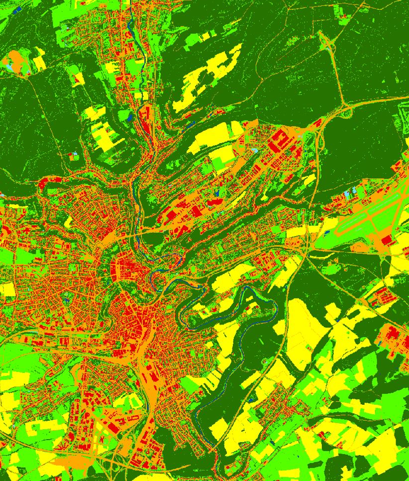
Couverture du sol 2018
Landbedeckung 2018
Land Cover 2018
Landbedeckung 2018
La couverture du sol est une description physique de l’espace – l’occupation (bio)physique observée de la surface terrestre, c’est-à-dire ce qui recouvre le sol
D'Landnotzung entsprécht enger physescher Beschreiwung vum Raum, vun der observéierter (bio-)physescher Bedeckung vun der Äerduewerfläch. Se gëtt un wat op dem Buedem ass a wat en grad bedeckt
Land Cover corresponds to a physical description of space, the observed (bio)physical cover of the earth's surface . It is that which overlays or currently covers the ground
Die Bodenbedeckung entspricht einer physischen Beschreibung des Raums, der beobachteten (bio-)physischen Bedeckung der Erdoberfläche. Sie gibt an, was über dem Boden liegt oder ihn gerade bedeckt
Simple
-
Date (Publication)Date (Publication)Datumsangaben (Publikation)Date (Publication)
- 2021-05-14
-
IdentificateurCitation identifierIdentifikatorIdentificateur
- / dbdf6d8f-476f-4839-86a3-c53f8c286385
-
EtatStatusBearbeitungsstatusEtat
-
Mise à jour continueOn goingKontinuierliche AktualisierungMise à jour continue
Contact pour la ressource
Point of contact
Kontakt für die Ressource
Contact pour la ressource
-
Fréquence de mise à jourMaintenance and update frequencyÜberarbeitungsintervallFréquence de mise à jour
-
Lorsque nécessaireAs neededBei BedarfLorsque nécessaire
-
Entités au Grand-Duché de Luxembourg
-
-
Grand-Duché du Luxembourg
Grand-Duché du Luxembourg
Grand-Duché du Luxembourg
Grand-Duché du Luxembourg
-
- Keywords
-
-
geoportail.lu
geoportail.lu
geoportail.lu
geoportail.lu
-
Couverture du sol
Landbedeckung, Bodenbedeckung
Landcover
Landbedeckung, Bodenbedeckung
-
-
geoportail.lu themes
-
-
Environnement
Emwelt
Environment
Umwelt
-
Grand Public
Allgemeng
Main
Allgemein
-
-
geoportail.lu structure
-
-
Environnement>Utilisation et couverture du sol>LIS-L Couverture du sol
Environnement>Landnotzung a Landbedeckung>LIS-L Landbedeckung
Environment>Land Use and Land Cover>LIS-L Land Cover
Umwelt>Landnutzung und Landbedeckung>LIS-L Landbedeckung
-
Grand Public>Couverture du sol>Utilisation et couverture du sol>LIS-L Couverture du sol
Grand Public>Couverture du sol>Landnotzung a Landbedeckung>LIS-L Landbedeckung
Main>Land surface>Land Use and Land Cover>LIS-L Land Cover
Allgemein>Oberflächendarstellung>Landnutzung und Landbedeckung>LIS-L Landbedeckung
-
-
Type de représentation spatialeSpatial representation typeRäumliche DarstellungsartType de représentation spatiale
-
VecteurVectorVektorVecteur
-
Langue de la ressourceLanguageSpracheLangue de la ressource
- Français
))
-
Nom du système de référenceReference system identifierIdentifikator des ReferenzsystemsNom du système de référence
- EPSG / http://www.opengis.net/def/crs/EPSG/0/2169
- OnLine resource
-
Protocol Linkage Name OGC:WMS-1.3.0-http-get-map
https://wms.geoportail.lu/public_map_layers/service 1951
1951
1951
1951
WWW:LINK-1.0-http--link
https://data.public.lu/fr/datasets/lis-l-land-cover-2018/
- OnLine resource
-
Protocol Linkage Name https://map.geoportail.lu/theme/main?version=3&zoom=8&X=667917&Y=6394482&lang=fr&layers=1951&opacities=1 Couverture du sol 2018
Landbedeckung 2018
Land Cover 2018
Landbedeckung 2018
Metadata
-
Identifiant de la ficheFile identifierMetadatensatzidentifikatorIdentifiant de la fiche
- 6142a6a6-9356-47ac-babe-eaa2ae3628b6 XML
-
LangueMetadata languageSpracheLangue
- Français
-
Jeu de caractèresCharacter setZeichensatzJeu de caractères
-
Utf8UTF8Utf8Utf8
-
Type de ressourceHierarchy levelHierarchieebeneType de ressource
-
Jeu de donnéesDatasetDatenbestandJeu de données
- Hierarchy level name
-
dataset
-
Date des métadonnéesDate stampDatumDate des métadonnées
- 2021-06-18T14:52:19
- Metadata standard name
-
ISO 19115:2003/19139:2007
- Metadata standard version
-
1.0
Contact
Metadata author
Metadatenkontakt
Contact
- Other language
-
Language Character encoding LëtzebuergeschLuxembourgish; LetzeburgeschLuxemburgischLuxembourgeoisUtf8UTF8Utf8Utf8EngleschEnglishEnglischAnglaisUtf8UTF8Utf8Utf8DäitschGermanDeutschAllemandUtf8UTF8Utf8Utf8FranséischFrenchFranzösischFrançaisUtf8UTF8Utf8Utf8
)))