 geocatalogue.geoportail.lu
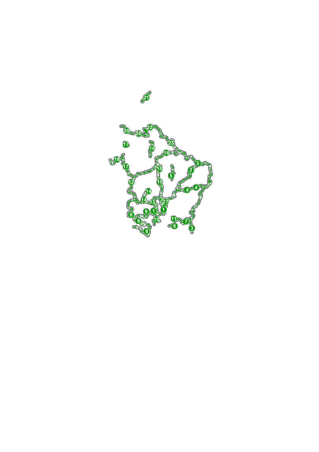
Réseau cyclable national
National Velosweeër
National Cycling paths
Nationale Fahrradwege
Réseau cyclable national réalisé et entretenu par l’Administration des Ponts des Chaussées conformément à la loi du 28 avril 2015. <a href=" http://www.pistescyclables.lu">http://www.pistescyclables.lu</a>
Simple
-
Date (Création)Date (Creation)Datumsangaben (Erstellung)Date (Création)
- 2013-09-18T00:00:00
-
Date (Révision)Date (Revision)Datumsangaben (Überarbeitung)Date (Révision)
- 2013-09-18T00:00:00
-
IdentificateurCitation identifierIdentifikatorIdentificateur
- / 387f6949-0fc4-43a5-b0e6-4e09bdf65225
-
Forme de la présentationPresentation formPräsentationsformForme de la présentation
-
Carte numériqueDigital mapDigitale KarteCarte numérique
-
EtatStatusBearbeitungsstatusEtat
-
Mise à jour continueOn goingKontinuierliche AktualisierungMise à jour continue
- Point of contact
-
Organisation name Individual name Electronic mail address Role Administration des Ponts et Chaussées
Division de la mobilité durable
Point de contactPoint of contactAnsprechpartnerPoint de contact
-
Fréquence de mise à jourMaintenance and update frequencyÜberarbeitungsintervallFréquence de mise à jour
-
Lorsque nécessaireAs neededBei BedarfLorsque nécessaire
-
Entités au Grand-Duché de Luxembourg
-
-
Grand-Duché du Luxembourg
Grand-Duché du Luxembourg
Grand-Duché du Luxembourg
Grand-Duché du Luxembourg
-
- Keywords
-
- Keywords
-
-
réseau cyclable national
Velo
Bicycle
Fahrrad
-
pistes cyclables nationales
-
pc
-
itinéraires cyclables
-
itinéraires cyclables nationaux
-
geoportail.lu
geoportail.lu
geoportail.lu
geoportail.lu
-
-
geoportail.lu themes
-
-
Tourisme
Tourismus
Tourism
Tourismus
-
Lenoz
Lenoz
Lenoz
Lenoz
-
Grand Public
Allgemeng
Main
Allgemein
-
PAG
PAG
PAG
PAG
-
-
geoportail.lu structure
-
-
Tourisme>Itinéraires cyclables et VTT
Tourisme>Itinéraires cyclables et VTT>Vëlos- & Mountainbike Weeër
Tourism>Cycling & Mountainbike Trails
Tourismus>Rad- und Mountainbike Wege
-
Lenoz>Lenoz
Lenoz>Lenoz>Lenoz
Lenoz>Lenoz
Lenoz>Lenoz
-
Grand Public>Infrastructure et communication>Réseaux de transport
Grand Public>Infrastructure et communication>Réseaux de transport>Verkéiersnetzer
Main>Infrastructure and communication>Transport networks
Allgemein>Infrastruktur und Kommunikation>Verkehrsnetze
-
PAG>Données nationales de planification>Réseaux de transport
PAG>Données nationales de planification>Réseaux de transport>Verkéiersnetzer
PAG>National planning data>Transport networks
PAG>Nationale Planungsdaten>Verkehrsnetze
-
-
Contraintes d'utilisationUse constraintsNutzungseinschränkungenContraintes d'utilisation
-
Autres restrictionsOther restrictionsBenutzerdefinierte EinschränkungenAutres restrictions
-
Autres contraintes
-
Creative Commons 1.0 Universal (CC0 1.0) Public Domain Dedication
-
Type de représentation spatialeSpatial representation typeRäumliche DarstellungsartType de représentation spatiale
-
VecteurVectorVektorVecteur
-
Dénominateur de l'échelleDenominatorMaßstabszahlDénominateur de l'échelle
- 1000
-
Langue de la ressourceLanguageSpracheLangue de la ressource
- Français
-
Encodage des caractèresCharacter setZeichensatzEncodage des caractères
-
Utf8UTF8Utf8Utf8
-
Catégorie ISOTopic categoryISO-ThematikCatégorie ISO
-
-
Infrastructures de transportTransportationVerkehrswesenInfrastructures de transport
-
))
-
Nom du système de référenceReference system identifierIdentifikator des ReferenzsystemsNom du système de référence
-
EPSG
/
http://www.opengis.net/def/crs/EPSG/0/2169
- OnLine resource
-
Protocol Linkage Name OGC:WMS-1.3.0-http-get-map
https://wms.geoportail.lu/public_map_layers/service 808
808
808
808
WWW:LINK-1.0-http--link
https://data.public.lu/fr/datasets/tourisme-geoportail-lu-pistes-cyclables-nationales/ OGC API-Features
https://features.geoportail.lu/collections/808 OGC API - Features
- OnLine resource
-
Protocol Linkage Name https://map.geoportail.lu/theme/main?version=3&zoom=8&X=667917&Y=6394482&lang=fr&layers=808&opacities=1 Pistes cyclables nationales
National Velosweeër
National cycling paths
Nationale Radwege
Metadata
-
Identifiant de la ficheFile identifierMetadatensatzidentifikatorIdentifiant de la fiche
- 387f6949-0fc4-43a5-b0e6-4e09bdf65225 XML
-
LangueMetadata languageSpracheLangue
- Français
-
Jeu de caractèresCharacter setZeichensatzJeu de caractères
-
Utf8UTF8Utf8Utf8
-
Type de ressourceHierarchy levelHierarchieebeneType de ressource
-
Jeu de donnéesDatasetDatenbestandJeu de données
- Hierarchy level name
-
dataset
-
Date des métadonnéesDate stampDatumDate des métadonnées
- 2021-02-04T22:15:16Z
- Metadata standard name
-
ISO 19115:2003/19139
- Metadata standard version
-
1.0
- Metadata author
-
Organisation name Individual name Electronic mail address Role Administration des Ponts et Chaussées
Division de la mobilité durable
Point de contactPoint of contactAnsprechpartnerPoint de contact
- Other language
-
Language Character encoding LëtzebuergeschLuxembourgish; LetzeburgeschLuxemburgischLuxembourgeoisUtf8UTF8Utf8Utf8EngleschEnglishEnglischAnglaisUtf8UTF8Utf8Utf8DäitschGermanDeutschAllemandUtf8UTF8Utf8Utf8FranséischFrenchFranzösischFrançaisUtf8UTF8Utf8Utf8
)))