 geocatalogue.geoportail.lu
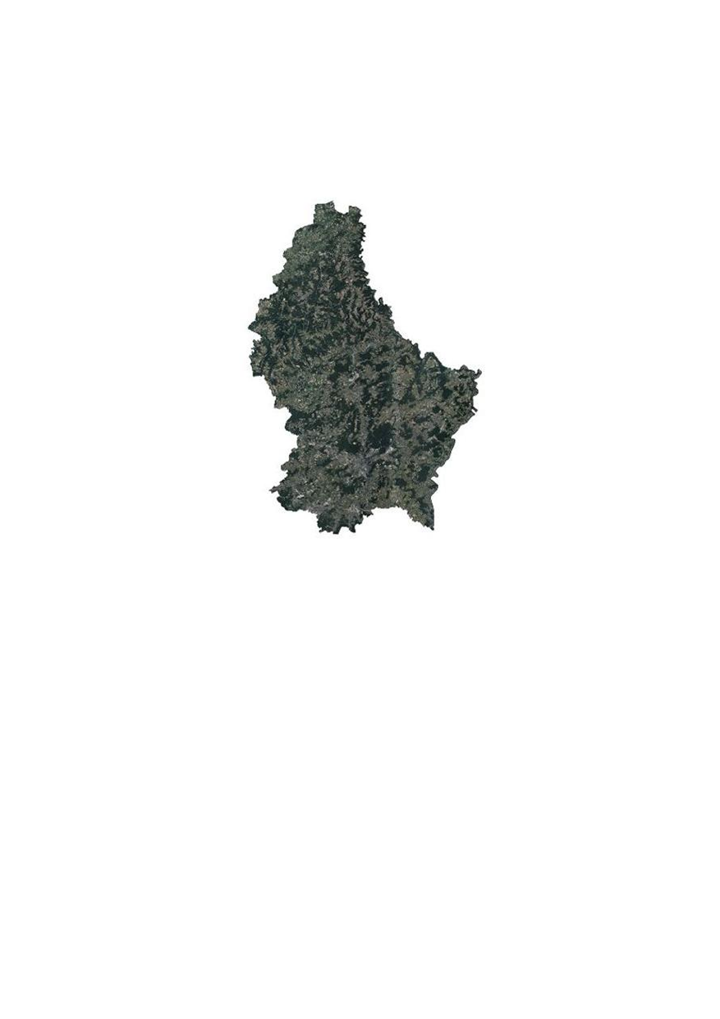
Orthophoto 2017 de l'administration du cadastre et de la topographie
Orthophoto 2017 vun der Kadaster- an Topgraphieverwaltung
Orthophoto 2017 of the land registry and topography administration
Orthophoto 2017 der Kataster- und Topographieverwaltung
Cette couche contient les orthophotos officielles couvrant le territoire national. 4 vols ont été réalisés les 14, 19 et 20 juin 2017, proches du solstice d'été, avec une élévation solaire > 35°. La résolution au sol native est <0,20m GSD (Ground Sampling Distance). Le déversement sur image, général est <25cm, alors que le déversement sur la Ville de Luxembourg est <15cm, pour une zone de 10x9 km soit 90km2 centrée sur les coordonnées Est 78000 et Nord 74500. La couverture du Grand Duché du Luxembourg est assurée avec un débord de 50m au-delà de la limite d'Etat.
Dëse Layer enthält déi offiziell Orthophoto vum Territoire vu Lëtzebuerg. 4 Iwwerfléiungen sin den 14., 19. an 20. Juni 2017, kuerz virum Solstice, bei engem Sonnestand vun > 35° duerchgefouert ginn. D'Opléisung vun den Pixelen um Buedem läit bei <0,20m GSD (Ground Sampling Distance). Den Bildsturz läit beim ganzen Land bei <25%, mat Ausnam vun der Stad Lëtzebuerg, wou en op engem Gebitt vun 10x9 km (90km2, zentréiert op den Koordinaten 78000 Ost an 74500 Nord) bei <15% läit. Op den Grenzen gëtt en Gebitt vun 50m iwwert d'Landesgrenzen eraus mat erfaasst.
This layer contains the official orthophotos covering the national territory of Luxembourg. The 4 surveying flights took place on 14, 19 and 20 June 2017, close to the solstice, with a sun position of > 35°. The ground sampling distance is <0,20m. The perspective displacement is in general <25%, except for Luxembourg-City, where it is <15% for a zone of 10x9km (90km2, centered on the coordinates 78000 east and 74500 north). On the borders, a zone of 50m behind the country border is included.
Dieser Layer enthält die amtlichen Orthophotos vom gesamten Gebiet des Großherzogtums Luxemburg. 4 Überfliegungen wurden am 14., 19. und 20. Juni 2017, nahe der Sommersonnenwende bei einem Sonnenstand von > 35° durchgeführt. Die Bodenauflösung liegt bei <0,20m GSD (Ground Sampling Distance). Der Bildsturz liegt für das ganze Land bei <25%, mit Ausnahme von Luxemburg-Stadt, wo er auf einem Gebiet von 10x9 km (90km2, zentriert auf den Koordinaten 78000 Ost und 74500 Nord) bei <15% liegt. An den Grenzen wird ein Gebiet bis 50m über die Landesgrenzen hinaus mit abgedeckt.
Simple
-
IdentificateurIdentificateurCitation identifierIdentifikator
- / 1cdae616-1a7a-49d5-b35d-05864891641f
-
Forme de la présentationForme de la présentationPresentation formPräsentationsform
-
Carte numériqueCarte numériqueDigital mapDigitale Karte
-
EtatEtatStatusBearbeitungsstatus
-
Mise à jour continueMise à jour continueOn goingKontinuierliche Aktualisierung
- Point of contact
-
Organisation name Individual name Electronic mail address Role Administration du Cadastre et de la Topographie
Administration du Cadastre et de la Topographie
Point de contactPoint de contactPoint of contactAnsprechpartner
-
Fréquence de mise à jourFréquence de mise à jourMaintenance and update frequencyÜberarbeitungsintervall
-
Lorsque nécessaireLorsque nécessaireAs neededBei Bedarf
-
Entités au Grand-Duché de Luxembourg
-
-
Grand-Duché du Luxembourg
Grand-Duché du Luxembourg
Grand-Duché du Luxembourg
Grand-Duché du Luxembourg
-
- Keywords
-
- Keywords
-
-
orthophoto
Orthophoto
Orthophoto
Orthophoto
-
image
Loftbild
aerial
Luftbild
-
aérienne
Loftopnam
photograph
Luftaufnahme
-
géodonnée
Geodaten
geodata
Geodaten
-
2017
2017
2017
2017
-
geoportail.lu
geoportail.lu
geoportail.lu
geoportail.lu
-
-
geoportail.lu themes
-
-
Grand Public
Allgemeng
Main
Allgemein
-
Eau
Wasser
Water
Wasser
-
-
geoportail.lu structure
-
-
Grand Public>Couverture du sol>Images aériennes et satellites
Grand Public>Couverture du sol>Images aériennes et satellites>Loft- a Satellitebiller
Main>Land surface>Orthophoto-images
Allgemein>Oberflächendarstellung>Luft und Satellitenbilder
-
Eau>Données de base>Photographies aériennes et spatiales
Eau>Données de base>Photographies aériennes et spatiales>Loft- an Satellitebiller
Water>Geographical location>Aerial and satellite photographs
Wasser>Basisdaten>Luft- und Satellitenbilder
-
-
Contraintes d'utilisationContraintes d'utilisationUse constraintsNutzungseinschränkungen
-
Autres restrictionsAutres restrictionsOther restrictionsBenutzerdefinierte Einschränkungen
- Other constraints
-
Creative Commons 1.0 Universal (CC0 1.0) Public Domain Dedication
-
Type de représentation spatialeType de représentation spatialeSpatial representation typeRäumliche Darstellungsart
-
VecteurVecteurVectorVektor
-
Dénominateur de l'échelleDénominateur de l'échelleDenominatorMaßstabszahl
- 0
-
Encodage des caractèresEncodage des caractèresCharacter setZeichensatz
-
Utf8Utf8UTF8Utf8
))
-
Nom du système de référenceNom du système de référenceReference system identifierIdentifikator des Referenzsystems
- EPSG / http://www.opengis.net/def/crs/EPSG/0/2169
- OnLine resource
-
Protocol Linkage Name OGC:WMS-1.3.0-http-get-map
https://wms.geoportail.lu/public_map_layers/service 1371
1371
1371
1371
OGC:WMS-1.3.0-http-get-map
http://wmts1.geoportail.lu/opendata/service?request=getCapabilities&service=WMS&version=1.3.0 ortho_2017
WWW:LINK-1.0-http--link
https://data.public.lu/fr/datasets/orthophoto-officelle-du-grand-duche-de-luxembourg-edition-2017/
- OnLine resource
-
Protocol Linkage Name https://map.geoportail.lu/theme/main?version=3&zoom=8&X=667917&Y=6394482&lang=fr&layers=1371&opacities=1 Orthophoto 2017
Orthophoto 2017
Orthophoto 2017
Orthophoto 2017
Metadata
-
Identifiant de la ficheIdentifiant de la ficheFile identifierMetadatensatzidentifikator
- 1cdae616-1a7a-49d5-b35d-05864891641f XML
-
LangueLangueMetadata languageSprache
- Français
-
Jeu de caractèresJeu de caractèresCharacter setZeichensatz
-
Utf8Utf8UTF8Utf8
-
Type de ressourceType de ressourceHierarchy levelHierarchieebene
-
Jeu de donnéesJeu de donnéesDatasetDatenbestand
- Hierarchy level name
-
dataset
-
Date des métadonnéesDate des métadonnéesDate stampDatum
- 2021-02-04T22:21:25
- Metadata standard name
-
ISO 19115:2003/19139
- Metadata standard version
-
1.0
- Metadata author
-
Organisation name Individual name Electronic mail address Role Administration du Cadastre et de la Topographie
Administration du Cadastre et de la Topographie
Point de contactPoint de contactPoint of contactAnsprechpartner
- Other language
-
Language Character encoding FrançaisFranséischFrenchFranzösischUtf8Utf8UTF8Utf8LuxembourgeoisLëtzebuergeschLuxembourgish; LetzeburgeschLuxemburgischUtf8Utf8UTF8Utf8AnglaisEngleschEnglishEnglischUtf8Utf8UTF8Utf8AllemandDäitschGermanDeutschUtf8Utf8UTF8Utf8
)))