 geocatalogue.geoportail.lu
Peste porcine africaine: zonage
African swine fever: zoning
Afrikanische Schweinepest: Zonierung
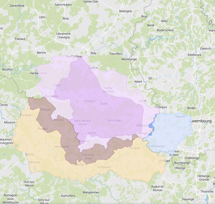
Zonage pour la lutte contre la peste porcine africaine en Wallonie, Grand Est et Luxembourg
- Sources: SPW DEMNA (Wallonie), ANF (Luxembourg), DRAAF (Grand Est)
Zoning for the control of African swine fever in Wallonia, Grand Est and Luxembourg
- Sources: SPW DEMNA (Wallonie), ANF (Luxembourg), DRAAF (Grand Est)
Zonierung zur Bekämpfung der Afrikanischen Schweinepest in der Wallonie, in Grand Est und Luxemburg
- Quellen: SPW DEMNA (Wallonie), ANF (Luxemburg), DRAAF (Grand Est)
Simple
-
Date (Creation)Datumsangaben (Erstellung)Date (Création)
- 2019-03-28T00:00:00
-
Date (Revision)Datumsangaben (Überarbeitung)Date (Révision)
- 2022-02-24T00:00:00
-
Citation identifierIdentifikatorIdentificateur
- / 14f72fb3-fb08-408b-992b-a0bbad9286f1
-
Presentation formPräsentationsformForme de la présentation
-
Digital mapDigitale KarteCarte numérique
-
StatusBearbeitungsstatusEtat
-
CompletedAbgeschlossenFinalisé
-
Maintenance and update frequencyÜberarbeitungsintervallFréquence de mise à jour
-
ContinualKontinuierlichContinue
- Keywords
-
-
Peste porcine, zonage
Swine fever, zoning
Schweinepest, Zonierung
-
-
Entités dans la Grande Région
-
-
Grande Région
Greater Region
Großregion
-
-
gis-gr.eu themes
-
-
Agriculture
Agriculture
Landwirtschaft
-
-
gis-gr.eu structure
-
-
Agriculture>Peste porcine africaine
Agriculture>African swine fever
Landwirtschaft>Afrikanische Schweinepest
-
- Keywords
-
-
gis-gr.eu
gis-gr.eu
gis-gr.eu
-
-
Access constraintsZugriffseinschränkungenContraintes d'accès
-
Other restrictionsBenutzerdefinierte EinschränkungenAutres restrictions
-
Spatial representation typeRäumliche DarstellungsartType de représentation spatiale
-
VectorVektorVecteur
-
DenominatorMaßstabszahlDénominateur de l'échelle
- 100000
-
LanguageSpracheLangue de la ressource
- Deutsch
-
LanguageSpracheLangue de la ressource
- Français
-
LanguageSpracheLangue de la ressource
- English
-
Character setZeichensatzEncodage des caractères
-
UTF8Utf8Utf8
-
Topic categoryISO-ThematikCatégorie ISO
-
-
BoundariesGrenzenLimites politiques et administratives
-
BiotaBiologieBiologie, faune et flore
-
FarmingLandwirtschaftAgriculture
-
))
-
Reference system identifierIdentifikator des ReferenzsystemsNom du système de référence
- EPSG / http://www.opengis.net/def/crs/EPSG/0/3857
- Distribution format
-
Name Version PDF
JPEG
SHAPE
- OnLine resource
-
Protocol Linkage Name OGC:WMS-1.3.0-http-get-map
https://ws.geoportail.lu/wss/service/GR_Agriculture_WMS/guest African_swine_fever_zoning_Luxembourg
WWW:LINK-1.0-http--samples
https://map.gis-gr.eu/theme/agriculture?version=3&zoom=8&X=667917&Y=6394482&lang=en&layers=1814&opacities=1&bgLayer=basemap_2015_global Carte interactive
Interactive map
Interaktive Karte
OGC:WMS-1.3.0-http-get-map
https://ws.geoportail.lu/wss/service/GR_Agriculture_WMS/guest African_swine_fever_zoning_France
OGC:WMS-1.3.0-http-get-map
https://ws.geoportail.lu/wss/service/GR_Agriculture_WMS/guest African_swine_fever_zoning_Wallonia
OGC:WFS
https://ws.geoportail.lu/wss/service/GR_Agriculture_WFS/guest Agriculture:African_swine_fever_fence_Wallonia
OGC:WFS
https://ws.geoportail.lu/wss/service/GR_Agriculture_WFS/guest Agriculture:African_swine_fever_fence_France
OGC:WFS
https://ws.geoportail.lu/wss/service/GR_Agriculture_WFS/guest Agriculture:African_swine_fever_fence_Luxembourg
Metadata
-
File identifierMetadatensatzidentifikatorIdentifiant de la fiche
- 14f72fb3-fb08-408b-992b-a0bbad9286f1 XML
-
Metadata languageSpracheLangue
- Français
-
Character setZeichensatzJeu de caractères
-
UTF8Utf8Utf8
-
Hierarchy levelHierarchieebeneType de ressource
-
DatasetDatenbestandJeu de données
- Hierarchy level name
-
dataset
-
Date stampDatumDate des métadonnées
- 2025-01-10T08:56:56
- Metadata standard name
-
ISO 19115:2003/19139
- Metadata standard version
-
1.0
- Other language
-
Language Character encoding EnglishEnglischAnglaisUTF8Utf8Utf8GermanDeutschAllemandUTF8Utf8Utf8FrenchFranzösischFrançaisUTF8Utf8Utf8
)))