 geocatalogue.geoportail.lu
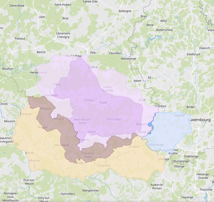
African swine fever: zoning
Zoning for the control of African swine fever in Wallonia, Grand Est and Luxembourg
- Sources: SPW DEMNA (Wallonie), ANF (Luxembourg), DRAAF (Grand Est)
Simple
- Date (Creation)
- 2019-03-28T00:00:00
- Date (Revision)
- 2022-02-24T00:00:00
- Citation identifier
- / 14f72fb3-fb08-408b-992b-a0bbad9286f1
- Presentation form
- Digital map
- Status
- Completed
- Maintenance and update frequency
- Continual
- Keywords
-
-
Swine fever, zoning
-
-
Entités dans la Grande Région
-
-
Greater Region
-
-
gis-gr.eu themes
-
-
Agriculture
-
-
gis-gr.eu structure
-
-
Agriculture>African swine fever
-
- Keywords
-
-
gis-gr.eu
-
- Access constraints
- Other restrictions
- Spatial representation type
- Vector
- Denominator
- 100000
- Language
- Deutsch
- Language
- Français
- Language
- English
- Character set
- UTF8
- Topic category
-
- Boundaries
- Biota
- Farming
N
S
E
W
))
- Reference system identifier
- EPSG / http://www.opengis.net/def/crs/EPSG/0/3857
- Distribution format
-
Name Version PDF
JPEG
SHAPE
- OnLine resource
-
Protocol Linkage Name OGC:WMS-1.3.0-http-get-map
https://ws.geoportail.lu/wss/service/GR_Agriculture_WMS/guest African_swine_fever_zoning_Luxembourg
WWW:LINK-1.0-http--samples
https://map.gis-gr.eu/theme/agriculture?version=3&zoom=8&X=667917&Y=6394482&lang=en&layers=1814&opacities=1&bgLayer=basemap_2015_global Interactive map
OGC:WMS-1.3.0-http-get-map
https://ws.geoportail.lu/wss/service/GR_Agriculture_WMS/guest African_swine_fever_zoning_France
OGC:WMS-1.3.0-http-get-map
https://ws.geoportail.lu/wss/service/GR_Agriculture_WMS/guest African_swine_fever_zoning_Wallonia
OGC:WFS
https://ws.geoportail.lu/wss/service/GR_Agriculture_WFS/guest Agriculture:African_swine_fever_fence_Wallonia
OGC:WFS
https://ws.geoportail.lu/wss/service/GR_Agriculture_WFS/guest Agriculture:African_swine_fever_fence_France
OGC:WFS
https://ws.geoportail.lu/wss/service/GR_Agriculture_WFS/guest Agriculture:African_swine_fever_fence_Luxembourg
Metadata
- File identifier
- 14f72fb3-fb08-408b-992b-a0bbad9286f1 XML
- Metadata language
- Français
- Character set
- UTF8
- Hierarchy level
- Dataset
- Hierarchy level name
-
dataset
- Date stamp
- 2025-01-10T08:56:56
- Metadata standard name
-
ISO 19115:2003/19139
- Metadata standard version
-
1.0
- Other language
-
Language Character encoding English UTF8 German UTF8 French UTF8
)))