 geocatalogue.geoportail.lu
Orthophoto 2010 de l'administration du cadastre et de la topographie
Orthophoto 2010 vun der Kadasterverwaltung
Orthophoto 2010 of the administration du cadastre et de la topographie
Orthophoto 2010 der administration du cadastre et de la topographie
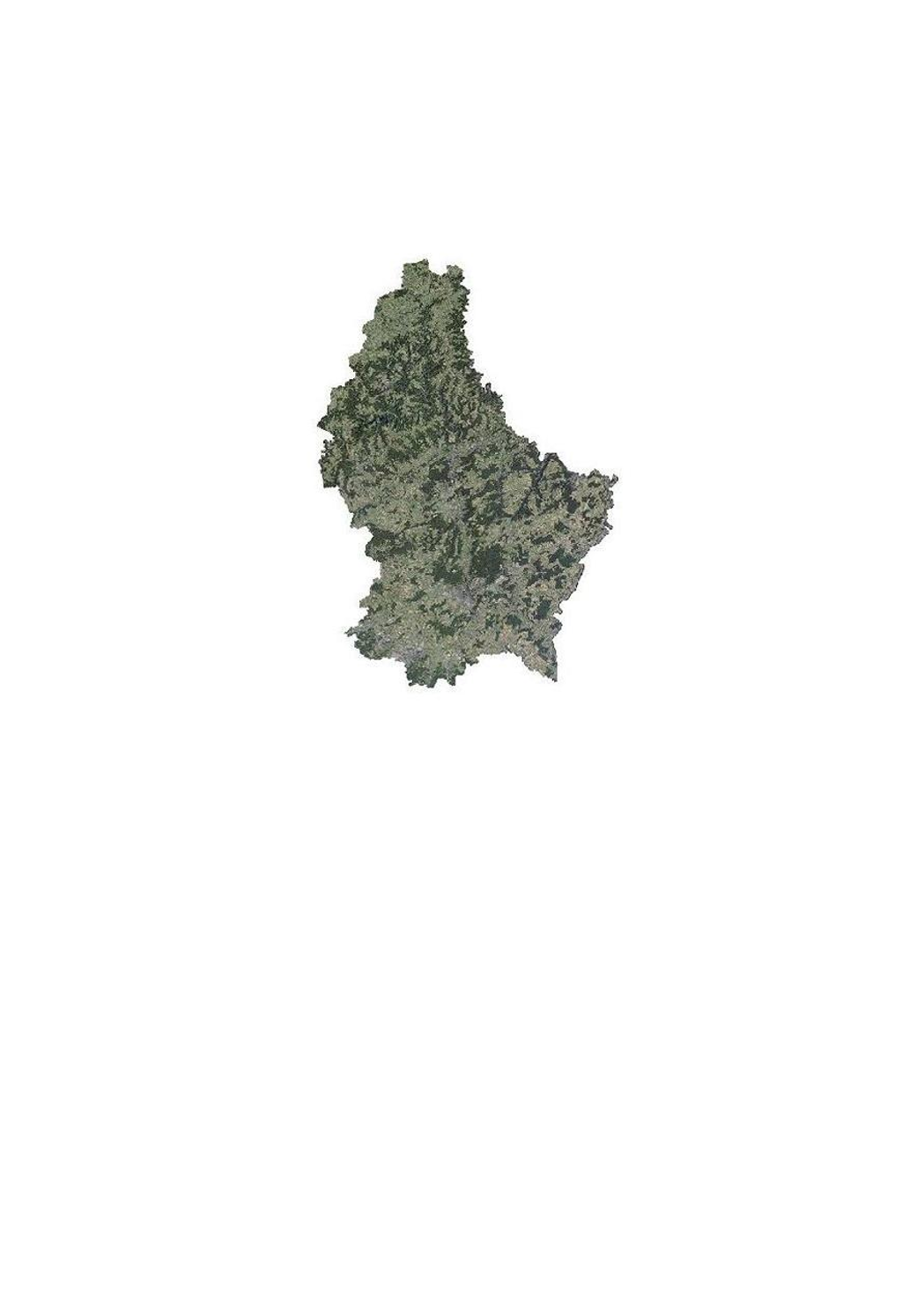
Cette couche contient les orthophotos officielles couvrant le territoire national, et qui ont été faites suivant un survol en été 2010 sous la responsabilité de l'administration du cadastre et de la topographie.
Dëse Layer enthält déi offiziell Orthophoto vum nationale Gebitt vu Lëtzebuerg, déi opgronn vun enger Iwwerfléiung am Summer 2010 am Optrag vun der administration du cadastre et de la topographie gemaach gouf.
This layer contains the official orthophotos covering the national territory of Luxemburg, and that have been produced following a surveying flight in summer 2010 under the responsibility of the administration du cadastre et de la topographie.
Dieser Layer enthält die amtlichen Orthophotos vom nationalen Gebiet des Großherzogtums Luxemburg, die ausgehend von einer Überfliegung im Sommer 2010 unter der Verantwortung der administration du cadastre et de la topographie erstellt wurden.
Simple
-
Date (Création)Date (Création)Date (Creation)Datumsangaben (Erstellung)
- 2010-06-01T00:00:00
-
Date (Révision)Date (Révision)Date (Revision)Datumsangaben (Überarbeitung)
- 2010-06-01T00:00:00
-
IdentificateurIdentificateurCitation identifierIdentifikator
- / 0faf4bdb-a54b-42d7-942c-4e52fa66e963
-
Forme de la présentationForme de la présentationPresentation formPräsentationsform
-
Carte numériqueCarte numériqueDigital mapDigitale Karte
-
EtatEtatStatusBearbeitungsstatus
-
Mise à jour continueMise à jour continueOn goingKontinuierliche Aktualisierung
- Point of contact
-
Organisation name Individual name Electronic mail address Role Administration du Cadastre et de la Topographie
Service du géoportail et de l'ILDG (ACT)
Point de contactPoint de contactPoint of contactAnsprechpartner
-
Fréquence de mise à jourFréquence de mise à jourMaintenance and update frequencyÜberarbeitungsintervall
-
Lorsque nécessaireLorsque nécessaireAs neededBei Bedarf
-
Entités au Grand-Duché de Luxembourg
-
-
Grand-Duché du Luxembourg
Grand-Duché du Luxembourg
Grand-Duché du Luxembourg
Grand-Duché du Luxembourg
-
- Keywords
-
- Keywords
-
-
orthophotos
Orthophoto
Orthophoto
Orthophoto
-
image
Loftbild
Image
Bild
-
aérienne
Geodaten
aerial
Luftbild
-
géodonnée
Orthofoto
geodata
Geodaten
-
geoportail.lu
geoportail.lu
geoportail.lu
geoportail.lu
-
-
geoportail.lu themes
-
-
Grand Public
Allgemeng
Main
Allgemein
-
Eau
Wasser
Water
Wasser
-
-
geoportail.lu structure
-
-
Grand Public>Couverture du sol>Images aériennes et satellites
Grand Public>Couverture du sol>Images aériennes et satellites>Loft- a Satellitebiller
Main>Land surface>Orthophoto-images
Allgemein>Oberflächendarstellung>Luft und Satellitenbilder
-
Eau>Données de base>Photographies aériennes et spatiales
Eau>Données de base>Photographies aériennes et spatiales>Loft- an Satellitebiller
Water>Geographical location>Aerial and satellite photographs
Wasser>Basisdaten>Luft- und Satellitenbilder
-
-
Contraintes d'utilisationContraintes d'utilisationUse constraintsNutzungseinschränkungen
-
Autres restrictionsAutres restrictionsOther restrictionsBenutzerdefinierte Einschränkungen
- Other constraints
-
Creative Commons 1.0 Universal (CC0 1.0) Public Domain Dedication
-
Type de représentation spatialeType de représentation spatialeSpatial representation typeRäumliche Darstellungsart
-
VecteurVecteurVectorVektor
-
Dénominateur de l'échelleDénominateur de l'échelleDenominatorMaßstabszahl
- 5000
-
Encodage des caractèresEncodage des caractèresCharacter setZeichensatz
-
Utf8Utf8UTF8Utf8
-
Catégorie ISOCatégorie ISOTopic categoryISO-Thematik
-
-
Carte de référence de la couverture terrestreCarte de référence de la couverture terrestreImagery base maps earth coverOberflächenbeschreibung
-
Sciences de la terre, géosciencesSciences de la terre, géosciencesGeoscientific informationGeowissenschaften
-
))
-
Nom du système de référenceNom du système de référenceReference system identifierIdentifikator des Referenzsystems
- EPSG / http://www.opengis.net/def/crs/EPSG/0/2169
- OnLine resource
-
Protocol Linkage Name OGC:WMS-1.3.0-http-get-map
https://wms.geoportail.lu/public_map_layers/service 342
342
342
342
OGC:WMS-1.3.0-http-get-map
http://wmts1.geoportail.lu/opendata/service?request=getCapabilities&service=WMS&version=1.3.0 ortho_2010
WWW:LINK-1.0-http--link
https://data.public.lu/fr/datasets/orthophoto-officelle-du-grand-duche-de-luxembourg-edition-2010/
- OnLine resource
-
Protocol Linkage Name https://map.geoportail.lu/theme/main?version=3&zoom=8&X=667917&Y=6394482&lang=fr&layers=343&opacities=1 Orthophoto 2013
Orthophoto 2013
Orthophoto 2013
Orthophoto 2013
- OnLine resource
-
Protocol Linkage Name https://map.geoportail.lu/theme/main?version=3&zoom=8&X=667917&Y=6394482&lang=fr&layers=342&opacities=1 Orthophoto 2010
Orthophoto 2010
Orthophoto 2010
Orthophoto 2010
Metadata
-
Identifiant de la ficheIdentifiant de la ficheFile identifierMetadatensatzidentifikator
- 0faf4bdb-a54b-42d7-942c-4e52fa66e963 XML
-
LangueLangueMetadata languageSprache
- Français
-
Jeu de caractèresJeu de caractèresCharacter setZeichensatz
-
Utf8Utf8UTF8Utf8
-
Type de ressourceType de ressourceHierarchy levelHierarchieebene
-
Jeu de donnéesJeu de donnéesDatasetDatenbestand
- Hierarchy level name
-
dataset
-
Date des métadonnéesDate des métadonnéesDate stampDatum
- 2021-02-04T23:52:37
- Metadata standard name
-
ISO 19115:2003/19139
- Metadata standard version
-
1.0
- Metadata author
-
Organisation name Individual name Electronic mail address Role Administration du Cadastre et de la Topographie
Service du géoportail et de l'ILDG (ACT)
Point de contactPoint de contactPoint of contactAnsprechpartner
- Other language
-
Language Character encoding FrançaisFranséischFrenchFranzösischUtf8Utf8UTF8Utf8LuxembourgeoisLëtzebuergeschLuxembourgish; LetzeburgeschLuxemburgischUtf8Utf8UTF8Utf8AnglaisEngleschEnglishEnglischUtf8Utf8UTF8Utf8AllemandDäitschGermanDeutschUtf8Utf8UTF8Utf8
)))