 geocatalogue.geoportail.lu
Cartographie du milieu physique 2021 [évaluation en 5 classes]
Strukturgütekartéirung 2021 [5-stufeg Bewertung]
Structural quality mapping 2021 [5-stage evaluation]
Strukturgütekartierung 2021 [5-stufige Bewertung]
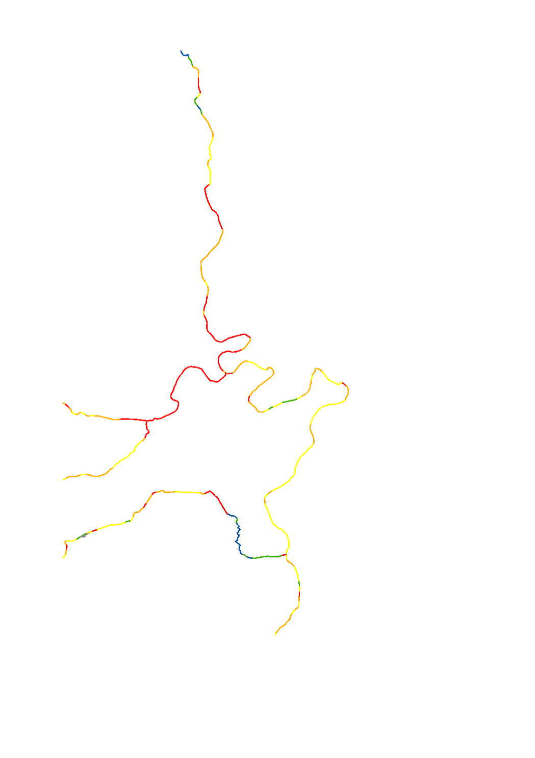
L'état hydromorphologique est évalué tous les 6 ans par un monitoring suivant une méthodologie conforme aux exigences de la directive cadre sur l'eau (Dir 2000/60/CE). La réalisation d’une cartographie du milieu physique représente une partie de ce monitoring. Dans le cadre de la réalisation de cette cartographie, en tout 31 paramètres sont relevés au niveau du lit mineur, des berges et de la plaine alluviale. La cartographie du milieu physique des masses d'eau de surface fournit ainsi des informations détaillées sur la morphologie des cours d'eau ainsi que sur leur continuité. Les tronçons cartographiés ont été évalués dans ce cas selon une échelle à cinq niveaux. Les résultats de l’évaluation ont été agrégés à une évaluation globale par tronçon cartographié.
Den hydromorphologechen Zoustand gouf mat engem zur Wasserrahmenrichtlinn konformen Monitoring ermëttelt. D’Erstelle vun enger Strukturgütekartéierung ass een Deel vun esou engem Monitoring. Am Kader vun den Aarbechten zu der Strukturgütekartéierung sinn am Ganzen 31 Parameter am Bereich Suel, Ufer an Land opgeholl ginn. D’Strukturgütekartéierung enthält demno détailléiert Informatiounen zur Morphologie vun de Gewässer an hirer Durchgängegkeet. D‘Bewertung vun de kartéierten Abschnitter gouf an dësem Fall op Basis vu fënnef Klasse gemeet. D’Resultater vun der Bewertung sinn dunn zu enger Gesamtbewertung pro kartéiertem Abschnitt aggrégéiert ginn.
The hydromorphological status was determined by a monitoring compliant with the Water Framework Directive (Directive 2000/60/EU). The elaboration of a structural quality mapping is one part of this monitoring. Within the scope of the work on the structural quality mapping, a total of 31 parameters in the area of the river bed, the river bank and the floodplain are assessed so that the structural quality mapping contains detailed information on the river morphology and the river continuity. In this case, the evaluation of the mapped sections is based on five classes. The results of the evaluation were aggregated into an overall evaluation per mapped section.
Der hydromorphologische Zustand wird alle 6 Jahre anhand eines Monitorings konform zur Wasserrahmenrichtlinie (RL 2000/60/EU) ermittelt. Die Erstellung einer Strukturgütekartierung ist ein Teil dieses Monitorings. Im Rahmen der Arbeiten zur Strukturgütekartierung werden insgesamt 31 Einzelparametern im Bereich Sohle, Ufer und Land erhoben sodass, die Strukturgütekartierung detaillierte Informationen zur Gewässermorphologie und der Durchgängigkeit enthält. Die Bewertung der Kartierabschnitte erfolgte in diesem Fall mittels fünf Strukturklassen. Die Resultate der Bewertung wurden zu einer Gesamtbewertung pro Kartierabschnitt aggregiert.
Simple
-
Date (Création)Date (Creation)Datumsangaben (Erstellung)Date (Création)
- 2021-09-22T00:00:00
-
IdentificateurCitation identifierIdentifikatorIdentificateur
- / 0e36b3e4-8811-43b6-9f2d-a2ea26c817cb
-
Forme de la présentationPresentation formPräsentationsformForme de la présentation
-
Carte numériqueDigital mapDigitale KarteCarte numérique
-
EtatStatusBearbeitungsstatusEtat
-
FinaliséCompletedAbgeschlossenFinalisé
-
Entités au Grand-Duché de Luxembourg
-
-
Grand-Duché du Luxembourg
Grand-Duché du Luxembourg
Grand-Duché du Luxembourg
Grand-Duché du Luxembourg
-
- Keywords
-
-
Masse d'eau de surface, directive 2000/60/CE, hydromorphologie, cartographie du milieu physique 2015, 5 classes
Iwwerflächenwaasser, Richtlinn 2000/60/CE, Hydromorphologie, Strukturgütekartéierung, 5 Klassen
Surface water body, Directive 2000/60/CE, hydromorhology, structural quality mapping, 5 classes
Oberflächenwasser-körper, Richtlinie 2000/60/EU, Hydromorphologie, Strukturgütekartierung, 5 Klassen
-
- Keywords
-
-
geoportail.lu
geoportail.lu
geoportail.lu
geoportail.lu
-
-
geoportail.lu themes
-
-
Eau
Wasser
Water
Wasser
-
-
geoportail.lu structure
-
-
Eau>Directive-cadre sur l'eau [DCE]>Plan de gestion 2021
Wasser>Wasserrahmenrichtlinie [WRRL]>Bewirtschaftungsplang 2021
Water>Water framework directive [WFD]>River Basin Management Plan 2021
Wasser>Wasserrahmenrichtlinie [WRRL]>Bewirtschaftungsplan 2021
-
-
Contraintes d'accèsAccess constraintsZugriffseinschränkungenContraintes d'accès
-
Autres restrictionsOther restrictionsBenutzerdefinierte EinschränkungenAutres restrictions
-
Type de représentation spatialeSpatial representation typeRäumliche DarstellungsartType de représentation spatiale
-
VecteurVectorVektorVecteur
-
Dénominateur de l'échelleDenominatorMaßstabszahlDénominateur de l'échelle
- 0
-
Langue de la ressourceLanguageSpracheLangue de la ressource
- Français
-
Encodage des caractèresCharacter setZeichensatzEncodage des caractères
-
Utf8UTF8Utf8Utf8
))
-
Fréquence de mise à jourMaintenance and update frequencyÜberarbeitungsintervallFréquence de mise à jour
-
onceonceonceonce
-
Nom du système de référenceReference system identifierIdentifikator des ReferenzsystemsNom du système de référence
-
EPSG
/
http://www.opengis.net/def/crs/EPSG/0/2169
- OnLine resource
-
Protocol Linkage Name WWW:LINK-1.0-http--link
https://data.public.lu/fr/datasets/cartographie-du-milieu-physique-2021-evaluation-en-5-classes/ OGC API-Features
https://features.geoportail.lu/collections/2226 OGC API - Features
- OnLine resource
-
Protocol Linkage Name https://map.geoportail.lu/theme/main?version=3&zoom=8&X=667917&Y=6394482&lang=fr&layers=2226&opacities=1 Cartographie du milieu physique 2021 [évaluation en 5 classes]
Strukturgütekartéirung 2021 [5-stufeg Bewertung]
Structural quality mapping 2021 [5-stage evaluation]
Strukturgütekartierung 2021 [5-stufige Bewertung]
OGC:WMS-1.3.0-http-get-map
https://wms.geoportail.lu/public_map_layers/service 2226
Metadata
-
Identifiant de la ficheFile identifierMetadatensatzidentifikatorIdentifiant de la fiche
- 0e36b3e4-8811-43b6-9f2d-a2ea26c817cb XML
-
LangueMetadata languageSpracheLangue
- Français
-
Jeu de caractèresCharacter setZeichensatzJeu de caractères
-
Utf8UTF8Utf8Utf8
-
Type de ressourceHierarchy levelHierarchieebeneType de ressource
-
Jeu de donnéesDatasetDatenbestandJeu de données
- Hierarchy level name
-
dataset
-
Date des métadonnéesDate stampDatumDate des métadonnées
- 2022-12-20T09:29:59Z
- Metadata standard name
-
ISO 19115:2003/19139
- Metadata standard version
-
1.0
- Metadata author
-
Organisation name Individual name Electronic mail address Role Administration de la gestion de l'eau
Division de l'hydrologie
Point de contactPoint of contactAnsprechpartnerPoint de contact
- Other language
-
Language Character encoding LëtzebuergeschLuxembourgish; LetzeburgeschLuxemburgischLuxembourgeoisUtf8UTF8Utf8Utf8EngleschEnglishEnglischAnglaisUtf8UTF8Utf8Utf8DäitschGermanDeutschAllemandUtf8UTF8Utf8Utf8FranséischFrenchFranzösischFrançaisUtf8UTF8Utf8Utf8
)))