 geocatalogue.geoportail.lu
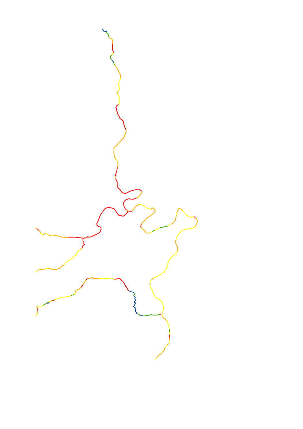
Structural quality mapping 2021 [5-stage evaluation]
The hydromorphological status was determined by a monitoring compliant with the Water Framework Directive (Directive 2000/60/EU). The elaboration of a structural quality mapping is one part of this monitoring. Within the scope of the work on the structural quality mapping, a total of 31 parameters in the area of the river bed, the river bank and the floodplain are assessed so that the structural quality mapping contains detailed information on the river morphology and the river continuity. In this case, the evaluation of the mapped sections is based on five classes. The results of the evaluation were aggregated into an overall evaluation per mapped section.
Simple
- Date (Creation)
- 2021-09-22T00:00:00
- Citation identifier
- / 0e36b3e4-8811-43b6-9f2d-a2ea26c817cb
- Presentation form
- Digital map
- Status
- Completed
-
Entités au Grand-Duché de Luxembourg
-
-
Grand-Duché du Luxembourg
-
- Keywords
-
-
Surface water body, Directive 2000/60/CE, hydromorhology, structural quality mapping, 5 classes
-
- Keywords
-
-
geoportail.lu
-
-
geoportail.lu themes
-
-
Water
-
-
geoportail.lu structure
-
-
Water>Water framework directive [WFD]>River Basin Management Plan 2021
-
- Access constraints
- Other restrictions
- Spatial representation type
- Vector
- Denominator
- 0
- Language
- Français
- Character set
- UTF8
))
- Maintenance and update frequency
- once
- Reference system identifier
- EPSG / http://www.opengis.net/def/crs/EPSG/0/2169
- OnLine resource
-
Protocol Linkage Name WWW:LINK-1.0-http--link
https://data.public.lu/fr/datasets/cartographie-du-milieu-physique-2021-evaluation-en-5-classes/ OGC API-Features
https://features.geoportail.lu/collections/2226 OGC API - Features
- OnLine resource
-
Protocol Linkage Name https://map.geoportail.lu/theme/main?version=3&zoom=8&X=667917&Y=6394482&lang=fr&layers=2226&opacities=1 Structural quality mapping 2021 [5-stage evaluation]
OGC:WMS-1.3.0-http-get-map
https://wms.geoportail.lu/public_map_layers/service 2226
Metadata
- File identifier
- 0e36b3e4-8811-43b6-9f2d-a2ea26c817cb XML
- Metadata language
- Français
- Character set
- UTF8
- Hierarchy level
- Dataset
- Hierarchy level name
-
dataset
- Date stamp
- 2022-12-20T09:29:59Z
- Metadata standard name
-
ISO 19115:2003/19139
- Metadata standard version
-
1.0
- Metadata author
-
Organisation name Individual name Electronic mail address Role Administration de la gestion de l'eau
Division de l'hydrologie
Point of contact
- Other language
-
Language Character encoding Luxembourgish; Letzeburgesch UTF8 English UTF8 German UTF8 French UTF8
)))